3. The 2007 flood season (continue)
3.2 Hydrological aspects - the Cambodian floodplain and Mekong Delt
Hydrological conditions over the Cambodian floodplain and within the Delta during the 2007 flood season (indicated in terms of water level rather than discharge) reflected those that prevailed upstream, as the results shown in Figure 32.
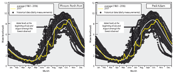

Figure 32. Cambodian Floodplain
and Mekong Delta - Historical mean and range of the annual
daily water level hydrograph at selected sites compared to
that for 2007.
- Water levels at Phnom Penh Port, Prek Kdam, Tan Chau and Chau Doc in early and late July and on into the first week of August were the lowest observed over the last to 28 to 48 years (Figure 32) and continued to be consistently well below average until a response to late monsoonal storms upstream occurred in late October.
- This late arrival of significant flood waters generated higher water levels from this time onwards, though throughout November and December during the flood recession these were only marginally above average.
- The onset of the flood season, here defined as the first sustained up-crossing of the long term mean annual water level, was up to three weeks late at Phnom Penh and Prek Dam and nearer two weeks in the Delta, though generally well outside of the characteristic window defined by the standard deviation (Table 13).
Table 13. Cambodian floodplain and
Mekong Delta onset and end dates of the 2007 flood season
compared to
their historical mean and standard deviation at selected locations.![]()
| Site | Onset of flood season | End of flood season | ||||
| Historical average | Standard deviation |
2007 | Historical average | Standard deviation |
2007 | |
| Phnom Penh Port | 10th July | 14 days | 4th August | 14th November | 14 days | 15th December |
| Prek Kdam | 11th July | 16 days | 5th August | 20th December | 17 days | 29th December |
| Tan Chau | 19th July | 20 days | 8th August | 18th December | 12 days | 14th December |
| Chau Doc | 23rd July | 17 days | 9th August | 19th December | 12 days | 27th December |
- The duration of the flood season was therefore curtailed (Table 14), with consequent implications for the period of time that natural riparian wetlands and the floodplain were inundated.
Table 14. Duration of annual flood
season on the Cambodian Floodplain and Mekong Delta. ![]()
| Site | Average historical duration of flood season. | Duration of 2007 flood season. |
| Phnom Penh Port | 158 days | 133 days |
| Prek Kdam | 163 days | 146 days |
| Tan Chau | 151 days | 128 days |
| Chau Doc | 148 days | 131 days |
- The depth and therefore the areal extent of this foreshortened period of inundation was also below normal due to below average seasonal water levels (Table 15).
Table 15. Cambodian Floodplain and
Mekong Delta – 2007 annual maximum water levels at selected
sites
compared to their historical means and standard deviations.![]()
| Site | Period of record | Annual maximum
water level (masl) |
||||
| Historical average | Standard deviation (m) | 2007 | ||||
| Phnom Penh Port | 1960 – 2007 | 9.02 | 0.67 | 8.85 | ||
| Prek Kdam | 1960 – 2007 | 9.08 | 0.73 | 8.86 | ||
| Tan Chau | 1980– 2007 | 4.30 | 0.54 | 4.14 | ||
| Chau Doc | 1980– 2007 | 3.82 | 0.58 | 3.62 | ||

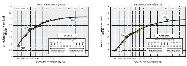
Figure 33. Cambodian Floodplain
and Mekong Delta - historical sample distribution of annual
maximum
water levels and General Extreme Value Type III approximating
distribution.![]()
- The end of the flood season in this sub-region of the Lower Mekong Basin occurs several weeks later than in reaches further upstream, where the characteristic date is the second and third week of November (refer back to Table 10). On the Cambodian Floodplain natural flood storage comes into effect while downstream of the Tonle Sap confluence with the Mekong mainstream the natural regulation storage in the Tonle Sap and Great Lake system becomes evident. The flow reversal as the Great Lake drains into the mainstream results in a further delay to the characteristic end of the flood season to the later weeks of December, while in some years the season can last well into January of the following year.
- The effect of over-bank storage on the floodplain is also evident from a plot of the distribution of historical annual maximum water levels, as indicted in Figure 33. The plotted points asymptotically approach some undefined upper limit as floodwater spills out of the channels onto the floodplain. The higher the levels become therefore the incremental difference decreases as the area of inundation increases. The plots also indicate that the maximum water levels achieved during the 2007 flood season were marginally below average and would occur on average about once in four to five years.1
3.3 The 2007 flood season - meteorological aspects.
With the exception of most of Cambodia and the Delta region, rainfall during the SW Monsoon of 2007 over the Mekong region was moderately below average. Figure 341 indicates the cumulative daily rainfall at selected sites during 2007:

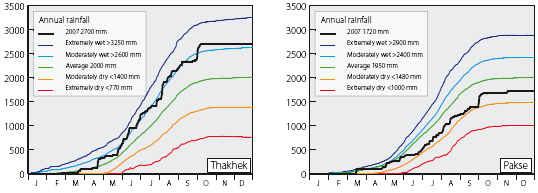
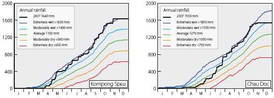
Figure 34. Cumulative daily rainfall
at selected sites in the LMB, indicating average, moderate
and
extreme wet and dry conditions and those during 2007.![]()
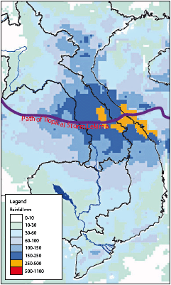
Figure 35. Track of severe topical
storm
Lekima and associated rainfall within first
week of October, 2007.
- Reflecting the general regional situation, that at Chiang Saen, Vientiane and Pakse was average or below, though that at Thakhek, where it was considerably greater than average, reveals that there were local exceptions.
- In Cambodia and Vietnam the seasonal rainfall does not reflect meteorological conditions within the wider Basin and was very much above average. Locally, at Kompong Speu in Cambodia for example, the seasonal rainfall total was extremely high, though this appears to be largely explained by two significant storm periods during late April and early May.
- The rainfall generally accumulated steadily indicating that there were few periods of exceptional storm activity outside of the Delta and Cambodia. This lack of large accumulations of storm rainfall over a few days would be a major factor in explaining the regionally low stream flows and below average Mekong flood during the year.
- The only major regional storm event that had any large scale hydrological impact occurred during the first week of October. It resulted in the 2007 peak discharge at Kratie and the only time in the year that water levels in Cambodia and the Delta rose above average (see Figures 30 and 32).
- This was severe tropical storm Lekima, which tracked across the central areas of the LMB and resulted in heavy rainfall within the many of the large left bank tributaries, particularly the Se Bang Hieng, Se Bang Fai, Se Done, Se Kong and Se San (Figure 35). Three day rainfalls in excess of 250 mm were widespread.
1 The water level quantiles quoted in Figure 33 for Phnom Penh Port have been revised downwards from those given in Appendix A1.3 of the 2006 Annual Flood Report. The other three remain the same.
Choose a newsletter: