2. The flood hydrology of the major tributaries in the Lower Mekong Basin
2.1 An introductory note upon the impacts of land-use change and deforestation on the flood rgime of the Mekong tributary rivers
The belief that deforestation causes an increase in the frequency and severity of major floods, and compounds the damage that they cause, appears to be widespread. This view is as widely held within the Lower Mekong Basin as it is throughout the tropical world. However, an authoritative report from the UNs Food and Agriculture Organization (FAO) and the Centre for International Forestry Research (Cifor) says that the evidence shows no link. Citing evidence from Bangladesh, Nepal, South Africa, Thailand and the United States it shows that the frequency and extent of major floods has not changed over the last century or two, despite drastic reductions in forest cover. Loss of forest cover does play a role in the generation of smaller floods and in the loss of fertile topsoil but, because forests do help to reduce floods in small areas, people assume that the effect must also apply to severe floods over large catchment areas.
According to the report, after a review of specific scientific studies worldwide, the clear indication is that changes in land-use and land-use cover have only a minor impact upon the risk and severity of large-scale flood events. The local effect from forests disappears as the catchment scale becomes larger and larger. That flood damage is increasing is unquestioned. However, this is not linked to the increasing magnitude of events, but is instead due to the growing global population and the consequent expansion of human settlements into areas that had once been marginal. As a result, each flood claims more lives than it would have done a century ago. In addition, the diversion of watercourses by human activity and the construction of flood protection works often moves the problem from upstream to downstream areas.
There are arguments and some evidence to suggest that the actual frequency of floods is beginning to increase, possibly in response to climate change, a major consequence of which, it is generally agreed, will be an increase in the incidence of extreme events. However, the evidence is as yet inconclusive. One scenario, based on the outputs of global climate modelling, is that periods of storm rainfall (and the causal climatic conditions) will be more variable with an increase in the occurrence of extremes. This, it is proposed, will be combined with longer dry spells between such events.
These observations and conclusions provide an important prelude to this overview of the flood hydrology of the major tributaries of the Mekong, where the damage and loss of life from flash floods has been very much in the news in recent years. However, this increase in damage is the result of increased regional prosperity and the consequent expansion of the infrastructureand its economic value that is at risk. A return to this theme is made in Section 2.5 where the potential impacts of climate change are also briefly examined.
2.2 The geography of the major tributary contributions to the flood hydrology of the Mekong
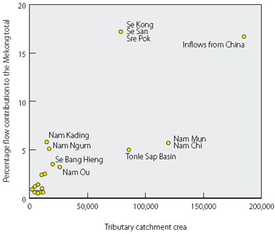
Figure 1. Percentage contribution
of the major Mekong tributary systems to
mainstream annual flow, as a function of catchment area.
The physical geographical region defined by the Lower Mekong Basin is a variable one in terms of its topography, land cover, and rainfall climate. These three factors obviously have a major impact on regional hydrological response and its spatial variability, which is reflected in the contributions that the major tributaries make to the mainstream flows. The principal feature of the hydrology of the basin in this respect is that, despite the fact that it is by far the largest Mekong tributary system in terms of area, the Mun-Chi Basin in Thailand accounts for less than 6% of mainstream flow, a figure that is matched by the Nam Kading and Nam Ngum, the catchment areas of which amount to only 12% of that of the Mun-Chi (Figure 1).
This distribution of annual rainfall is the main factor that controls the geographic variability of river runoff, though topography also plays an important role. The mean annual rainfall over the Mun Chi Basin varies between 1000 and 1500 mm, compared to 2500 to more than 3000 mm over a number of the large left bank tributaries in Lao PDR (Figure 2). The landscape of the Mun Chi is also very flat, such that only between 25 and 50% of the rainfall is translated into stream flow, which compares to up to 75% over the much wetter and steeper left bank tributary basins. The geographical distribution of tributary runoff is shown in Figure 3.
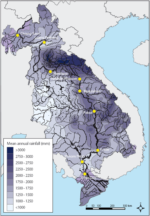
Figure 2. Lower
Mekong Basin mean annual rainfall (mm).
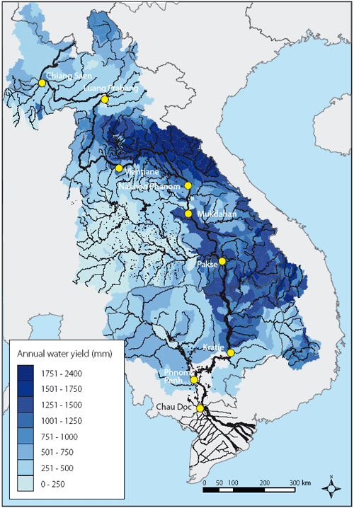
Figure 3. Lower
Mekong Basin - mean annual runoff by tributary sub-basin (mm).
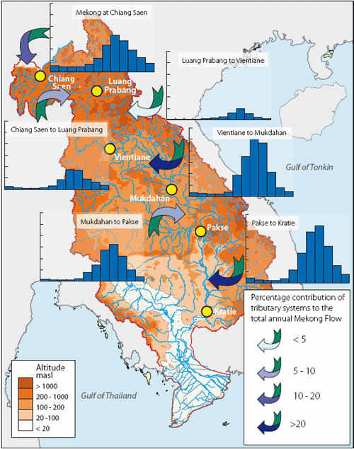
Figure 4. Mean
monthly and annual tributary system contributions to Mekong
mainstream
discharge. Note: Vertical scales on the bar charts is 0 to
12,000 cumecs.
The mean annual and monthly tributary flow contributions to the mainstream are summarised in Figure 4, these being set out geographically between key locations along the mainstream itself. For the sake of consistency we consider the Upper Mekong in China as the tributary at Chiang Saen:
- Here the average annual flow is about 18% of the total flow at Kratie, at which point 90% of overall Mekong flow is already in the system. Downstream of Kratie the Tonle Sap Basin contributes most of the remaining 10%.
- Between Chiang Saen and Vientiane tributary inflows are modest, particularly those downstream of Luang Prabang. The Nam Ou, Nam Tha and Nam Khan rivers contribute most of the mainstream flows in this reach
- It is downstream of Vientiane that the major hydrological contributions occur. The tributary systems between Vientiane and Mukdahan and between Pakse and Kratie are the major sources of floodwater. Those between Mukdahan and Pakse provide rather less, a fact explained by the low relative levels of runoff in the Mun Chi Basin, which although it is the largest Mekong tributary system in terms of area, it drains a flat landscape over which annual rainfall is significantly lower than that for the wider region (Figure 2).
The mean annual tributary contributions to the mainstream are summarised in Table 1, reach by reach. In order to simplify matters for the detailed assessment of the tributary flood hydrology, the number of mainstream reaches was reduced to three between Chaing Saen and Kratie: Chiang Saen to Vientiane, Vientiane to Pakse and Pakse to Kratie. These three tributary groups broadly reflect the regional distinctions in tributary flood hydrology. Table 1. Mean annual tributary system contributions to total Mekong flow.
| Table 1. Mean annual tributary system contributions to total Mekong flow. | ||||
| Tributary System. | Mean Annual Flow (km3) |
As % of total Mekong | ||
| Yunnan component at Chiang Saen | 84.5 |
18 |
||
| Chiang Saen to Luang Prabang | 38.5 |
8 |
||
| Luang Prabang to Vientiane | 17.6 |
4 |
||
| Vientiane to Mukdahan | 104.8 |
23 |
||
| Mukdahan to Pakse | 65.9 |
14 |
||
| Pakse to Kratie | 106.2 |
24 |
||
| Kratie to Delta | 39.8 |
9 |
||
| Totals | 457.3 |
100 |
||
2.3 Chiang Saen to Vientiane - the regional history of tributary floods and flooding
The recent history of fl ood events in northern Thailand is summarised in the fi gure below, which illustrates their annual frequency and the exposure of the region to the fl ood hazard.
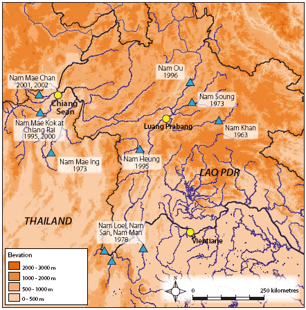
Figure 5. Northern Thailand and northern
Lao PDR fl ash fl ood events of
recent years.
Of these regional fl ood events in recent years, that of 2002 in Chiang Rai and Loei provinces in Thailand was amongst the most severe with 40 people reported killed . Five thousand people had to be evacuated and three thousand properties were damaged. The fl ood of 2001 was responsible for over 100 deaths.
Going back even further in history each of the years from 1918 and 1920 featured devastating events, as did 1953. Even further back in time the original capital of the Lanna Kingdom had to be moved to Chiang Mai at the end of the 13th Century because of frequent fl ood inundation. These events obviously occurred long before the regional forests were reduced by logging, which has been blamed for a supposed increase in the frequency of the fl ood hazard (see below) since the 1960s. The logging of natural forests was banned in Thailand following the national fl ood emergency of 1988.
In the Northern Lao PDR provinces of Huaphan, Pongsaly, Luangnamtha and Luang Prabang significant flooding has been similarly frequent, having occurred in 1991, 1995, 1996, 2000, 2002, 2005 and 2006. Prior to that the largest regional flood to have occurred historically was that of September 1966, associated with the incursion of Cyclone Phyllis over the large northern tributaries.
2.4 Chiang Saen to Vientiane - the regional tributary systems.
A schematic of the regional tributary rivers is presented in Figure 6 and Tables 2 and 3 summarise their areas and the hydrological data that are available. In the latter case the information only refers to those sites where the records are longer than a few years and considered to be reasonably reliable.
Table 2. Major tributaries to the Mekong mainstream Chiang Saen to Vientiane.
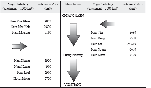
- The reach comprises a complex of right bank tributaries in north and northeast Thailand, principally the Nam Mae Khan, Nam Mae Ing, Nam Mae Kok and Nam Loei and a number of generally larger left bank tributaries in northern Lao PDR. Of these the Nam Ou is by far the most significant in terms of drainage area and discharge.
- The total tributary area is 110,000 km2 of which stream flow data are available for almost 60,000 km2.
- Annual tributary runoff is less than in other parts of the Lower Mekong Basin to the south, particularly from the large left bank tributary systems downstream of Vientiane (Figure 3).
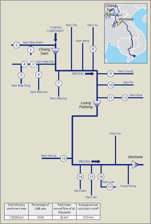
Figure 6. Schematic of the major Mekong
tributary systems between the Chinese border and
Vientiane, indicating the sites at which discharge data are
available. (Numbers refer to the
right hand column in Table 3.)
- The sub-reach between Luang Prabang and Vientiane is unique in the LMB in that there are no large left bank tributaries, a fact which largely explains the small contribution it makes to the overall Mekong flow (Figure 4).
- Flash floods in this area of the Mekong basin have been a key feature of its hydrological history. It has also been an area where deforestation and slash and burn agriculture have been widespread, leading to arguments that the consequent landscape changes have been a major contributory factor to flooding.
| Table 3. Tributary sites between Chiang Saen and Vientiane at which functional hydrometric data | |||||||
| are available. (Sequence numbers refer to those in Figure 3.) | |||||||
| Sketch | Station No. | River | Site | Catchment (km2) | Mean annual flow (cumecs) | ||
| 1 | 040201 | Nae Mae Chan | Ban Huai Yano Mai | 200 | 5 | ||
| 2 | 040101 | Nam Mae Kham | Ban Pa Yong | 520 | 11 | ||
| 3 | 050104 | Nam Mae Kok | Chiang Rai | 6060 | 122 | ||
| 4 | 050105 | Nam Mae Kok | Ban Tha Ton | 2980 | 69 | ||
| 5 | 050201 | Nam Mae Fang | Ban Tha Mai Liam | 1800 | 27 | ||
| 6 | 050301 | Nam Mae Lao | Ban Thai Sai | 3080 | 28 | ||
| 7 | 070103 | Nam Mae Ing | Theong | 5700 | 64 | ||
| 8 | 100102 | Nam Ou | Muong Ngoy | 19,700 | 417 | ||
| 9 | 110101 | Nam Soung | Ban Sibounhom | 5800 | 90 | ||
| 10 | 110201 | Nam Pa | Ban Kok Van | 700 | 9 | ||
| 11 | 120101 | Nam Khan | Ban Mixay | 6100 | 96 | ||
| 12 | 120102 | Nam Khan | Ban Pak Bak | 5800 | 92 | ||
| 13 | 140101 | Nam Heung | Ban Pak Huai | 4090 | 40 | ||
| 14 | 140201 | Nam Man | Dan Sai | 400 | 6 | ||
| 15 | 140301 | Nam San | Dam Site | 700 | 9 | ||
| 16 | 150101 | Nam Loei | Wang Saphung | 1240 | 17 | ||
| 17 | 150102 | Nam Loei | Ban Wang Sai | 235 | 78 | ||
Choose a newsletter: