2. The flood hydrology of the major tributaries in the Lower Mekong Basin (Continue)
2.5 Chiang Saen to Vientiane - are flash floods becoming more common?

Figure 7. Regional annual number
of significant and extreme flood events
- 1970 to 2003. (See text for definitions).
The view that deforestation has increased the frequency and severity of flash floods is widely held, particularly in northern Thailand. Defining a significant event as a flood that was more than one standard deviation above the mean annual maximum flood peak, Figure 7 shows the regional incidence of such events between 1970 and 2003. Even if the figures are corrected for the number of station years available in each decade, the increased proportion and incidence of such events remains apparent from 1990 onwards. Of the 25 significant events observed since 1970, 16 or 65% occurred after 1990. Interestingly, none at all occurred during the 1980s. The regional median annual maximum event remained unchanged over the period as a whole.
There appears to be sufficient evidence on the basis of this simple analysis to suggest that significant floods have become more frequent over the last 15 years or so. Whether this is a response to external influences such as climate change is arguable. It may simply be part of the natural periodicity of such processes the fact that there were no significant events at all during the 1980s might be evidence in this regard. However, the timescale for which data are available is far too short to establish any such possible periodic patterns one way or the other. Nevertheless, it seems reasonable to conclude that after the logging ban in Thailand during the late 1980s, deforestation would appear not to be a factor to the increased frequency of events post 1990.
2.6 Chiang Saen to Vientiane - the hydrological assessment of extreme regional tributary flood events

Figure 8. Nam Mae Chan at Ban Huai
Yano Mai. Definition of significant and extreme floods
in the context of the events of 2001 and 2002.
Figure 8 shows a plot of the annual maximum flood events of 2001 and 2002 on the Nam Mae Chan at Ban Huai Yano Mai in northern Thailand. These are by far the largest on record for the river over the 24 years for which data are available (1980 2003), with peak discharges three standard deviations above the mean annual flood over the same period. Such events are quite distinct from the rest of the sample, which might be classified into significant events (greater than one standard deviation above the mean) and extreme events (greater than two standard deviations above the mean). Clearly the suspicion is that there are two weather processes at work, one that generates average and significant floods and one that generates those that are far more extreme.
This distinction may be linked to:
- typical monsoonal storms and average antecedent catchment conditions that result in the more typical or basic events, and;
- more extreme weather systems, such as intense tropical depressions, severe tropical storms and typhoons, which combine with wet or saturated antecedent catchment conditions to generate extreme or outlier events.
The picture that emerges from the following assessment of the most extreme historical regional flood events is that, except for the larger catchments in Lao PDR such as the Nam Ou, they are of short duration, typically three to four days. In addition:
- times to peak are extremely rapid, typically less than one day;
- antecedent flow conditions are often not linked in any significant way to the peak magnitude, though such is the rapid rate of recession of the flood hydrograph this may not of itself be a meaningful indication of the actual state of the catchment in terms of wetness and its ability to generate maximum rates of runoff during a storm.
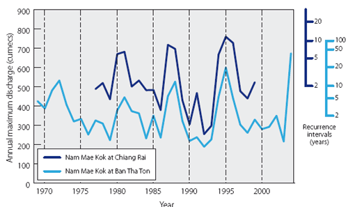
Figure 9. Nam
Mae Kok at Chiang Rai and at Ban Tha Ton. Annual maximum peak
discharges for the periods of available data and their annual
recurrence intervals.
Figure 9 shows the annual maximum discharges on the Nam Mae Kok at Chiang Rai and upstream at Ban Tha Ton over the years for which data are available. The indication is that flood peaks in excess of ten years occurred in 1972, 1988, 1995, and 2004, the latter being greater then the 1:30 year event at Ban Tha Thon (no data are available for Chiang Rai). Of the observed data at Chaing Rai, the largest event occurred in 1995 (though the 2004 event would have exceeded it significantly if the flows upstream at Ban Tha Ton are scaled accordingly). This 1995 event at Chiang Rai is shown in detail in Figure 10:
- It was not a flash flood in any real sense, the overall flood season hydrograph being quite coherent, with several independent peaks superimposed upon it rather than rising rapidly from a relatively low flow state. The associated daily rainfalls are also shown, with the maximum daily depth of 130 mm occurring on the 5th August. This depth has estimated annual recurrence interval of 1:5 years.
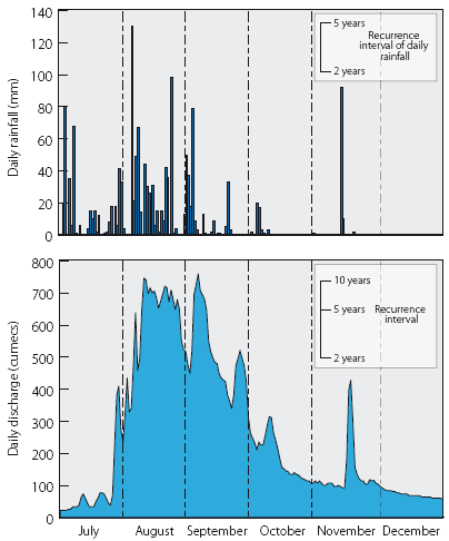
Figure 10. Nam
Mae Kok at Chiang Rai - 1995 flood hydrograph with associated
daily rainfall.
- It is the accumulated daily rainfalls that were responsible for the relative severity of the event, with the 5- and 10-day totals observed at Chaing Rai being exceptional, with recurrence intervals of 20 years.
The mean annual and monthly tributary flow contributions to the mainstream are summarised in Figure 4, these being set out geographically between key locations along the mainstream itself. For the sake of consistency we consider the Upper Mekong in China as the tributary at Chiang Saen:
| Table 4. Chiang Rai - cumulative rainfall, 5th to 14th August, 1995 and their recurrence interval. | |||
Storm duration
|
Dates August
1995 |
Cumulative
depth (mm) |
Recurrence
interval |
1 day |
5th |
130 |
5 years |
2 day |
5-6th |
150 |
10 years |
3 day |
5-7th |
200 |
10 years |
5 day |
5-9th |
280 |
20 years |
10 day |
5-14th |
400 |
20 years |
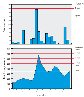
Figure 11.Nam Mae Kok at Ban
Tha Ton - the 2004 flood
hydrograph with associated daily rainfall at Mae Chan.
The later period of storm rainfall at the end of August and during the first few days of September produced a slightly higher flood peak. However, the cumulative depth over five days of 200 mm was unexceptional in terms of its recurrence interval, but it was far more effective in runoff terms since flows in the river were already high and the upstream catchment saturated.
The 2004 event in the Nam Mae Kok was much more severe with a flood peak of 650 cumecs at Ban Tha Thon. The corresponding peak discharge at Chiang Rai could have been anywhere between 800 and 1000 cumecs, possibly therefore as high as a 1:50 year event. It takes on much more of the appearance of a flash flood with discharges rising by over 400 cumecs in two days from a relatively modest initial flow condition (Figure 11). Finding daily rainfall conditions to link to the event proved a problem, indicative of the highly localised nature of intense storm rainfall bursts. The only local site with a storm rainfall pattern consistent with the flood runoff during September was that at Mae Chan, though even here the daily rainfalls were anything but extreme, even in terms of the accumulated total over five days. The later period of storm rainfall at the end of August and during the first few days of September produced a slightly higher flood peak. However, the cumulative depth over five days of 200 mm was unexceptional in terms of its recurrence interval, but it was far more effective in runoff terms since flows in the river were high and the catchment saturated.
The classic regional example of the extreme fl ash fl ood is provided by events on the Nam Loei, Nam San and Nam Man during August 1978 (Figure 12):
The classic regional example of the extreme fl ash fl ood is provided by events on the Nam Loei, Nam San and Nam Man during August 1978 (Figure 12):
- On all three rivers the flood is estimated to have had a peak discharge with a recurrence interval of at least 1:100 years.
- The hydrographs indicate extreme rates of flood rise from initial flow conditions that were very low. From the start of the event to the peak discharges increased by as much as 25 orders of magnitude over two days.
- Almost as quickly as flows rose to the peak they declined, such that the hydrograph overall had a small volume to peak ratio typical of the flash flood event.
- In itself this points to an extremely intense period of storm rainfall, but one with a relatively short duration.
- This is confirmed by the associated storm rainfalls at Loei and at Dan Sai which reveal that they were essentially confined to a single day, with none of any significance in the previous ten. The observed amounts, however, were not large enough to explain the event, unless the intensities were extreme and they occurred within a few hours. Clearly elsewhere in the local area depths of greater magnitude and exceptional intensity must have occurred.

Figure 13. The flash flood event on
the Nam Soung in Lao PDR during August 1973, with indicative
rainfall at Xiengkhoung.
A flood of similar character and recurrence interval and with the associated rainfall again apparently confined to a single day occurred on the Nam Soung in Lao PDR in August 1973 (Figure 13), though in this case the river was relatively high at the start of the event. Once again, the available observed daily rainfall data do not contain the local storm conditions that would have generated the event, only an indication of them.
Even quite large catchment areas within the region can develop classical flash flood conditions as Figure 14 illustrates for the Nam Khan at Ban Mixay in Lao PDR, where the upstream catchment area is over 6000 km2. Here the event of July 1963 had an estimated recurrence interval of over 100 years in terms of its peak discharge. The observed rainfall conditions at the time at Luang Prabang are hardly related at all to the magnitude of the flood event. The storm depths and intensities responsible would have occurred far up in the catchment towards the headwaters where no data are observed.
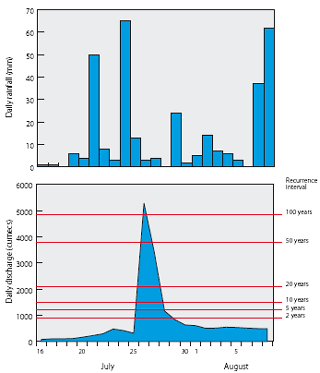
Figure 14: The flash flood event on
the Nam Khan at Ban Mixay in Lao PDR during July 1963. Rainfall
at Luang Prang was hardly related at all to the flood. This
would have occurred in the headwater reaches of the catchment
and was unrecorded.
No representative rainfall data at all are available for some of the largest extreme flash floods that have been observed, most particularly the outlier events on the Nam Mae Chan during 2001 and 2002 (see Figure 8), once again underscoring the conclusion that the storm events that cause them are highly localised, high intensity events of short duration. The details of the flood hydrographs for three such floods are shown in Figure 15, again illustrating the characteristic time distribution of flash flood runoff.
Not all of the largest events observed regionally are of the flash flood type. Longer duration storms can produce flood runoff distributed in a different and far less peaked pattern while catchment landscape in terms of less steep slopes can be a significant influence on hydrograph shape. An example, is that for the most extreme event recorded on the Nam Mae Ing at Theong during September 1973, which although the time to peak is very short the recession time is not. If the distribution of the storm rainfall that is associated with the event shown in Figure 16 is a reasonable approximation to the actual temporal pattern (if not to the amounts) then none occurred after the peak discharge was reached. Physical factors and natural catchment storage would then largely explain the longer flood recession time.
Catchment scale is another factor influencing the shape of the characteristic flood response hydrograph. The Nam Ou at Muong Ngoy in Lao PDR has a drainage area of almost 20,000 km2. In this case the time of concentration of the floodwater would typically be longer than within a smaller basin area such that flood rise would be less rapid. Recessions would also tend to be slower due to scale effects. The largest recorded event on the Nam Ou occurred in 1996 and is shown in Figure 17. It was a significant outlier, being almost twice the magnitude of the second rank ordered event in terms of peak discharge1. The hydrograph shows a time to peak of six days and a recession time of more than a week, which is probably a typical pattern for the larger tributaries within the Lower Mekong Basin. The number of 100 year events estimated within the region might appear be an issue. However, three of these occurred on the same date, associated with the same storm event. So collectively, they should be counted as one. The rest are independent events in time. This gives five 100 year floods within a total regional sample size of 534 station years of data, which is the statistical expectation.

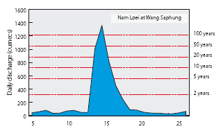


Figure 12. The classic flash flood.
Events on the Nam Loei, Nam San and Nam Man during August
1978, with the associated daily rainfall at Loei and at
Dan Sai.
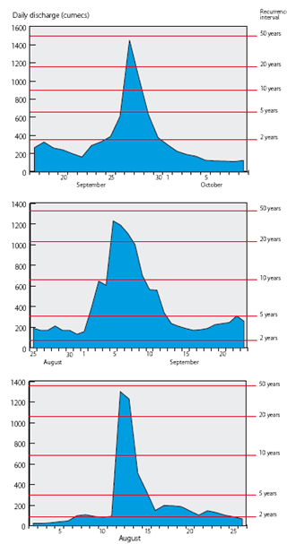
Figure 15: The largest observed flash
flood events on the Nam Heung (1995) and Nam Mae Chan (2001
and 2002). No explanatory or indicative rainfall data are
available from the records for these events.
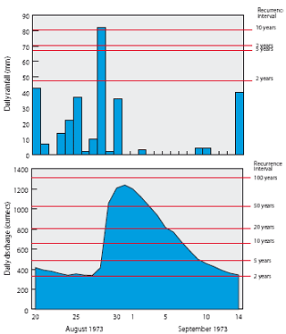
Figure 16. The largest observed flood
event on the Nam Mae Ing. If the indicative temporal pattern
of the 'local' storm rainfall is accurate then none occurred
after the peak and the longer flood recession time would
be explained by catchment factors such as natural flood
storage.
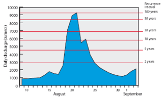
Figure 17. The hydrograph of the largest
flood event observed on the Nam Ou since 1985, while illustrates
the effects of catchment scale upon hydrograph shape.
_____________
Choose a newsletter: