2. The flood hydrology of the major tributaries in the Lower Mekong Basin (Continue)
2.7 Vientiane to Pakse - the regional tributary systems
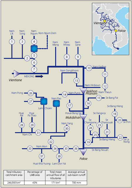
Figure 18. Vientiane to Pakse - schematic
of the major Mekong tributary systems
indicating the sites at which discharge data are available.
(Numbers refer to those
in Table 6.)
In this reach the large left bank tributaries in Lao PDR begin to exert their dominant influence on the flood hydrology of the Mekong, starting with the entry of the Nam Ngum 50 km downstream of Vientiane. The combined mean annual flow of all tributaries between Vientiane and Pakse is 171 km3, almost 40% of the Mekong total. The major contributions to this figure are made from the left bank by the Nam Ngum, Nam Kading/Nam Theun and the Se Bang Hieng, while the Mun Chi Basin accounts for by far the greater part by far of the floodwater arising from the right bank in Thailand. The major tributary systems are indicated schematically in Figure 18, which also shows the functional hydrometric network. Tables 5 and 6 provide further summary information.
Within this reach:
- The tributary catchment areas are generally very large such that flash floods do not dominate the flood hydrology as they do in the tributaries upstream of Vientiane. They are locally important on some of the smaller, steeper tributaries and in the upper reaches of the larger rivers and conditions can arise on the larger tributaries of extremely rapid increases in discharges, followed by equally fast flood recessions.
- In their lower reaches backwater effects from the confluence with the Mekong mainstream can extend very considerable distances upstream and exacerbate the depth and duration of inundation during extreme events.
- The accelerating development of hydropower schemes in this sub-region of the LMB will in time significantly modify the flood regime of many of the major tributaries. The impact upon flood peaks and volumes will depend upon the scale of reservoir development and whether any such storages are operated in a way that mitigates the flood hazard, by the provision of operational flood storage during the flood season, for example.
- It is anticipated that one of the major changes to the flood regime will be a delay in the start of the flood season and the onset of the higher discharges associated with it. Early season flood water will be withheld in the reservoirs which will typically be drawn down at the end of the dry season.
- The cumulative impacts of the numerous proposed schemes will in time modify the flood regime of the Mekong mainstream itself.
Table 5. Major tributaries to the Mekong
mainstream Vientiane to Pakse.

Table 6. Vientiane to Pakse tributary
sites at which functional hydrometric data are available.
(Sequence numbers refer to those in Figure 18.)
| Sketch | Station No. |
River | Site | Area (km2) |
Mean
annual flow (cumecs) |
||
| 1 | 230205 | Nam Lik | Muong Kasi | 375 |
15 |
||
| 2 | 230201 | Nam Lik | Ban Hin Heup | 5115 |
265 |
||
| 3 | 230401 | Nam Song | Vang Vieng | 865 |
50 |
||
| 4 | 230110 | Nam Ngum | Ban Na Luong | 5220 |
130 |
||
| 5 | 230104 | Nam Ngum | Ban Tha Lat | 8280 |
590 |
||
| 6 | 230101 | Nam Ngum | Ban Pak Kanhong | 14,300 |
600 |
||
| 7 | 230102 | Nam Ngum | Tha Ngon | 21,995 |
680 |
||
| 8 | 250101 | Nam Nhiep | Muong Mai | 4305 |
170 |
||
| 9 | 260101 | Nam Sane | Muong Borikhane | 2230 |
130 |
||
| 10 | 270101 | Nam Kading | Ban Phone Si | 14,200 |
340 |
||
| 11 | 270901 | Nam Theun | Kham Kheut | 5650 |
290 |
||
| 12 | 270903 | Nam Theun | Ban Signo | 3370 |
220 |
||
| 13 | 290102 | Nam Songkhram | Ban Tha Kok Daeng | 4650 |
150 |
||
| 14 | 310201 | Nam Pung | Ban Tham Hai Br | 1070 |
10 |
||
| 15 | 320107 | Se Bang Fai | Mahaxai | 4520 |
230 |
||
| 16 | 320101 | Se Bang Fai | Se Bang Fai | 8560 |
440 |
||
| 17 | 330103 | Huai Bang Sai | Ban Na Khom Noi | 1220 |
15 |
||
| 18 | 350105 | Se Bang Hieng | Tchepon | 3990 |
170 |
||
| 19 | 350101 | Se Bang Hieng | Ban Keng Done | 19,400 |
520 |
||
| 20 | 350301 | Se Pon | Ban Muong Chan | 1980 |
65 |
||
| 21 | 350401 | Se Thamouak | Highway Br | 636 |
20 |
||
| 22 | 350201 | Se La Nong | Muong Nong | 2,010 |
80 |
||
| 23 | 350501 | Se Xangxoy | Ban Phalane | 880 |
25 |
||
| 24 | 350602 | Se Champone | Dong Hen | 1525 |
45 |
||
| 25 | 350601 | Se Champone | Ban Keng Kok | 2640 |
60 |
||
| 26 | 370210 | Nam Pong | Si Chompu | 1260 |
10 |
||
| 27 | 370805 | Lam Choen | Ban Tha Dua | 1500 |
10 |
||
| 28 | 371101 | Huai Rai | Ban Non Kiang | 1370 |
15 |
||
| 29 | 371203 | Huai Pa Thao | Ban Tad Ton | 326 |
4 |
||
| 30 | 371509 | Nam Yang | Ban Na Thom | 3240 |
30 |
||
| 31 | 370122 | Nam Chi | Ban Chot | 10,200 |
55 |
||
| 32 | 370104 | Nam Chi | Yasothon | 43,100 |
230 |
||
| 33 | 380134 | Nam Mun | Rasi Salai | 44,600 |
175 |
||
| 34 | 380103 | Nam Mun | Ubon | 104,000 |
610 |
||
| 35 | 380127 | Nam Mun | Kaeng Saphu Thai | 116,000 |
770 |
||
| 36 | 380111 | Nam Mun | Pak Mun | 117,000 |
backwater |
||
| 37 | 381206 | Huai Khayuong | Ban Huai Khayuong | 2900 |
35 |
||
| 38 | 381503 | Lam Dom Yai | Ban Fang Phe | 1410 |
20 |
||
Choose a newsletter: