2. The flood hydrology of the major tributaries in the Lower Mekong Basin (Continue)
2.8 Vientiane to Pakse the hydrological assessment of extreme regional tributary flood events
Because the major tributaries in this Mekong hydrological sub-region are large, flood risk should be assessed both in terms of flood peak and volume, thereby acknowledging the importance of both the depth and duration of flood inundation.
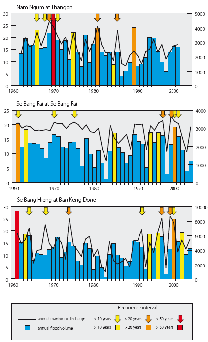
Figure 19. Time series of annual flood volume and peak discharge for selected right bank tributaries in Lao PDR.
Figure 19 shows the times series of annual flood peak and volume for three large left bank Mekong tributaries in Lao PDR:
- The data for the Nam Ngum at Tha Ngon clearly indicate the impact of the upstream reservoir on the flood regime. Since the dam was commissioned in 1971 only two significant flood events have occurred, while the most extreme regional flood events in recent regional hydrological history, those of 2000 and 2001 are not evident. Such impacts upon and scale of change to the downstream flood hydrology may be anticipated more widely as more reservoirs are developed regionally.
- Elsewhere, the evidence suggests that the tributary flood hydrology is broadly concordant with no significant events at during the 1980s and early 1990s followed by the events of 2000, 2001 and 2002, which dominate the regional picture.
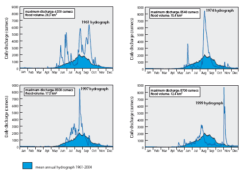
Figure 20. Se Bang Hieng at Ban
Keng Done (catchment area: 19,400 km2). Annual flood hydrographs
of 1961, 1974, 1997
and 1999, indicating the highly variable nature of the annual
flood regime and that between flood peak and volume.
- Other notable regional tributary events were those of 1961, 1974, 1997 and 1999. In comparing these four annual flood hydrographs, as in Figure 20 for the Se Bang Hieng, their highly variable nature from year to year becomes apparent, as does the often inconsistent relationship between flood peak and volume. The regularity of flash flood conditions, even within a very large catchments also emerges.
- The event of 1961 combined an exceptional 50 year flood volume with a series of peak flows, none of which exceeded a magnitude to be expected once in five years.
- On the Se Bang Hieng the flood season usually begins in mid June and extends to the end of October. During 1974 it got off to a false start during June but sustained flood flows did not begin until mid August. The flood season also ended a month early in the last week of September. It was therefore short and the volume of floodwater low. In the mean time the peak discharge reached almost 8500 cumecs, expected once on the average in 25 years.
- This type of flash flood hydrograph, from a catchment of almost 20,000 km2 is even more evident during the flood of 1997, when discharges increased four fold over less than a week also to 8500 cumecs.
- The most remarkable seasonal hydrograph is that of 1999, when to all effect the flood season ended two months early at the end of August. Then during November, outside of the usual flood season, a severe tropical storm caused a massive increase in flows over two days from less than 500 cumecs to 8700 cumecs and the classic flash flood hydrograph.
This highly variable flood hydrology both within and between years is characteristic of the large left bank tributaries and there is, in effect, nothing that can be defined the typical flood season hydrograph. Extremely rapid increases and decreases in flood discharge, generally associated with severe tropical storms can, even on very large catchments, cause flash flood conditions. Due to the flat landscape, the lower rainfall and to some extent the presence of large reservoirs, flash floods are not a feature of the hydrology of the Mun-Chi Basin, except in the far upstream reaches. Historically, the events of 2000, 2001 and 2002 dominate, both in terms of flood peak and volume (Figure 21), as they do elsewhere in the LMB. On the Nam Mun the highest peak discharge occurred in 1978, corresponding with the year that the largest flood peak was observed on the Mekong mainstream at Kratie since records began in 1924.
The evidence from the Nam Chi Basin suggests that below normal flood years, when peak and volume are significantly less than average, tend to cluster. During the 13 years between 1967 and 1979, eight of the most extremely deficient annual floods were observed.
With a total basin area of 120,000 km2 , equivalent to 22% of the Mekong drainage area at Pakse, the Mun-Chi contributes only 10% to the average flood volume at that point on the mainstream (Figure 22) and 6% to the total at the delta. It is never the less a key tributary system within the context of the flood hydrology of the Mekong, though overall the contributions of the left bank tributaries dominate:
Table 7. Mean annual tributary contributions to the Mekong flood.
| China (Upper Mekong) | Lower Mekong | ||
| Left bank tributaries | Right bank tributaries | ||
16% |
60% |
24% |
|
 |
||||||||||||||||||||||||||||||||||||||||||||||||||||||||||||||||||||||||||||||||
| Figure 21. Mun-Chi — Scatter Figure 21. plots of the joint distribution of the annual maximum flood discharge (cumecs) and the volume of the annual fl ood hydrograph (km3). The ‘boxes’ defi ne 1 and 2 standard deviations about the mean of each of the two variables, outside of which the annual fl ood is described as signifi cant and severe, respectively. | |||||||||||||||||||||||||||||||||||||||||||||||||||||||||||||||||||||||||||||||||

Figure 22. Mun-Chi Basin - Annual
flood contributions to the Mekong (km3),
also expressed as a percentage of the annual mainstream flood
volume at Pakse (1966 2007).
The central role that these major tributaries play in the development of the annual flood becomes apparent from Figure 23 which indicates the cumulative volumetric accumulation of the 2000 flood along the Mekong mainstream downstream of Chiang Saen, expressed in percentage terms. The inputs of the largest tributaries, which include the Nam Ou upstream of Vientiane and the Se Kong, Se San and Sre Pok system downstream of Pakse, are evident as successive sharp increases in mainstream flow:

Figure 23. Mekong mainstream
the cumulative development of the 2000 flood event downstream
of Chiang Saen, expressed in percentage terms.
- The Se Kong, Se San and Sre Pok system makes by far the largest contribution, amounting to 18%, exceeding that from the Upper Mekong in China. It is the pivotal element in determining the severity of flooding and inundation on the Cambodian floodplain and in the Mekong Delta, as indeed it was during the events of 2000.
- Tributary contributions during regional flood events such as this tend to replicate the average seasonal accretion of floodwater along the mainstream. Each of the major tributary systems tends to contribute a similar relative proportion of the overall flow from event to event.
- There are, however, periodic exceptions. The flood of 1966 provides the principal one when most of the floodwater originated in the Upper Mekong Basin and the northern Lao PDR and Thai tributaries.
- The tributary flood hydrographs during an extreme regional event such as that of 2000 can be quite dissimilar, as they reflect the hydrological consequences of catchment scale, the influence of landscape factors and the attenuating effect of large reservoirs.
- These dissimilarities are evident from Figure 24. Though they are very large tributary basins, the Nam Ou, Nam Kading and Se Bang Hieng still exhibit large but short term fluctuations in discharge. Flash floods conditions are not therefore confined to the smaller steeper river basins in the region.
- As catchment scale increases even further these relatively rapid variations in flow are smoothed out as the longer duration responses to each storm episode coalesce, resulting in the highly coherent and smoother hydrograph of the Se Kong, Se San and Sre Pok.
- Geographic scale is also a factor in the smoother flood hydrograph for the Mun-Chi, though here the flat landscape is also an influence.
- In the case of the Nam Ngum, the large reservoir storage in the basin screens out any short term fluctuations in flow.
- The six hydrographs also differ in the timing and number of flood peaks reflecting the geographical variability of the seasonal storm rainfall and the various tracks and impacts of the tropical storms. The 2000 flood on the Mekong mainstream was therefore the result of an accumulation of very distinctive tributary hydrographs.

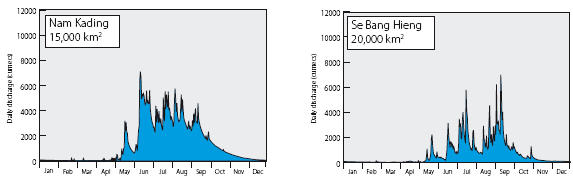
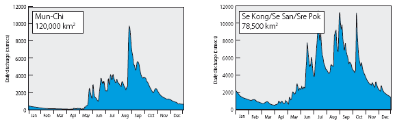
Figure 24. The distinctive hydrographs
of the tributary flows of 2000, illustrating the various impacts
on their pattern
of catchment scale, landscape factors and the attenuation of
reservoirs. The variability of the timing and number of
peaks amongst them also points to the geographical variability
of storm rainfall during 2000.
Choose a newsletter: