Background
The Caspian Environment Programme (CEP) is a regional umbrella programme established by
the Caspian littoral states and aided by international agencies. Born out of desire for
regional cooperation, expressed through a number of regional agreements, including
theAlmaty Declaration on Environmental Cooperation of May 1994, the CEP was agreed to in
June 1995 during a joint mission by the World Bank, United Nations Environment Programme
(UNEP), and United Nations Development Programme (UNDP). This mission marked the start of
a close partnership between the region and the international community. The mission also
cemented the collaboration mechanisms between the GEF implementing agencies.
As it now stands, the CEP is a regional programme that
encompasses all Caspian States and numerous international agencies, including the World
Bank, UNEP, UNDP, the European Union/TACIS (EU/TACIS), and many others. During meeting
held at Ramsar, Islamic Republic of Iran, in May 1998, the CEP was launched officially. A
steering Committee has been established, and the Caspian littoral states agreed that the
concept paper produced during the previous year in collaboration with the World Bank would
form the basis for the CEP. In addition, UNDP-led efforts towards a Global Environment
Facility (GEF) project for the Caspian focusing on its priority transboundary issues was
endorsed by the Caspian littoral states.
The endorsement of the Caspian Environment Programme
UNDP/GEF project occurred in October 1998 and a portion of the funds was released by
UNDP/GEF under Advance Authorization in April 1999. EU/TACIS funds were released beginning
in 1998.
Based on Advance Authorization by the UNDP in May 1999,
Activities in the UNDP –supported themes have been commenced since May 1999. These
themes include three in IR-Iran, which one of them was Effective regional Assessment of
Contaminant Levels (ERACL).
According to the EARACL WORK PLAN, one of the major ERACL
theme activities among its responsibilities is to carry out limited regional assessment of
contaminants to fill key gaps in Transboundary Diagnostic Analysis (TDA). In addition to
that, training of the regional expert in ambient monitoring and assessment was another
activities in this respect, which eventually the implementation of these tasks will
improve the regional capacity for ambient monitoring and assessment of contaminants,
especially in the Caspian Marine environment
In order to cover the above-mentioned tasks, the At Sea
training Programme ASTP, has designed to carry out a combined pilot monitoring and
training programme in the Caspian Sea using suitable vessel, on-board
equipment/instruments and on - land high qualified laboratory for contaminants
measurement. The present programme will be conducted under the responsibility of the theme
for Effective Regional Assessment of Contaminant Levels (ERACL). This work mainly will
fill in gaps that exist in our knowledge of regional monitoring and assessment. Finally,
the outcome of the ASTP programme will be utilized for the preparation of the TDA report
1-Objectives:
The major objectives of the At Sea Training Programme
(ASTP) are summarized as follows
Carry out a pilot ambient monitoring activity in the Caspian Sea in
order to create an up to date high quality contaminants data, to fill the gaps and serve
as supplementary inputs to TDA, SAP, and NAPs.
Determine the fate of contaminants, mapping the distribution and flux of
major contaminants (oil and non-oil) in water, suspended particulate matter, bottom
sediment and biota in the Caspian Sea marine environment.
On-Board training course for the region on ambient pollution monitoring
including methodology, sampling, sample handling and preservation, sample analyses,
quality control and data management.
In addition to the above-mentioned objectives, limited
study on spatial-temporal variability of the physical characteristics of the coastal water
mass using CTD and current meter data can be included.
2-Scope of the work
2-1-At Sea
The scope of the work comprises a series of activities and tasks including contaminants
studies, oceanographic observation and measurements. The details of the work will be
subject to some modification depending on various inputs, which may be provided by the
experts both from region or international bodies. In this section the general area of
activities regarding the sampling, observations and parameters are summarized and
presented. Details of each disciplines also presented in corresponding annexes.
2-1-1-Contaminant studies
This study will include the sampling and determination of the following:
Tonal Petroleum Hydrocarbons TPHs, including Polynuclear Aromatic
Hydrocarbons PAHs, in sediment and selected biota
Chlorinated hydrocarbons CHCs (DDT and its derivatives, Lindane,
Dieldrin, etc and PCBs in sediment and selected biota
Trace Metals TMs in sediment and selected biota as well as methylmercury
in biota
Determination of nutrient in seawater including Nitrate, Nitrite,
Phosphate, Silicate and Ammonia in water column
Detail of sampling methods , procedures and the parameters
are presented in Annex. I
2-1-2-Oceanographic parameters
This study will include the observation; measurement and determination of the following,
but the extent of oceanographic measurements depend on the availability of necessary on
–board facilities:
Standard meteorological measurements i.e. temperature, wind speed and
direction, relative humidity, atmospheric pressure, and etc.
Water temperature and Conductivity/salinity (T-C/S) will be measured
using CTD from surface to bottom.
In-situ measurements in water column i.e. Dissolved oxygen, pH, and
turbidity will be carried out if the suitable CTD with necessary sensors are provided.
In-situ current measurements will be carried out by means of an Acoustic
Doppler Current Profiler (ADCP), if is provided.
On-board Chlorophyll a, measurement in water sample will be made using
spectrophotometer
Suspended particulate matter (SPM) will be measured using filtering
system
Sediment grain sizes analyses
Total Organic Carbon in sediment
Mineralogy of the sediment (optional)
Others if the facilities are provided
Detail methodology of above mentioned studies presented in
Annex. I
2-1-3-Remote sensing studies (optional)
This part of the study could be included to the At Sea Training Programme in order to
improve the ability of region for monitoring and assessment of the Caspian Sea marine
environment. The major area of activities or goals could be summarized as follows:
Synchronization of available satellite remote sensing data with in-situ
measurements of the parameters of sea surface during ASTP implementation
Validation of multi level aero space remote sensing image data with
estimated retrieved during the ASTP performances
Demonstration of the use of remote sensing as a practical tool for
characterization and monitoring of the marine and coastal environment
Assessment of the ability of the existing remote sensing systems and
possibilities of introducing technologies to address the specific needs of the Caspian Sea
Identification of systems required to monitor the main sea surface
variables in the region
The in-situ measurements for selected study area will be
synchronized with satellite time tables (if possible). It will include Meteorological
parameters, Seawater spectral characteristics, sea surface temperature, sea surface
phenomena i.e. Oil spills, Algal bloom and etc.
2-1-4-Duration and the schedule
A total of 4 vessels may be neede, 3 vessels may need for the Northern part, covering the
Russian and Kzakistan area which mainly characterized with shallow waters (Leg-IA & IB
and II), and the forth vessel to cover the rest part of the Caspian Sea which is deeper
(Leg-III). The Leg-1 needs to be divided in two sub legs, Leg-1Aand Leg-1B. In this case
one suitable Russian vessel will cover the most shallower waters (Leg-1A), and the second
Russian vessel will perform the rest, which is deep part of Russian waters ( Leg-1B). Leg
II will cover the shallow part of KZ waters using OKIOC oil company appointed vessel. A
suitable large R/V vessel will cover the main part of the Caspian Sea including KZ
deep water, AZ, TURK and IR-Iran coastal waters. The total duration of the fieldwork
estimated to be approximately one month.
Leg-1 and II are planned to be started not later than 10
October 2000 before icing the northern shallow waters area. The Leg-IIIwill be carried out
in parallel with the Leg-I during 7-31 October 2000. A two-day on job training on the
vessel also planned to be held in Baku coastal waters with participation of all chief
scientists, the trainees from Caspian littoral states and international consultants as
well.
Based on the primary data concerning the number and
specification of needed vessels, availability of suitable vessels, and minimum time needed
for getting the vessel entry permission to the member states territory, the most
appropriate schedule was established and presented in the following table:
Table.1: ASTP training course & cruise schedule
Date/ Duration |
Activities/Cruis Leg |
Place of work |
Vessel to be used |
Remarks |
08/10/2000( one day) |
Workshop |
PCU, Baku |
none |
Presentation by chief
scientist and open discussion |
08/10 to 09/10/2000 ( 2
days) |
On job training using on
board facilities (Leg- III) |
AZ coastal waters |
R/V Gadgiev |
Sampling, sample handling and
preservation , in-situ measurements, on board laboratory analyses will be made |
10/10 to 31/10/2000 (22
days) |
Sampling , observation and
measurements ( Leg- III) |
Whole Caspian Sea, except for
Northern shallow water |
R/V Gadjiev |
Sampling, sample handling and
preservation , in-situ measurements, on board laboratory analyses will be made |
12/10 to 21/10/2000 (10
days) |
Sampling , observation and
measurements( Leg- IA) |
Western of northern part of
Caspian Sea ( Russian waters) |
Russian vessel |
Sampling, sample handling and
preservation , in-situ measurements, on board laboratory analyses will be made |
21/10 to 30/10 2000 (10
days) |
Sampling , observation and
measurements ( Leg-IB) |
Deep part of northern part of
Caspian Sea ( Russian waters) |
Russian vessel |
Sampling, sample handling and
preservation , in-situ measurements, on board laboratory analyses will be made |
Mid October 2000 (10 days) |
Sampling , observation and
measurements ( Leg-II) |
Eastern part of Northern
Caspian shallow water( KZ waters) |
OKIOC appointed vessel |
On board laboratory analyses
and sampling will be made. The exact date and duration are under negotiation with OIKIOC
oil company |
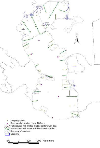
2-1-5-The area and sampling stations
a. Contaminant studies:
The sampling will be carried out both in major hot spot area as well as the intermediate
stations in between along the shoreline of the Caspian Sea. Few numbers of the hotspot
area have investigated recently by various authorities mainly oil and gas companies, which
their up to date data and information may be available to some extent to the ASTP
programme. Also there are some hotspot sampling area where the data are not existed or may
not be available. More sampling stations will be allocated for hotspots area, especially
for those where the available data and information are limited or not existed. Sampling
will be performed in shallow area to the maximum depth of approximately 50 meters. Limited
stations will be sampled to the maximum depth of 100 meters (total of five stations). As
mentioned above, intermediate stations also will be sampled along the shoreline with
larger spacing to compare with hotspot area covering the whole Caspian Sea coastal shallow
water. A total of approximately 100 stations finally will be sampled. If time allows, the
number of the sampling stations could be increased accordingly and will be decided on the
board. Proposed area and stations are shown in fig.1. List of the stations are presented
in Anne.II
b. Oceanographic parameters: A total of
approximately 25 transects perpendicular to the coastline to the maximum depth of 200
meters, about 3 stations in each will be profiled by CTD and ADCP (Fig.1 and Annex.II ).
Oceanographic parameters will be made following at the same stations for contaminants
studies.
2-1-6-On-board facilities
A suitable vessel with the ability of sampling in shallow water is the prerequisite of the
ASTP implementation. The major needed on-board facilities including the basic equipment
are presented bellow:
- Suitable winch and frame (for deep water to the maximum depth of 200 meters is suitable)
- Radar and GPS system for navigation. Computer could record the GPS out put.
- Suitable and sufficient rooms for accommodation of approximately 15-20scientists (only
for Leg-II)
- Suitable laboratory space equipped with basic facilities for chemical analyses
- On-board standard meteorological station with necessary sensors.
- CTD system for water temperature and conductivity/salinity measurement. In addition to
T-S, the DO, Ph, Turbidity sensors also will be suitable, if provided.
- Acoustic Doppler Current Profiler (ADCP)
- Auto analyzer or Spectrophotometer for nutrient measurement
- Filtration system for SPM Measurement
- Grab sampler
- Deep freezer –20C
- Teflon coated 5-10 liters Niskin bottles
- Spectrophotometer for chlorophyll measurement
- Secchi disc
- Computer facilities for on-board data transmission, processing and management
- Various containers for sample preservation (to be listed in detail)
- Reagents for chemical analyses and sample preservation
- Others
The full inventory of equipment, instrument, supply and
materials, concerning the requirements of each disciplines presented in Annex. III
2-1-7-On-boar data management/data sharing policy
An on-board data management system will be developed
preferably with a simple GIS support system. The management system will follow the
guidelines, that has been developed in Annex I as well as QA/QC section Annex.I.
The ASTP data and information will be owned by CEP and
other co-fonder as described below:
a. Data preparation: All final processed
data will be collected at the PCU. Data will be transferred to the PCU as raw and ASCII
files on 3.5 inches floppy diskettes or CD-ROMs (or via Internet for small data sets). The
precise format for different types of data is given in Appendix ?? All data must be
supplied with full metadata and information about the originators, methods used, and
instruments, quality control, problems and errors, etc. The data collection mechanism and
deadline for the data submission will be specified later by the ASTP Task Force team.
The CTD data sets will be provided in 1 m (db)
bin-averaged form of depth (pressure), temperature, salinity, and density (and other
variables according to the available set of sensors). Data for shallow stations (< than
20 meters) will be provided in non-averaged form at the highest depth resolution.
A workshop will be planned at the deadline of the data
processing (to be determined in the detailed cruise plan) to pool all the individual data
sets, carry out a cooperative and synthetic scientific analysis, prepare the final cruise
report, and discuss possible data application.
b. Data sharing: All data will be kept at
the PCU and used for TDA preparation. One copy of the full, pooled cruise data plus
interpretation will be made available to the NFP of each country and funding entities. Two
years following data pooling, the complete data set will be considered common property of
the funding and participating institutions, including the CEP.
c. Publications:A series of joint
publications using the collected data will be produced within the first two years. In
particular, these data will form the basis of the ERACL theme, and consequently the TDA.
All publications will bear the name of the scientists who were actively involved in the
data collection/processing stages of the ASTP cruise. Full acknowledgment of the data
originators, PCU, and funding organizations will be provided in each publication.
2-1-8- training programme
a .Area of training: This part will include the
training courses on designing of stations, sampling methodology, sample handling and
preservation for laboratory analyses, On-board oceanographic observation etc. Annex.I
alsowill serve as training reference materials too.
b. Participating trainees: A maximum of tow
or three trainees will participate from each Caspian Littoral States in ASTP training
programme. The training will be conducted during two day at sea training workshop at Baku
before the cruise to start.
2-2-Land-based laboratory analyses
All samples will be dispatched to the qualified laboratory or laboratories for analyses.
Detail parameters will be determined according to the available budget. Limited duplicate
samples will be delivered to the interested/recommended Caspian member states laboratories
for analyses. Participation of the littoral states laboratories in the analysis of the
sample will be coupled with inter comparison/ inter calibration exercises which is a part
of ERACL task for evaluation of the existing laboratory in the region. Laboratory analysis
methodology and references provided in Annex.I
Fig 1:
3-Annexes:
Annex. I: QA and On- board observation, sampling, analyses and sample
handling methods (physical, chemical and biological parameters, as well as remote sensing
studies)
Annex. II: The station coordinates & distances
Annex. III: Full inventory of on-board equipment, instrument, supply and
material
|
Meeting
Reports
Progress Reports
Up-coming Activities
    
|