3. The 2006 Flood Season
3.1 Hydrological and meteorological aspects
It has already been established that, from a hydrological perspective, flood conditions along the mainstream during 2006 were geographically quite variable.
- At Chiang Saen and Vientiane the flood peak of 16,800 cumecs on the 13th October was the second highest observed since 1960, while the flood volume was below average (Figure 9).
- At Kratie, the fourth lowest flood peak since 1924 was observed, while the flood volume was also significantly below normal (Figure 9).
- Throughout the mainstream, the onset and duration of the flood season was quite characteristic.
The daily discharge hydrographs for 2006 are illustrated in Figure 15, the key feature of which is the second peak and the fact that, without it, flood conditions would have been much very below average, particularly at Kratie.


Figure 15. The 2006 daily discharges
observed at Chiang Saen,
Vientiane and Kratie, compared with the long term mean daily
discharge hydrograph.
This picture of generally below average conditions, specifically from a volumetric viewpoint, is confirmed from an examination of the 2006 flood season flow duration curves (Figure 16), which show the percentage of time that a given discharge was exceeded.


Figure 16. 2006 flood season daily discharges
observed
at Chiang Saen, Vientiane and Kratie,
compared to their historical range and average.
- At Chiang Saen discharges were consistently below average until the arrival of the extreme flows associated with the October peak, which caused a sharp upturn at the high discharge/low exceedance probability end of the curve. The sharp rise in water levels upstream at Jinghong in Yunnan during early October which explains this very rapid but short lived peak at Chiang Saen is indicated in Figure 17.
- At Vientiane the distribution of the flood season discharges is entirely average.
- At Kratie the picture is of very much below average discharge magnitudes, resulting in a flood hydrograph volume 25% below normal. As can be appreciated from Figure 14, only during October were flows above average during the flood season, such that without the second peak overall volumes would have been extremely low.
Overall, these results indicate that during 2006 the peak discharge thresholds that were exceeded for any length of time were unexceptional. Only at Chiang Saen were severe flood discharges and water levels exceeded, though only briefly.

Figure 17. Water levels at the Mekong
mainstream at Jinghong on
Yunnan Province, China; 1stSeptember to 15th October 2006.
The peak
water level occurred on the 11th October.
The 2006 monsoon was generally rather weak overall, which is reflected in the hydrology of the flood season. Three major tropical storm systems tracked across the Mekong Basin during the year; their tracks and associated rainfall are presented in Figures 18 to 20:
- During the last week of August Tropical Storm Prapiroon entered the region as a tropical storm, but was quickly downgraded to an intense tropical depression as it weakened. Intense storm rainfall (150 to 200 mm) was confined to northern Thailand, northern Lao PDR and eastern Cambodia. This system was responsible for some severe tributary flash floods in northern Thailand, particularly on the Nam Mae Kok at Chiang Rai.
- Severe Tropical Storm Xangsane moved into the central and southern parts of the region during the first week of October. The rainfall and flood runoff associated with this system were responsible for the second peak to the annual flood hydrograph, already discussed in detail. Significant storm rainfall was widespread (Figure 19), particularly towards the south. To the north in Yunnan rainfall in the week exceeded 150 mm, which in part explains the extreme but brief October peak to the flow hydrograph at Chiang Saen and the very rapid rise in water levels at Jinghong (Figure 15 and Figure 18).
- Tropical Storm Durian was not linked to widespread rainfall during its passage over the Viet Nam Delta during the first week of December (Figure 20), but principally with very high wind speeds and a storm surge which caused extreme sea levels and widespread inundation and damage as a result.


Figure 18. Tropical Storm Prapiroon, moved in over the Upper Mekong Basin during the last week of August, 2006, but rapidly weakened to become a tropical depression. Intense storm rainfall (150 to 200 mm) was confined to northern Thailand and eastern Cambodia.

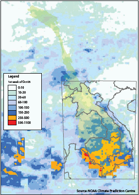
Figure 19. Severe Tropical Storm Xangsane, moved in over the Central Mekong Basin during the first week of October, 2006. Very intense storm rainfall (250 to over 500 mm) was widespread over southern Lao PDR, Cambodia and Viet Nam.p


Figure 20. Tropical Storm Durian, moved in over the Mekong Delta in Viet Nam during the first week of December, 2006, but rapidly weakened to become a tropical depression. The associated rainfalls for the week were generally less than 100 mm.
3.2 The 2006 flood season: conditions over the Cambodian floodplain and in the Delta in Viet Nam

Figure 21. Cambodian Great Lake.
Annual maximum
water levels observed at Kampong Luong.
The generally below average magnitude of the mainstream seasonal flood hydrograph during 2006 carried over into the Cambodian floodplain and the Mekong Delta in Viet Nam, where seasonal maximum water levels were similarly below normal. This apparently did not apply to maximum water levels achieved in the Tonle Sap/Great Lake system, however, where as Figure 21 illustrates the 2006 maximum water level was only a few centimetres less than that achieved in 2000, an extreme flood year which led to the largest regional loss of life and socioeconomic damage witnessed in recent decades.
The 2006 maximum was observed on the 14th October and was a clear response to the storm rainfall and second peak to the regional flood hydrograph associated with Severe Tropical Storm Xangsane. As Figure 19 clearly shows most of the excessive rainfall generated by this system was confined to eastern Cambodia and the Great Lakes own system of tributaries, which would have caused significant volumes of local runoff, given that during the first week of October these areas received 400 to 500 mm of rainfall. Three other factors contribute to the fact that the 2006 maximum lake level almost matched that of 2000:

Figure 22. Comparison of the spatial
extent of floodplain
inundation over the Cambodian. Floodplain and the Mekong
Delta for the years 2000 (delimited in yellow) and 2006
(area shaded blue).
- The second peak on the Mekong mainstream in early October occurred when the Lake was close to its highest seasonal level and would have caused increased inflow to the Tonle Sap. Water levels therefore rose above what otherwise would have been their highest levels for the year.
- The 2000 flood and its impacts are largely explained in terms of exceptionally high volumes and the duration of the regional inundation. The peak was average (refer to Figure 9) such that the annual maximum level of the Great Lake level that year was not as extreme as the flood impacts might imply.
- Maximum annual levels in the Great Lake are largely bounded, in so far as the landscape is extremely flat, so water spills out over the floodplain and moves transversely. Physically therefore, water levels are limited vertically as excess water moves out over the landscape.
In the face of these factors therefore, the extent of flood inundation over the Cambodian floodplain in 2000 and 2006 were quite similar, as Figure 22 confirms.
Downstream from the Great Lake itself, at Prek Kdam on the Tonle Sap river and at Phnom Penh Port on the Mekong mainstream, the maximum water levels for 2006 were much closer to average, though only three to four centimetres lower than the maximum observed on the Great Lake. They were, however, much less than those observed during the 2000 flood at each of these sites (Figure 23). Quite why this should be so, when the level of the Great Lake in 2000 and 2006 were so similar, is not entirely clear, but the fact that the rainfall over the Great Lake basin and its tributaries was so extreme due to Severe Tropical Storm Xangsane, may go some way towards an explanation.

Figure 23.Annual maximum water
levels for 2006 at Phnom Penh Port and
Prek Kdam in their historical context. They were average and
in 50% of years
they would have been exceeded.
Over the Delta in Viet Nam the total area inundated in 2000 was much greater than during 2006, as can be seen from Figure 22. Maximum water levels for the year were marginally below average, as the data for Tan Chao and Chao Doc confirm in Figure 24. As regards the timing of these annual maximum water levels, they were two weeks later than normal at all sites in these floodplain and delta regions, as illustrated in Figure 25.
Figure 26 summarises these downstream water levels for 2006. The maxima for the year were above the average for the day on which they occurred, but only marginally so. The fact that they occurred two weeks later than average is confirmed.
This moderate to below average flood regime in the Delta during the year meant that direct flood damage was not severe. However, the late appearance of flood peaks did bring about some unfavourable conditions for agriculture. What widespread inundation there was occurred when high tides combined with incoming flood flows from upstream, which occurred three times during August and September. The associated water levels at most stations were higher than alert level 3 over a duration of one to three hours, though actual inundation was often longer due to poor drainage capacity (VNMC 2006 Annual Flood Report).


Figure 24. Annual maximum water levels for 2006 at Tan Chao and Chao Doc in their historical context. They were average and in 65% of years they would have been exceeded.

Figure 25. Historical (1980 2006) probability distribution of the date of occurrence of annual maximum water level at Prek Kdam, Tan Chao and Chao Doc, which 50% of the time would be expected to occur not later than the beginning of October. During 2006, its occurrence was atypically late, since maximum water levels were not observed until the latter half of October.

Figure 26. Long term distribution of daily water levels at Phnom Penh Port, Prek Kdam, Tan Chao and Chao Doc, the historical average onset and end dates of the flood season and the comparative magnitude of the maximum water levels reached in 2006.
Choose a newsletter: