6. Thailand 2006 Country Report
6.1 General situation
During 2006 Thailand was badly affected nationwide by floods from several storms, most particularly from Severe Tropical Storm Xangsane (which turned into a tropical depression in the country) and Tropical Storm Prapiroon. Out of 75 provinces, 46 were locally inundated. According to the Ministry of Public Health, the most affected provinces were Phra Nakhon Si Ayuttaya (South Central Region), Nakkon Sawan (Eastern Thailand and within the Mekong Basin) and Sukkothai. (Northern Region). Storms and local urban flooding in particular were a constant news feature from May onwards.
By mid-October, Thailand’s Department of Disaster Prevention and Mitigation (DDPM) reported that 47 people had been killed, two were missing and more than 2.4 million people were affected to various degrees over the country as a whole (see Appendix 7). According to the Ministry of Education, a total of 378 schools in 21 provinces were affected, of which 310 were closed for significant periods of time. Approximate losses are estimated to be of the order of US$8 million (United Nations Office for the Coordination of Humanitarian Affairs, UNOCHA).
6.2 Specific events
In 2006 the rainfall intensity in May and October was the highest for 30 years.
At the beginning of August Tropical Storm Prapiroon passed over the South China Sea to the northern part of Thailand and created heavy rainfalls in the north, northern central region, the north east and the east coast of Thailand.
From 19th to 21th August the strong low pressure that passed over the northern and northeastern part of Thailand produced intense rainfall, this measured a maximum of 259 mm in Nan province and caused flash flooding of the Nan river. Water levels rose very quickly and created floods of 2–3 m at Amphoe Tha Wang Pha on the morning of 20th August, followed by 1–1.5 m floods at Amphoe Muang and Amphoe Phu Piang.
Between 27th August and 4th September a strong low pressure passed over the northern part of the country and brought heavy rainfall that caused water-levels in rivers in the Ping, Kuang, Tha, Yom and Wang river basins to rise very rapidly.

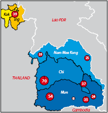
Figure 29. Flood affected areas
(km2).
Shortly after this (from 9th to 12th September and from 18th to 23th September) another strong low pressure cell passed over the northern and north eastern part of the country. This combined with the southwestern monsoon and low pressure in the Southern China to become Severe Tropical Storm Xangsane. This depression generated very heavy rainfall in the southern area of the northern provinces and the central part of the country, bringing with it fast rising water levels and floods in many areas.
Serious floods were experienced in the following sub basins of the Mekong River in Thailand in the year 2006:
- Kok river basin: There were major floods in Chiang Rai province and Pa-yaw Province. In Chiang Rai about 159,617 rai or 255 km2 was inundated, most of which was flat land located in Amphoe Muang, Maesai, Mae Chan, Pha Yam Eng Rai, Thueng and Padad. In Pa-yaw about 174,584 rai or 279 km2 was inundated in Amphoe Chun, Chieng Kam, Dok Kam Tai and Phu Kam Yao.
- Nam Mae Kong basin: One major flood occurred in Nong Khai and Udon Thani provinces with about 393,639 rai or 630 km2 inundated.
- Chi river basin: Major floods occurred in Chaiyaphum, Koonkaen, Masarakam, Roi-et and Yaso Thon provinces inundating about 1,271,814 rai or 2,026 km2.
- Mun river basin: Major flooding occurred in Nakhonrachasima, Buriram, Surin Srisakes and Ubon Rachathani provinces inundating about 2,101,470 rai or 3,362 km2.
6.3 Flash flooding in the Thai Mekong region and bordering provinces
Incessant monsoonal storm rainfall, particularly during August and September, caused flash floods in Chiang Rai and Nan provinces, with three people killed or missing. The flooding in Nan was reported to be worst in more than 40 years (Bangkok Post, 13/9/2006), with general depths of inundation of between 1.20 –1.80 metres. In Chiang Rai four schools were closed for indefinite periods and more than 5,000 villagers were badly affected.

Plate 5. Mid–August floods in Nan
Province caused many families to
retreat to the upper floors of their
houses.
Flash floods in mid August caused the flooding of 500 houses and the inundation of 5,000 rai of farmland in Chiang Rai province alone. The loss of crops and therefore income reportedly caused the temporary migration of many rural family members to Bangkok to find work (Bangkok Post. 13/9/2006). Provincial public health authorities reported that stagnant floodwaters were a constant threat to public health and leading to significant outbreaks of conjunctivitis and leptospirosis (The Nation, 15/9/06).
An additional hazard associated with flash floods, particularly in the steeper landscapes of Chiang Rai province for example, are mud slides which annually threaten many villages. These not only threaten to cut rural communities off during times of flood emergency, such that relief aid cannot get through, but in many cases they threaten rural life and property directly. The prevalence of land and rock slides under saturated conditions during storm rainfall should be perceived as an integral part of the flash flood hazard, as they often temporarily block rivers and streams, are then over-topped, collapse and can release an extremely destructive flood wave.
6.4 Damages and costs

Figure 30. Cost of serious damage
from
flooding during 2006 (million baht).

Figure 31. Example (draft) of the
mitigation process in an agricultural area.

Choose a newsletter: