7. Viet Nam 2006 Country Report
7.1 Conditions over the Se San and Sre Pok River basins
Within these river basins the onset of significant monsoonal rainfall was later than normal and resulted in some un-seasonally low water levels. Few tributary floods were observed, there being only two of moderate magnitude:
- The mid August event (8th 17th) followed widespread heavy and very heavy rains over most of the Sre Pok river basin, with accumulated storm depths during the 10 day period of 150 to 200 mm generally and as much as 250 mm to over 400 mm locally. The corresponding flood discharges in the Sre Pok and its tributaries exceeded alert level 2.
- The event of early October event (5th 9th) which was in response to storms over the Central Highlands associated with Severe Tropical Storm Xangsane, with cumulative five day rainfall depths locally in excess of 180 mm. However, only low levels of flood alert were broadcast.
7.2 Flooding in the Mekong Delta

Plate 6. Tidally induced flooding
during August
and September 2006 in the lower Delta
(Dong Thap province).
At the start of the 2006 flood season, during the last few days of June, the rise in water levels in the Delta regions was extremely rapid, a fact which can be appreciated by referring to the 2006 Kratie discharge hydrograph in Figure 15. Initial peak water levels were reached in early September, with water levels of 3.9 masl and 3.4 masl at Tan Chao and Chao Doc respectively, though these were only of the order of the seasonal average (Figure 24). This initial peak was followed by 20 days of declining water levels, followed by an increase in response to the effects of Severe Tropical Storm Xangsane. This second peak marked the highest water levels attained for the year, these being 4.2 m on 17th October at Tan Chao and 3.7 m at Chao Doc a few days later on the 21st October, annual maxima which were no more than average (Figures 24 and 26). These annual peaks were two weeks later than usual, as has already been noted, such that late October and early November water levels remained higher than normal. At Tan Chao the flood alert level was exceeded for a period of 20 days and the flood level reached (see Appendix 5), which resulted in the widespread inundation of agricultural lands. Flooding in the Lower Delta regions during August and September was generally tidally induced and short lived, except in areas where drainage capacities were poor (Plate 6).
7.3 Flood damage
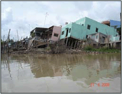
Plate 7. Severe to total structural
damage
caused by riverbank erosion and soil saturation
during flood conditions (Dong Thap province).
Due to the fact that flood magnitudes during 2006 were average, damage was not widespread, but it was locally significant. In the Sre Pok and Se San river basins, in Dak Nong and Dak Lak provinces, almost 1,400 properties were inundated, including one school, and 800 households had to move temporarily. Crops were damaged over a total area of almost 5,800 hectares, almost all of which were planted to rice paddy and coffee. Total (write-off) crop losses were not significant, however. Farm stock losses were small. Damage to infrastructure such as roads, bridges, dykes and irrigation channels was relatively widespread but not untypical of that for an average year. Considerable damage and loss was associated with Severe Tropical Storm Xangsane during the first two weeks of October, though much of this was the result of very strong winds which brought about structural damage, cash crop losses and disruption to transport and communication.

Plate 8. Damage caused by Tropical
Storm
Durian in the Mekong Delta during the
first week of December.
In the Delta regions there were 55 deaths recorded that were linked to flooding and storms. Of these 50 were children. Total damage was estimated to be US$15 million, a significant factor in which was property losses due to bank erosion during the flood season (Plate 7).
Major regional damage was brought about by Tropical Storm Durian during the first week of December, though most of this was the result of high winds and coastal storm surges and was not attributable to hydrological flooding or intense storm rainfall (see Durian rainfall map in Figure 20 and Plate 8). Over 6,000 households were urgently evacuated and more than 68,000 people moved to safe refuges.
7.4 Lessons learnt
During the course of Tropical Storm Durian, most local authorities were found capable of implementing official mitigation directives and successfully carried out the necessary measures such as household evacuation and the recall of vessels at sea. Less experienced authorities were identified and institutional strengthening will be undertaken. A particular measure that was recognised as requiring attention was the need to encourage the strengthening of the roofs of domestic properties in order to reduce wind induced damage, which was the most significant factor associated with the storm losses.
- On the whole the cooperation of the local people with the authorities was commendable, though there were exceptions in some districts. These were often the result of complacency brought about by a third consecutive year of average flood and storm conditions.
- Local budgetary limitations meant that deteriorated and damaged flood protection infrastructure has not been systematically maintained and promptly repaired. Priority new schemes are often delayed due to difficulties in ground clearance and the relocation of households.
- The permanent relocation of highly vulnerable households from high risk areas and those undergoing active flood erosion continues to be difficult. Residents in such localities generally have poor living conditions and are unconvinced that their livelihoods can be sustained or bettered unless the new infrastructure and facilities provided for them are clearly far superior to their current situation.
- Local Steering Board for Flood and Storm Control staff may hold several positions and have a wide range of responsibilities, making timely data collection and processing less effective in an emergency.
- Wave and wind protection for local infrastructure lags
behind that for hydrological
flooding, which as the damage from Durian illustrated, requires attention in order to
reduce the losses to national assets from tropical storms.
Choose a newsletter: