• DSF
Introduction
• System Components
• Using the System
• System Maintenance
Decision Support Framework
The Decision Support Framework is a PC-based system suitable for running on local area networks. In-built security systems restrict access to ensure that core data remain quality assured and intact.
The system is being set up in each of the four countries with a master copy at the MRC Secretariat. It is configured in a manner that allows local users to undertake their own analyses in private, to share these with others at their location when ready and finally to export these to other locations for others to review and verify. For the present, export to other locations will be by CD or DVD, but later on the DSF could be modified to make use of the internet when line capacity and speeds are improved.
Four level of access have been defined to enable appropriate use of the system according to user needs and capability.

Four levels of DSF users
- Manager/Planner - defines water resources development and intervention scenarios to be investigated with the DSF and who may view and export the results to review and compare scenarios
- System Operator - undertakes scenario analyses using preloaded data sets and models in the DSF's Knowledge Base, with scope for certain adjustments
- Modelling Specialist - responsible for setting up new model configurations (eg new structures) and datasets to load into Knowledge Base, where necessary recalibrating the models as new information becomes available
- System Administrator - responsible for the maintenance of the DSF, ie for incorporating system updates (new core data) and system upgrades (new software), managing access rights, passwords, etc.
Collaboration with scenario assessments
 |
Planning preparatory work
|
The immediate purpose of the DSF is to support the ongoing MRC programmes concerned with establishing water utilisation procedures and the Basin Development Plan. Nevertheless, the capabilities of the system are equally relevant to the activities of the other MRC programmes, which are directly or indirectly concerned with development of appropriate sub-sectoral strategies.
In all cases, the DSF is a toolbox that supports planning assessments and is fully complementary with the wider planning process. The fundamental use of the DSF, apart from its ready use as a general source of geo-referenced and quality assured information, is as a tool to conduct assessment of possible future circumstances and interventions, referred to as scenarios.
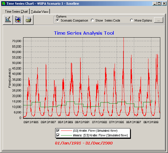
Demonstration Scenarios
- Nominal baseline
- Impact of climate change
- Impact of catchment cover change
- Impact of high irrigation demand
growth - Impact of upstream dams
- Impact of LMB dams
- Impact of flood embankments
In the context of the DSF, a scenario is defined by a specific combination of hydrological conditions, demands upon the system and interventions assumed to have been put in place.
The full process of scenario assessment requires the collaboration of both planners in the BDP and Interim Basin Flow Management teams and DSF operators and modellers in the Technical Support Division, as illustrated in the box above.
The DSF has been pre-loaded with seven demonstration scenarios to illustrate the range of analyses that can be undertaken.
These examples underscore the capability of the DSF to look into a wide range of future conditions in the basin and the impacts these are likely to bring about. Future users of the system can build on these examples or develop and test their own ideas of what might be needed to realise the goals of the 1995 Agreement.
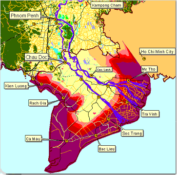
The DSF allows a wide range of reportage, in the form of maps, graphs and tables.
Results can be readily exported, for instance into spreadsheets for further analysis, or directly to report documents.
Users have complete freedom of choice as to how they wish to present the information to suit their own purposes.
The DSF provides users with a very substantial analytical capability to look into the issues that will help shape future management strategies and development choices.

E-Newsletters
Choose a newsletter: