

|  |  |
BALANCE – or in full "Baltic Sea Management – Nature Conservation and Sustainable Development of the Ecosystem through Spatial Planning" – was an INTERREG III B co-funded project aimed towards development of informed marine management tools for the Baltic Sea based on spatial planning and cross-sectoral and transnational co-operation. BALANCE, started in July 2005 and ended in December 2007. For more information about the project, see: http://balance-eu.org/about_us/index.html. As part of the project, BALANCE created a data portal which can be viewed via: http://maps.sgu.se/Portal/.
Below you can download several of the GIS datasets produced by the BALANCE project in zip-files. The datasets are in shapefile or raster format. You may read the metadata (at present this works best with internet explorer) and preview the images by clicking on the appropriate links following the dataset name. Note that some of the datasets are very large (the size of the dataset is indicated if it is larger than 1 MB).
Please note that the data source should always be cited when using the data. All details are included in the metadata attached to the shapefiles.
Download BALANCE produced dataset below
Baltic-wide datasets
Marine benthic landscapes (broad scale benthic habitats) (preview, view metadata) (NEW - added 19.4.2010)
;w.focus();)
Bathymetry of the Baltic Sea (preview, view metadata)
;w.focus();)
Model results showing the annual mean bottom current velocity (m/s) (40 MB) (preview, view metadata)
;w.focus();)
Model results showing the distribution of the photic zone (preview, view metadata)
;w.focus();)
Model results showing the bottom salinity field over the Baltic Sea (preview, view metadata)
;w.focus();)
Marine seabed sediments in the Baltic Sea (preview, view metadata)
;w.focus();)
Seabed slope derived from bathymetry map of the Baltic Sea (18 MB) (preview, view metadata)
;w.focus();)
Model results showing the average bottom temperature in the Baltic region in the plant growth season from April to September (2 MB) (preview, view metadata)
Average ice cover within the Baltic Sea region (5 MB) (preview, view metadata)
;w.focus();)
Modelled distribution of every year bottom oxygen depletion area for the entire period 2000-2006 (90 MB) (preview, view metadata)
.png', '_blank');w.focus();)
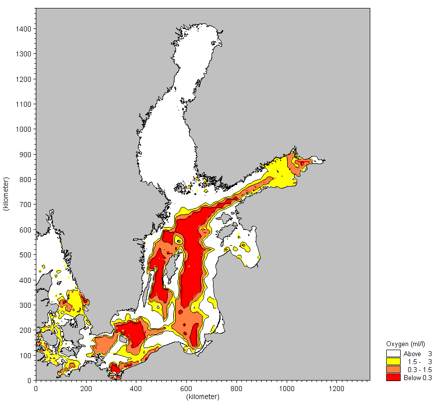
Modelled distribution of minimum bottom oxygen concentrations in the Baltic Sea for the entire period 2000-2006 (90 MB) (preview, view metadata)
.png', '_blank');w.focus();)
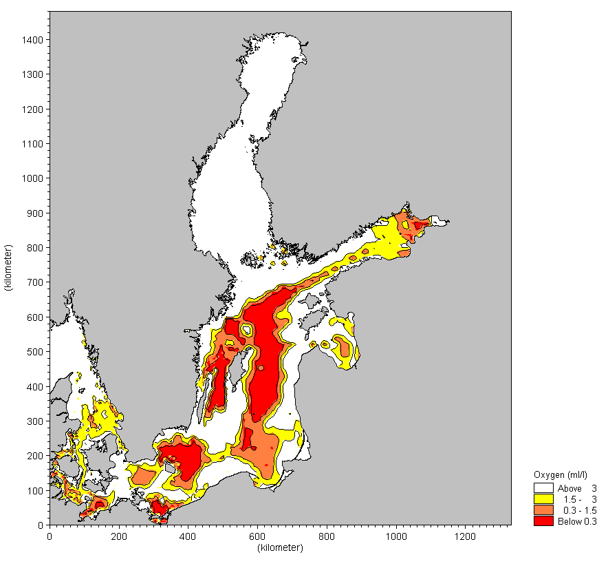
Modelled distribution of minimum bottom oxygen concentrations in year 2000 (90 MB) (preview, view metadata)
;w.focus();)
Modelled distribution of minimum bottom oxygen concentrations in year 2001 (90 MB) (preview, view metadata)
;w.focus();)
Modelled distribution of minimum bottom oxygen concentrations in year 2002 (90 MB) (preview, view metadata)
;w.focus();)
;w.focus();)
Modelled distribution of minimum bottom oxygen concentrations in year 2003 (90 MB) (preview, view metadata)
;w.focus();)
;w.focus();)
Modelled distribution of minimum bottom oxygen concentrations in year 2004 (90 MB) (preview, view metadata)
;w.focus();)
;w.focus();)
Modelled distribution of minimum bottom oxygen concentrations in year 2005 (90 MB) (preview, view metadata)
;w.focus();)
Modelled distribution of minimum bottom oxygen concentrations in year 2006 (90 MB) (preview, view metadata)
;w.focus();)
;w.focus();)
Archipelago Sea area
Degree of physical exploitation in the Swedish Archipelago Sea (7 MB) (preview, view metadata)
;w.focus();)
Major Harbours, industry and built-up areas in the Swedish Archipelago Sea (preview, view metadata)
;w.focus();)
Marinas along the Swedish Archipelago Sea coast (preview, view metadata)
;w.focus();)
Ocean in the Swedish Archipelago Sea (33 MB) (preview, view metadata)
;w.focus();)
Basic Environmental data in the Swedish Archipelago Sea (73 MB) (preview, view metadata)
;w.focus();)
Elevation along the Swedish Archipelago Sea coast (13 MB) (preview, view metadata)
;w.focus();)
Modelled distribution of Baltic Esker Islands in Swedish Archipelago Sea area (preview, view metadata)
;w.focus();)
Modelled distribution of Estuaries in Swedish Archipelago Sea area (preview, view metadata)
;w.focus();)
Modelled distribution of large shallow inlets and bays in Swedish Archipelago Sea area (preview, view metadata)
;w.focus();)
Modelled distribution of coastal lagoons in Swedish Archipelago Sea area (preview, view metadata)
;w.focus();)
Modelled distribution of coastal lagoons and gloes in Swedish Archipelago Sea area (preview, view metadata)
;w.focus();)
Modelled distribution of reefs in Swedish Archipelago Sea area (preview, view metadata)
;w.focus();)
Modelled distribution of sublittoral sandbanks in Swedish Archipelago Sea area (preview, view metadata)
;w.focus();)
Modelled distribution of Boreal Baltic islets and small islands in Swedish Archipelago Sea area (34 MB) (preview, view metadata)
;w.focus();)
Read about mapping of Natura 2000 Annex 1 Habitats in Sweden
Zonation of Finnish Archipelago Sea area (preview, view metadata)
;w.focus();)
Communication infrastructure in Finnish Archipelago Sea area (17 MB) (preview, view metadata)
;w.focus();)
Shoreline erosion induced by navigational activities along a segment of Turku-Stockholm deep lane (preview, view metadata)
;w.focus();)
Shoreline erosion induced by navigational activities along deep lane segments in Stockholm archipelago (preview, view metadata)
;w.focus();)
Marine noise disturbance from vessels in the Archipelago Sea area (preview, view metadata)
;w.focus();)
Habitat heterogenity in the Archipelago Sea area (preview, view metadata)
;w.focus();)
Potential dredging sites in the Archipelago Sea area (2 MB) (preview, view metadata)
;w.focus();)
Human influence on coastal lagoons in the Archipelago Sea area (3 MB) (preview, view metadata)
;w.focus();)
Effects of marine management activities on fishing in Archipelago Sea area (preview, view metadata)
;w.focus();)
Effects of recreational fishing on sensitive habitats in Archipelago Sea area (preview, view metadata)
;w.focus();)
Modelled distribution of perch young of the year in Archipelago Sea (15 MB) (preview, view metadata)
;w.focus();)
Modelled distribution of perch spawning habitat young of the year in Archipelago Sea (5 MB) (preview, view metadata)
;w.focus();)
Modelled distribution of pike young of the year in Archipelago Sea (7 MB) (preview, view metadata)
;w.focus();)
Modelled distribution of roach young of the year in Archipelago Sea (17 MB) (preview, view metadata)
;w.focus();)
Modelled distribution of sander young of the year in Archipelago Sea (8 MB) (preview, view metadata)
;w.focus();)
Read about fish habitat modelling in the Baltic Sea archipelago region
Latvian coast
Furcellaria stands along the Latvian Baltic Proper coast (preview, view metadata)
;w.focus();)
Skagerrak
Laminaria (preview, view metadata)
;w.focus();)
Nephros (13 MB) (preview, view metadata)
;w.focus();)
Last updated: 19 April 2010