Description of the HELCOM Marine Spatial Planning Tool
 In the HELCOM Baltic Sea Action Plan and HELCOM Recommendation 28E/9 the coastal countries and EC commit themselves to develop marine spatial planning in a way which allows all Contracting Parties and relevant HELCOM bodies to co-operatively participate. The goals are to give guidance for planning activities and ensuring the protection of the marine environment and nature, including habitats and seafloor integrity, as well as secure the sustainable use of marine resources by reducing user conflicts and adverse impacts of human activities.
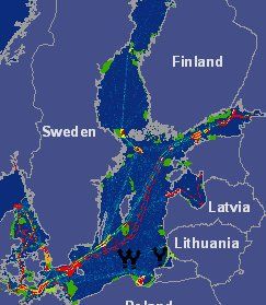
One part of the development of a functional marine spatial planning system is the stepwise creation of a targeted Geographical Information System (GIS) application, where relevant existing information on human activities and environmental parameters are collected for easy multi-layer map display and reference. The first step of this process has now been taken as the first (draft) version of an interactive web-based GIS interface for Marine Spatial Planning has been created by HELCOM. The interface is available at:
http://maps.helcom.fi/website/MSP_development/viewer.htm.
The map interface makes it possible for the users to view different datasets related to marine spatial planning and combine them together to create a multitude of different maps. These maps can then be printed or saved as images for further processing. The map view can be used for zooming in on the particular areas of interest, for identifying and searching features in the datasets, for viewing the details of certain features of interest, as well as for creating buffers around features and measuring distances. Metadata is provided for all of the datasets.
A “drafting tool” has been included, which allows the user to create marine spatial plans on the map, making use of all the other datasets as a background. The user can draw points, lines and areas on the map using different colors and symbols; name these features and add explanatory texts. The created drafts can then be saved and they can also be viewed by others. Users can also base their own plans on the plans of others, either with the aim to just comment on those plans or to create a parallel suggestion. The draft tool makes the GIS interface not only a place to view existing data and create maps based on it, but also a place to create, communicate and discuss marine spatial plans.
The map service currently includes datasets providing traffic and oil spill information (traffic density estimates, harbors, oil terminals and platforms, navigation routes, accidents and illegal discharges), information on ecologically important areas (Baltic Sea Protected Areas, Important Bird Areas, other sensitive areas), inland information (place names, cities, main roads, land cover classification, rivers an lakes) and marine information (territorial waters and EEZs, bathymetry) but the amount of available data is constantly growing. It is also possible to develop the functionality of the service further, providing more options for planning drafts, communicating and creating printouts.
The current service is created mainly using ArcIMS technology of ESRI and custom made Javascript and ASP-pages. The advanced printing options make use also of ArcGIS Server's REST API. The datasets are maintained in a relational database and the planning drafts in a MS Access database.
Go to the marine spatial planning interactive map-based tool
![]()
HELCOM SCALE project
This website has been created with the financial assistance of the European Union (HELCOM SCALE, Project 21.0401/2007/485831/SUB/D2). Any views expressed here can in no way be taken to represent the opinion of the European Union.
Last updated: 13 February 2009

