|
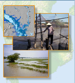
While many fisheries activities and aquaculture operations are carried out at a scale that usually escapes the watchful eye of satellites, there are some very instructive examples of how satellite imagery can be used to map fish habitat or to map large fishing structures along the Great Lake.
Land use and land cover changes are threatening areas that traditionally constitute fish habit during the dry and the wet season. Sequences of satellite imagery provide excellent overviews for local habitat assessment, regional land use planning and basin-wide monitoring of aquatic resources.
|