More information and download links below the graphic.
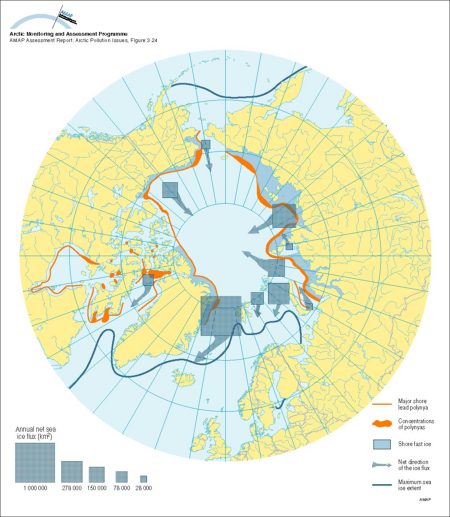
Approximate net sea ice exchange (see legend for key to arrow sizes), extent of shorefast ice and winter sea ice, and coastal polynyas and main polynya concentrations

Click here, or on the graphic, for full resolution.
Approximate net sea ice exchange (see legend for key to arrow sizes), extent of shorefast ice and winter sea ice, and coastal polynyas and main polynya concentrations
| Sources | Sources of ice flux data: Zakharov, V.F., 1976. Cooling of the arctic and ice cover of the Arctic seas. Trudy Trans. 337: 96. Vinje, T., 1987. Morphology and dynamics of the Barents Sea ice field. POAC 77, University of Alaska, Fairbanks. Aagaard, K. and E.C. Carmack, 1989. The role of sea ice and other fresh water in the arctic circulation. J. geophys. Res. 94(C10): 14485-14489. Kvambekk, A.S. and T. Vinje, 1993. The ice transport through Fram Strait. Paper presented at the Nansen Centennial Symposium, Bergen, Norway, 21-25 June, 1993. (unpublished). Kotchetov, S.V., I.Y. Kulakov, V.K. Kurajov, L.A. Timokhov and Y.A. Vanda, 1994. Hydrometeoroligical regime of the Laptev Sea. Federal Service of Russia for Hydrometeorology and Monitoring of the Environment, The Arctic and Antarctic Research Institute, St. Petersburg, Russia. manuscript, 85 p. shore-fast ice extent on Siberian shelf: after Buzov, A.Y., 1991. Natural factors and their influence on transit sailing on the Northern sea Route - Part I. The Northern Sea Route Project - Pilot Studies Report. The Fridtjof Nansen Institute, Oslo. (AAR Figure 3.24) | ||||
|
Cartographer/ Designer |
Graphical production: Philippe Rekacewicz and Emmanuelle Bournay (GRID-Arendal) | ||||
| Appears in |
AMAP Assessment Report: Arctic Pollution Issues |
||||
| Published | 1998 | ||||
| Feedback/Comment/Inquiry | Contact webmaster | ||||
| Search for other graphics |
With related subjects Covering the same geographic area |
||||
|
Available Downloads
(please review use constraints above) |
|
||||
|
Citation/Reference Use constraints |
Please refer to the AMAP policy regarding use and reproduction of AMAP maps and graphics |
