|
The Benguela: A unique environment
The Benguela Current region is situated along the coast of
southwestern Africa, stretching from east of the Cape of Good Hope in the south,
northwards to Cabinda in Angola and encompassing the full extent of Namibia’s
marine environment.
It is one of the four major coastal upwelling ecosystems in
the world which lie at the eastern boundaries of the oceans. Its distinctive
bathymetry, hydrography, chemistry and trophodynamics combine to make it one of
the most productive ocean areas in the world, with a mean annual primary
productivity of 1-2g C m-2y-1 (Brown et al. 1991) - about six times higher than
the North Sea ecosystem.
The Benguela Current supports an important global reservoir
of biodiversity and biomass of zooplankton, fish, seabirds and marine mammals,
while near-shore and off-shore sediments hold rich deposits of precious minerals
(particularly diamonds) as well as oil and gas reserves.
The natural beauty of the coastal regions, many of which are
still pristine by global standards, have also enabled the development of
significant tourism in some areas.
Pollution from industries, poorly planned and managed coastal
developments as well as near-shore activities are causing a rapid degradation of
vulnerable coastal habitats in some areas.
The Namib Desert, which forms the landward boundary of the
greater part of the Benguela Current system, is one of the oldest deserts in the
world, predating the commencement of persistent upwelling in the Benguela (12
million years before present) by at least 40 million years.
The upwelling system in the form in which we know it today is
about 2 million years old.
The principle upwelling centre in the Benguela, which is
situated near Lüderitz in southern Namibia, is the most concentrated and
intense found in any upwelling regime.
What also makes the Benguela upwelling and adjacent coast
system so unique in the global context is that it is bounded at both northern
and southern ends by warm-water systems, i.e. the tropical/equatorial Western
Atlantic and the Indian Ocean’s Agulhas Current, respectively (Shannon and
Nelson 1996). Sharp horizontal gradients (fronts) exist at these boundaries of
the upwelling system, but these display substantial variability in time and in
space - at times pulsating in phase and at others not.
Interaction with the adjacent ocean systems occurs over
thousands of kilometres. For example, much of the Benguela marine environment,
in particular off Namibia and Angola, is naturally hypoxic - even anoxic - at
depth as a consequence of subsurface flow southwards from the tropical Atlantic
(cf. Bubnov 1972: Chapman and Shannon 1985; Hamukuaya et al. 1998). This is
compounded by depletion of oxygen from more localized biological decay
processes.
There are also teleconnections between the Benguela and
processes in the North Atlantic and Indo-Pacific Oceans (e.g., El Nińo).
Moreover, the southern Benguela lies at a major choke point in the “Global
Climate Conveyor Belt,” whereby on longer time scales, warm surface waters
move from the Pacific via the Indian Ocean through into the North Atlantic. (The
South Atlantic is the only ocean in which there is a net transport of heat
towards the equator!).
Not only is the Benguela at a critical location in terms of
the global climate system, but its marine and coastal environments are also
potentially extremely vulnerable to any future climate change or increasing
variability in climate - with obvious consequences for long-term sustainable
management of the coast and marine resources.
|
|
|
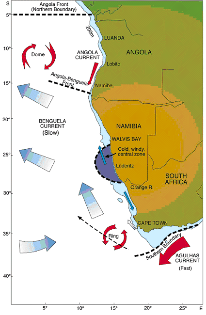
External and internal boundaries of the Benguela Current Large marine Ecosystem, bathymetric features and surface (upper layer)
currents (click the map to see an enlarged
version thereof; there is an "expand to regular size" option).
|
Source: O’Toole, M.J., Shannon, L.V., de Barros Neto,
V., and Malan, D.E. 2001. Integrated Management of the Benguela Current Region.
In: Science and Integrated Coastal Management, ed. B. von Bodungen and R.K.
Turner, pp. 231-253. Dahlem University Press.
|