

| What is LTBP? | |||||||||||||||||||||||||||||||||||||||||||||||||||||||||||||||||||||
| Overview | |||||||||||||||||||||||||||||||||||||||||||||||||||||||||||||||||||||
| Participants | |||||||||||||||||||||||||||||||||||||||||||||||||||||||||||||||||||||
| Regional Offices | |||||||||||||||||||||||||||||||||||||||||||||||||||||||||||||||||||||
| Features: | |||||||||||||||||||||||||||||||||||||||||||||||||||||||||||||||||||||
| Calendar | |||||||||||||||||||||||||||||||||||||||||||||||||||||||||||||||||||||
| Photo Gallery | |||||||||||||||||||||||||||||||||||||||||||||||||||||||||||||||||||||
| Publications | |||||||||||||||||||||||||||||||||||||||||||||||||||||||||||||||||||||
| Programmes: | |||||||||||||||||||||||||||||||||||||||||||||||||||||||||||||||||||||
|
| Biodiversity |
| Databases |
| Mahale Survey |
| Participants |
| Publications |
| Environmental Edu. |
| Fishing Practices |
| Geogr. Info. Syst. |
| Pollution |
| Sedimentation |
| Socio-economics |
| Training |
Processes: |
| Legal Convention |
| Strat. Action Prog. |
Management: |
| Reg. Co-ordination |
Projects: |
| Nyanza Course |
| Uvira Renovations |
| World Environ. Day |
Administration: | Project Resources | | ||||||||||||||||||||||||||||
 The surveys were divided into four components: habitat profile, mollusc census, and two different methods of fish censuses. The surveys were divided into four components: habitat profile, mollusc census, and two different methods of fish censuses.
The first pair of divers conducted the habitat profile, descending to 25 m depth and recording the characteristics of the substratum (e.g. percentage of rocks and sand and their characteristics) and fauna at 10 m intervals along an 80 m transect. 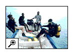
The second pair of divers conducted the mollusc survey, following the transect line set by the previous team. The divers worked at 25 m, 15 m, 5 m and snorkelled at 0-2 m. At each depth, divers tried to note all the gastropod and bivalve species present. Representatives of each species were brought to the surface for definitive identifications. Three different methods were used to survey fish, the Stationery Visual Census (SVC), Rapid Visual Census 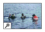 (RVC) and Gill-netting. In the SVC, a pair of divers descended to 15 m and remained there for 15 minutes recording all the fish species they encountered. The divers then repeated the same technique at 10 m and 5 m depths. In the RVC, a pair of divers descended to 15 m depth and swam parallel to the shore for 15 minutes, recording each species of fish they encountered at 3 minute intervals (species were recorded only once). The technique was repeated at 10 m, 5 m and 0-2 m depths, the latter using snorkle technique. Finally, gill nets were set every day at the end of the diving activities and recollected the following morning. At this point, species were identified and the number of each species present was recorded. (RVC) and Gill-netting. In the SVC, a pair of divers descended to 15 m and remained there for 15 minutes recording all the fish species they encountered. The divers then repeated the same technique at 10 m and 5 m depths. In the RVC, a pair of divers descended to 15 m depth and swam parallel to the shore for 15 minutes, recording each species of fish they encountered at 3 minute intervals (species were recorded only once). The technique was repeated at 10 m, 5 m and 0-2 m depths, the latter using snorkle technique. Finally, gill nets were set every day at the end of the diving activities and recollected the following morning. At this point, species were identified and the number of each species present was recorded.
Mr. Bakari Mnaya is Park Ecologist for Gombe Stream and Mahale Mountains National Parks and a member of the BIOSS team in Tanzania. |
|| Home ||
| Previous : |
