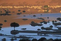
 The Hardap Region is situated in the south central part of Namibia. The Atlantic Ocean and Namib Desert in the West and the Kalahari semi-desert in the East are its breathtaking borders. Hardap is characterised by a variety of spectacular landscapes, which include the greater part of the Namib Dune Sea, Naukluft Mountains and Namib Naukluft Park, the Fish River and large parts of the Kalahari Desert. Truly indigenous cultures in the Nama, the Rehoboth Basters and the wide variety of plant species as well as changing landscapes as you move through the region all amplify the paradoxical yet magical attractiveness of this region. The Hardap Region is situated in the south central part of Namibia. The Atlantic Ocean and Namib Desert in the West and the Kalahari semi-desert in the East are its breathtaking borders. Hardap is characterised by a variety of spectacular landscapes, which include the greater part of the Namib Dune Sea, Naukluft Mountains and Namib Naukluft Park, the Fish River and large parts of the Kalahari Desert. Truly indigenous cultures in the Nama, the Rehoboth Basters and the wide variety of plant species as well as changing landscapes as you move through the region all amplify the paradoxical yet magical attractiveness of this region.
The name assigned to the Region reflects the prominent role of the Hardap dam in the agro-economic development and tourism of this Region.The region is dominated by commercial farmland, which makes up 75% of the total area of the region.The remainder is taken up by the Namib Naukluft National Park (15%) and communal farmland (10%). The Holloms Bird Island, which lies within Namibian territorial waters off the coastline of Diamond Area Sperrgebiet 2, is part of the Region.
The entire coastline falls under the Namib Naukluft National Park and there is minimal road access to the coastline. Entry points exist from both the Karas and Erongo Regions through concessions issued in these regions.
The region has been divided into six constituencies, namely: Gibeon; Rehoboth Rural; Rehoboth West Urban; Rehoboth East Urban, Mariental Rural: and Mariental Urban. Mariental is the seat of the Hardap Regional Council.
Planning Frameworks
After Namibia's independence in 1990, the National Planning Commission (NPC) accepted the central co-ordinating role of the sectoral ministries. Many Line Ministries had by then evolved their own ways of national and regional planning and even today regional planning is still undertaken largely on a sectoral basis with limited co-ordination between Line Ministries, donor-led projects and Non Governmental Organization (NGO) involvement.
The main function of the Hardap Regional Council is to co-ordinate and spearhead regional development. At the moment the direct planning tasks of the Regional Council are confined to the rural areas including informal as well as formal settlements, while planning within the municipal boundaries is the direct responsibility of the Local Authorities. The guidance for this development comes from the Regional Development Plan (RDP). However one of the constraints to development is the fact that the regional council does not generate its own funds and does not have the funds to implement the capital projects identified in the RDP. In light of this the Namibian Cabinet took a decision in 1998 to allocate 20% of the Development Budget to projects identified by Regional Councils. For more information on the regional Development Plan visit the DLIST Library where a copy will be hosted.
The Mariental Municipality has an independent municipality and has its own structure plan. The Municipality is self-supporting and responsible for identifying and financing its own development projects. External funding in the form of grants can be requested through the Association for Local Authorities in Namibia (ALAN) from the Ministry of Finance. Most towns and villages are dependent on grants and administration assistance from the Ministry of Regional and Local Government and Housing, which in turn is responsible for the technical and financial assistance of settlement areas.
Land Reform
 Prior to the German and South African colonization periods, the Nama communities inhabited the Gochas and the Hoachanas areas. The Oorlam groups inhabited the Mariental/Maltahohe and the Leonardville area, and the Baster communities inhabited the Rehoboth area. During the colonial periods the indigenous populations were deprived of large tracts of land. In 1962 a commission recommended that the homeland (communal system) be created. This idea was implemented resulting in the formation of the Namaland Communal Area and the remaining areas reserved for private farmland. Prior to the German and South African colonization periods, the Nama communities inhabited the Gochas and the Hoachanas areas. The Oorlam groups inhabited the Mariental/Maltahohe and the Leonardville area, and the Baster communities inhabited the Rehoboth area. During the colonial periods the indigenous populations were deprived of large tracts of land. In 1962 a commission recommended that the homeland (communal system) be created. This idea was implemented resulting in the formation of the Namaland Communal Area and the remaining areas reserved for private farmland.
After Namibia's independence in 1990 the Hardap region was divided into six constituencies. In 1996 the new government adopted Namibia's decentralisation policy, which is aimed at the devolution of power to lower tiers of Government within the context of a unitary state. The Ministry of Lands administers a Land Reform Policy (Link to Land Reform policy page). The introduction of the resettlement programme in the Hardap Region to accommodate the landless and marginalized groups has been relatively successful. Sixteen farms or 89 987 ha of land were purchased for resettlement purposes between 1990 and 2000 by the Ministry of Lands which amounts to 21.89% of the total farmland purchased nationally.
Mining
The known mineral resources in the Region are of low grade and cannot be mined economically. Close to Mariental there is a clay deposit, which could be mined for pottery production. The diamond resources at Conception Bay and Fishers Pan have been exhausted.
Fishing and mari/agriculture
There are no ports or official access to the coastline and therefore fishing companies from outside of the Region exploit all marine resources that occur off the Hardap Region's coastline. The economy of the region is essentially driven by an agricultural sector dependent on livestock, crop production, ostriches and game.
Conservation and Tourism
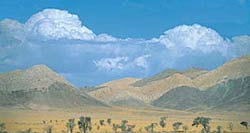
The Hardap Region has great potential for tourism due to the spectacular Namib Desert that has dunes near Sossusvlei regarded as being the highest in the world. Sossusvlei and Sesriem canyon are very popular tourist destinations and there are a number of private operators who operate within the region. However communitybased operations are still very limited within this region. Efforts towards equitable utilization of tourism opportunities are being made with the establishment of a tourism body called Hardap Tourism that will function to promote and coordinate tourism especially community- based tourism.
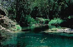 The Naukluft region is located in the pro-Namib and deep pools, high rock walls and large trees dominate this mountainous region. One of southern Africa's toughest self-guided walking trails meanders through this area, taking hikers eight days to complete. There is a wide variety of fauna and flora found within this region. The Naukluft region is located in the pro-Namib and deep pools, high rock walls and large trees dominate this mountainous region. One of southern Africa's toughest self-guided walking trails meanders through this area, taking hikers eight days to complete. There is a wide variety of fauna and flora found within this region.
For more details on these regions view a generic Namibian tourism website such as http://www.namibian.org/travel/namibia/naukluft.htm.
For more information on the Hardap Region contact the Regional Economic Development Planner, Hardap Regional Council, Mr Dugald O C Hammerslacht (hardaprc@iafrica.com.na)
|