 The Karas region is the southernmost and the driest. It is flanked by the Atlantic Ocean in the west, South Africa and Botswana in the east and to the south the border is determined by the Orange River. To the north the regional boundary is with the Hardap region. The Karas region is the southernmost and the driest. It is flanked by the Atlantic Ocean in the west, South Africa and Botswana in the east and to the south the border is determined by the Orange River. To the north the regional boundary is with the Hardap region.
The former Diamond Area 1, usually referred to as the Sperrgebiet, dominates the coastal area. This land extends from the border with South Africa from the high water mark to about 100kms inland and north until the main road running from Aus to Lüderitz. It then shifts 60km towards the sea and continues northwards at a width of approximately 40-60km to the 26 line of longitude (roughly 90km north of Lüderitz). The Sperrgebiet excludes the town lands of Lüderitz and the National Diamond Coast Recreational Area. The northern section of the coastal area of Karas is under the control of the Namib Naukluft Park.
The Region comprises six constituencies: Keetmanshoop Urban, Berseba, Lüderitz, Oranjemund, Karasburg, Keetmanshoop Rural.
Planning Frameworks
Development, mainly in the form of capital projects within rural areas, is determined by the Karas Regional Development Plan (RDP) and is administered by the Regional Council. There are two large settlements along the coast. Oranjemund is a private mining town and has settlement area status and is the constituency capital and managed by NAMDEB. Lüderitz is classified as a town and is the constituency capital. Both settlements will be guided by a structure plan. Lüderitz has recently completed a waterfront development (http://www.economist.com.na/2001/060401/story12.htm) which should bode well for future developments. The Luderitz waterfront was specifically initiated to promote and boost the tourism industry of the beautiful coastal town of Luderitz however, it is still facing a critical housing shortage. The most important planning document for the majority of the Karas coastline is the proposed Sperrgebiet Land Use Plan.
Land Reform
 The region is mostly settled by Nama speaking people. The distribution of land, however, is skewed and unequal. Communal farmers in the Namaland, for example, have to leave their farms to seek employment elsewhere. The region has programmes that run within the national and regional land tenure reform, land management and resettlement policy and strategy. Both Lüderitz and Oranjemund have large populations of people from the north of Namibia who migrated there in search of work. Lüderitz has a large and growing informal settlement as illustrated by the picture below and in an article that appeared in the Namibian in late 1999 (http://www.namibian.com.na/Netstories/December99/pinch.html). The region is mostly settled by Nama speaking people. The distribution of land, however, is skewed and unequal. Communal farmers in the Namaland, for example, have to leave their farms to seek employment elsewhere. The region has programmes that run within the national and regional land tenure reform, land management and resettlement policy and strategy. Both Lüderitz and Oranjemund have large populations of people from the north of Namibia who migrated there in search of work. Lüderitz has a large and growing informal settlement as illustrated by the picture below and in an article that appeared in the Namibian in late 1999 (http://www.namibian.com.na/Netstories/December99/pinch.html).
Mining
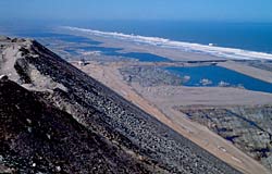 Diamond mining played a major role in the region since the first diamond was discovered in 1911 ushering a colourful part of history. With the downscaling of land-based diamond mining in the Sperrgebiet area opportunities are opening up for activities other than mining and there are plans under way to declare the entire Sperrgebiet as a protected area under the Wildlife and Parks Act. However mining is still a significant contributor to the regional economy and NAMDEB's marine-based operations will continue from Oranjemund. The development of the Kudu gas fields located off the coastline will provide a welcomed alternative to the economy of Oranjemund. The Skorpion Zinc mine near Rosh Pinah is a fast expanding development that is bringing a number of short-term benefits to the region. Diamond mining played a major role in the region since the first diamond was discovered in 1911 ushering a colourful part of history. With the downscaling of land-based diamond mining in the Sperrgebiet area opportunities are opening up for activities other than mining and there are plans under way to declare the entire Sperrgebiet as a protected area under the Wildlife and Parks Act. However mining is still a significant contributor to the regional economy and NAMDEB's marine-based operations will continue from Oranjemund. The development of the Kudu gas fields located off the coastline will provide a welcomed alternative to the economy of Oranjemund. The Skorpion Zinc mine near Rosh Pinah is a fast expanding development that is bringing a number of short-term benefits to the region.
Fishing and mari/agriculture
Fishing companies operating out of Lüderitz harvest the fish stocks along this section of the coast to the maximum. These quotas are set out in the Ministry of Fishing and Marine Resources (MFMR) policy statement issued in 1993 (http://www.mfmr.gov.na ). Lüderitz Bay is one of the best mariculture sites in Namibia and the current oyster and seaweed farms are very successful. There is room for further development of this industry both within the bay and within former diamond mining excavations along the coastline as is practised within the Alexkor Ltd area in South Africa.
Due to the highly arid climate of the area economically viable agricultural opportunities are limited to the northern banks of the Orange River. The Aussenkehr irrigation scheme at Noordoewer which is located a significant distance inland produces fruit and vegetables, mainly table grapes for local and export purposes. These developments if well managed could contribute greatly to the regional economy. However, it is important that their biological impact on the Orange River system and social impact on the local settlements is assessed prior to further development.
Conservation and Tourism
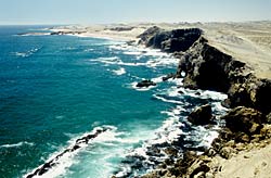
 The Karas region has a high potential for tourism through conservation related activities. The Sperrgebiet, a vast area, has great potential for conservation and tourism. The unique history and spectacular scenery or the area, associated to the potential linkages to the north and south provide numerous opportunities for the future. However the current land use plan proposed still has to get full endorsement at the political level. The Karas region has a high potential for tourism through conservation related activities. The Sperrgebiet, a vast area, has great potential for conservation and tourism. The unique history and spectacular scenery or the area, associated to the potential linkages to the north and south provide numerous opportunities for the future. However the current land use plan proposed still has to get full endorsement at the political level.
Lüderitz is at the centre of coastal tourism and the opportunities abound beyond the Sperrgebiet area in the form of visits to a number of coastal islands for bird enthusiasts. The town itself has charming architecture and a fascinating history in terms of diamond mining and the wars waged by Germans against the local people.
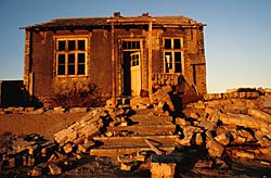
The Hot Water Springs at Ai-Ais (in future probably also the Hot Water Springs in Warmbad), the Kokerboom forest near Keetmanshoop, the Fish River Canyon (the second largest in the world), the Brukaros Mountain (a former volcano) near Berseba, the coastal town Lüderitz and Kolmanskop, a nearby ghost town have become popular sites for shooting film footage and tourism. For more information on each of these tourism destinations visit a generic tourism website such as http://www.southafrica-travel.net/namibia/enamib.htm.
For more information contact the Karas Regional Council Economic Planner: Ralph Sachika, Planner, Karas Regional Council, Private Bag 2184, Karas Regional Council, 40 Wheeler Street, Keetmashoop (rsachika@karasrc.com, suchcar@mweb.com.na) Tel: +264 63221900. You can also look at the document in the library titled Towards Integrated Development Planning in the Karas Region.
|