| |
The geographical scope of the Convention on the Protection of the Black Sea against
Pollution is applied to the Black Sea proper, with the Southern boundary constituted, for the
purposes of this Convention, by a line running between Capes Kelagra and Dalyan  |
| |
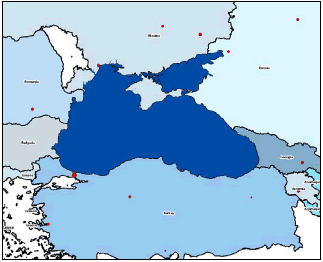
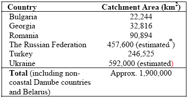
The Black Sea is an inland Eurasian sea bordering Ukraine and the Russian Federation to the north, Bulgaria and Romania to the west, Georgia to the east and Turkey to the south (Fig. 3.1). The Sea is located between latitudes 40° 56’N and 46° 33’N, and longitudes 27° 27’E to 41° 42’E. It is located in the east-west depression between two alpine fold belts, the Pontic Mountains to the south and the Caucasus Mountains to the northeast. The topography of the north western coast (except for Crimea) is relatively low and flat. The area of coastal country sub-basins is shown in Table 3.1
|
Figure 3.1 Geographical and hydrological boundaries in Black Sea Region |
The Black Sea is a semi-enclosed, connected to the shallow (10–20 m) Azov Sea through the Kerch Straits and to the Mediterranean Sea through the Bosporus Straits, the Marmara Sea and the Canakkale Strait. The flat abyssal plain (20% of free surface, depth. 2000 m) rises to the continental shelves. The northwestern shelf (mean depth 50 m) has a shelfbreak at about 100 m between the Crimean peninsula and Varna in the South. The Danube and the Kerch fans are gentle continental slopes. The other portions of the shelf are narrow (20 km), fractured by canyons, abrupt ridge extensions and steep continental slopes.
|
|
* On the assumption that 15% of the Severskiy Donnets river basin (98, 900 km2) lies in Russia and 85% lies in Ukraine. The direct Russian Black Sea Catchment (i.e. excluding land draining into the Sea Azov) is 8,100 km2 |
The only connection to other marine water bodies is through the winding Istanbul (Bosphorus) Straits, a 35 km natural channel, as little as 40 m deep in places. The Black Sea is up to 2,212 metres deep (North of İnebolu) and receives the drainage from a 1.9 million km2 basin, covering about one third of the area of continental Europe. The Istanbul Strait has a two layer flow, carrying about 300 km3 of seawater to the Black Sea from the Mediterranean along the bottom layer and returning a mixture of seawater and freshwater with twice this volume. |
| |
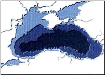
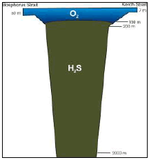
The seabed is divided into the shelf, the continental slope and the deep-sea depression (Fig. 3.2). The shelf occupies a large area in the north-western part of the Black Sea, where it is over 200 km wide and has a depth ranging from 0 to 160 m. In other parts of the sea it has a depth of less than 100 m and a width of 2.2 to 15 km. Near the Caucasian and Anatolian coasts the shelf is only a narrow intermittent strip. The thin upper layer of marine water (up to 150 m) supports the unique Black Sea ecosystem. The deeper and more dense water layers are saturated with hydrogen sulfide that has accumulated over thousands years as a by-product of decaying organic matter (Fig. 3.3). Due to the unique geomorphological structure and specific hydrochemical conditions, very specific organisms, including protozoa, bacteria, and some multi-cellular invertebrates, inhabit the deep-sea waters. Knowledge about forms of life in the deep waters of the Black Sea is very limited, but it is clear that disturbance of the natural balance between the two layers could trigger irreversible damage to the people and ecosystem of the Black Sea.
|
Figure 3.2 Black Sea bathymetry |
|
|
Figure 3.3 Profile of the hydrogen sulfide zone in the Black Sea |
| |
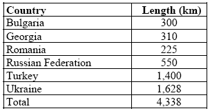
The length of the Black Sea shoreline is approximately 4,340 km (Table 3.1). The Black Sea has similar geological properties as the major oceans, and is classified geomorphologically into three key sections namely: (i) the continental shelf, (ii) the continental side, and (iii) the abrasion platform (2).The continental shelf covers 24.1% of the Black Sea surface area and has a 0.5-5‰ slope. This area generally extends 0-90 m depth from the shoreline. The continental shelf is very important for fishing, although it is quite narrow along the Anatolian and Caucasus coasts.
The length of national Black Sea costlines is presented in Table 3.2, Ukraine having the longest coast and Romania the shortest.
|
| |
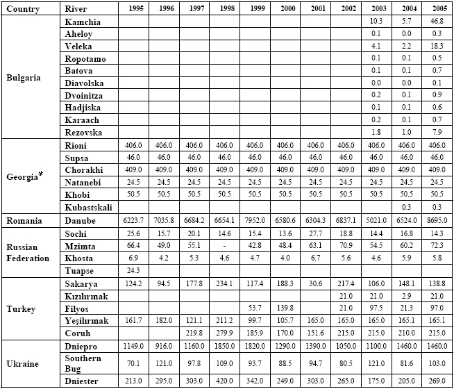
The main rivers in the Black Sea Region are the Danube, Dnipro, Rioni, Kodori, Inguri Chorokh, Kizilirmak,Yeshilirmak, Sakarya, Southern Bug and Dnister. Every year, some 350 km3 of river water flows into the Black Sea. Discharges from the main rivers are presented in Table 3.3, with inflows of water from the Sea of Marmara (via the Istanbul Strait) and the Sea of Azov (via the Kerch Strait) shown in Table 3.4. The areas of national Black Sea sub-basins are shown in Table 3.1. |
|
In a major part of the Black Sea Basin, the climate is similar to the Mediterranean (warm humid winters and hot dry summers) because the geography and macro circulation processes existing in the Mediterranean influence the climate of the Black Sea Basin. The south-eastern part, surrounded by the mountains, is characterized by a humid subtropical climate (abundant precipitation, warm winter, hot summer). Average periods of sunshine vary throughout the region – 2,432 hours in the Istanbul area, 2,237 hours in the Varna area and 2,223 hours per year in the Yalta area. The total amount of precipitation from Istanbul to Varna is about 500-700 mm per year, in the north, near Odessa – 300-400 mm, in the southern coast of Crimea (Yalta) – 586 mm. The amount of annual precipitation increases eastward – 1,600 mm between Novorossiysk and Sukhumi, to 2,465 mm – in Batumi. In general, the Black Sea Basin climate is very favorable for tourism and recreation.
Because of its climate the Black Sea region is a productive farming area, where many varieties of plant crops are grown. Thus, for those countries having only a part of their territory included in the Basin, these national sub-basins represent important components of their respective national agricultural production balance sheets For example, in Bulgaria, land draining into the Black Sea contains.about 85% of the national cereal farmland, 76% of the land on which oil bearing crops are grown, 37% of the land used for forage crops and 47% of the area of national vineyards (Petkova, 2005). The agricultural area in the Turkish Black Sea sub-basin contains approximately one third of the total agriculture area of Turkey, supporting the production of a wide range of agricultural crops. For example, all of the tea grown in Turkey is produced in this area, 71% of national nut production, 57% of tuber crops, 39% of industrial crops, 33% of cereals, 24% of pulses and vegetables, 18% of fruits and 9 5% of oil seed production (Ulger 2005). For further comparison about one third of the agricultural area of Georgia is contained in its Black Sea sub-basin, where all of its national tea and citrus fruit ptoduction occurs, the vast majority (98%) of the country’s volatile oil bearing plant production, about 80% of nuts, over 50% of other fruits, 40% of cereals, and over 30% of national vineyard production (Lagidze, 2005 – data exclude statistics from the breakaway republic of Abkhazia). Similarly, the Black Sea coastal administrative areas of the Russian Federation, particularly Krasnodar Krai, constitute a nationally important agricultural region.
|
| * Discharge based on long-term investigations carried out before 1993 |

In addition to arable farming, the Black Sea Basin is also an important area for livestock farming. This is dealt with in more detail in Section 4.2.4.2.
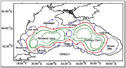
Ocean current circulation in the Black Sea is characterized by a cyclonic system of currents Fig. 3.4). The dynamic system of the Black Sea has a distinct yearly cycle, with maximum circulation activity occuring during winter and spring.
|
Figure 3.4 Schematic of Black Sea currents |
|
|
|
|
|
|