| |
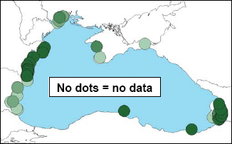
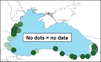
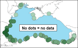
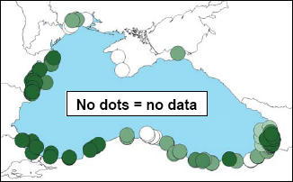
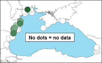
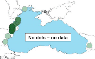
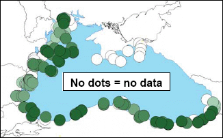
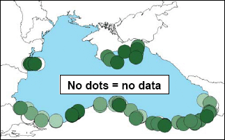
Fig. 3.21 shows average concentrations of four parameters in surface waters (0-10 m) of the Black Sea, with nitrate and phosphate displayed in Fig. 3.23. The data are not de-seasonalised and are presented with reference to a quantile (5-class) system, such that for each parameter approximately 20% of the results fall into each class. For each map, the darker the colour the greater the concentration, with class boundaries as follows:
|
| |
| |
BOD5 |
Dissolved copper |
|
|
| |
|
Total suspended solids |
Total petroleum hydrocarbons |
|
|
Figure 3.21 Mean concentrations of BOD5, dissolved copper, total suspended solids and total petroleum hydrocarbons in surface waters (0-10m depth) of the Black Sea, 2000-2005 |
|
Note to Figs 3.21, 3.22 and 3.23 |
| |
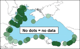
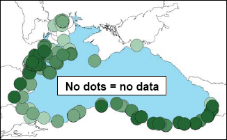
In earlier drafts of this document, Figs 3.21-3.23 proved to be controversial; not because of the data they presented, but rather because of the lack of data provided by some countries. The darker the colour, the higher the concentration. Where no circles (regardless of colour) are present on the maps, no data were provided to plot. This does not imply an absence of chemical pollution at those sites. |
BOD5levels are elevated along the Romanian coasts, where discharges from the Danube and Dniester rivers exert their greatest influence, as well as at several sites along the Georgian coast, due to a combination of untreated municipal and river discharges.
Dissolved copper levels appear to be elevated along much of the Turkish coast, with with more isolated examples off the Romanian and Georgian coasts. It is not clear whether these result arise principally from point sources or are due to geological differences. No data were available for Ukrainian coastal waters. Data were provided for Russian waters only after the above analysis had been completed. These showed that dissolved copper concentrations varied between 0.323 and 65.4 µg/l. The highest concentration, recorded in Sochi Harbor, is 13 times higher than the maximum allowable concentration according to Russian regulations.
Total suspended solids is a measure of the amount of particulate matter (of biological and geological origin) in the water column. This can be related to trophic status, since phytoplankton form a proportion of the material measured. Major river inflows tend to result in turbidity/suspended solids plumes within the Sea, although this is not clear from the scale of data shown. The pattern which emerges is interesting, however, Petroleum hydrocarbon levels (a measure of oil pollution) are highest in three distinct areas: off the Georgian coast (important oil terminals/ports); the west Turkish coast, which ties in with the pattern of water flow shown in Fig 3.4 and the pattern of likely oil spills reported in Fig. 4.16; and at several points along the Romanian coast. The latter could be due to shipping-related oil spills, point source discharges or the influence of high levels of oil in Danube waters – highlighted as a cause of concern in the 1996 TDA, but now probably less important than it once was.
As with dissolved copper, Russian petroleum hydrocarbon data were not provided until after the analysis presented in Fig. 3.21 had been undertaken. Nevertheless, Russian values varied from <LoD to 3.2 mg/l, the highest values occurring close to Socchi. Concentrations of 1-2 mg/l were measured at numerous sites during 2003-2005, albeit that most concentrations were <0.5 mg/l. However, as the Russian maximum allowable concentration is an order of magnitude lower than this, the cited values do not present an optimistic picture of Russian coastal waters.
Fig. 3.2.2 shows average concentrations of six parameters in surface sediments (up to 20 cm depth) of the Black Sea. Data are presented with reference to a quantile (5-class) system, such that for each parameter approximately 20% of the results fall into each class . For each map, the darker the colour the greater the concentration, with class boundaries as follows: . For each map, the darker the colour the greater the concentration, with class boundaries as follows:
|
Copper |
|
|
| |
|
DDT |
Total HCHs |
|
|
| |
|
Total organic carbon |
Total petroleum hydrocarbons |
|
|
| |
|
Figure 3.22 Mean concentrations of chromium, copper, DDT, total HCHs , total organic carbon and total petroleum hydrocarbons in sediments of the Black Sea, 1996-2006 (See note below Fig. 3.21.) |
As with Fig 3.21, higher concentration values are plotted on top of lower values to emphasise where attention needs to be paid in terms of reducing discharges (river, municipal or industrial) to water.
Chromium concentrations are particularly elevated along the western-central area of the NW Shelf, where the influence of the Danube and Dneister are greatest. There is also a suggestion that discharges from land in the Odessa and Samsun areas may also be potential sources.
Copper contamination in sediments mirrors that of copper levels in surface waters (Fig. 3.21), with elevated concentrations along the eastern Turkish and southern Georgian coast (possibly due to copper of geological origin, but copper mine tailings treatment at Murgul, Turkey, close to the Georgian border, has not been upgraded, despite the mine having been identified as a hot-spot in need of capital investment in the 1996 TDA (see Section 5 and Annex 11). Copper levels are also elevated along the western edge of the Black Sea, where the Danube and Dneister rivers enter the Sea. Elevated levels are also present in sediments off the Bulgarian coast, but it is not clear whether these are due to river-borne or direct municipal/industrial discharges.
DDT’s distribution is very patchy in sediments, being alarmingly high at one Ukrainian coastal site, with less severe but more widespread contamination off the Romanian coast. The levels of Romanian sediment DDT contamination are mirrored in the Total HCH results. Russian data (not shown in Fig 3.2.2), showed relatively high levels of the total DDT group (>4 ng/g) to be present in coastal sediments near Gelendzhik, Arkhipo-Osipovka, Lazarevskaya, Sochi and Adler.
Total organic carbon, as a measure of organic enrichment, does not follow the exact pattern that might be expected from previous analyses of zoobenthic communities (e.g. Todorova and Konsulova, 2006) and dissolved oxygen assessments. However, there is considerable contamination in the mid-NW Shelf, some way removed from land, suggesting that phytoplankton blooms are the major source of this enrichment. And, as the status of zoobenthos communities improves in a general pattern from north to south in the the NW Shelf, so does the overall level of organic enrichment reduce. Organic enrichment at several sites along the Turkish coast is also elevated. Here, phytoplankton blooms are not as intense as those found in the NW Shelf, so it appears that land-derived organic sources could be more important.
Unlike copper, sediment contamination with total petroleum hydrocarbons does not reflect the level of contamination in surface waters (cf Figs 2.21 and 2.22). In sediments, levels of contamination on either side of the Istanbul Srait are comparatively lower than those found in surface waters. Oil contamination in sediments along the east Crimean coast.and perpendicular to where the Kerch Strait enters the Sea is also particularly high. Presumably, the elevated Ukrainian results reflect the high level of ship traffic through the Kerch Strait. Elevated levels of sediment oil contamination at two sites off the Romanian coast do, however, mirror the high concentrations found in surface waters.
Relatively high contamination levels of some pesticides, heavy metals and PCBs have been found at sites in the Black Sea (e.g..Parr et al, 2005). The concentrations of some substances are in or above the ranges used as Ecotoxicological Assessment Criteria (EACs) by OSPAR. Whilst the applicability to the Black Sea of EACs developed for the NE Atlantic is not known, the significance of the detected contamination should be further investigated. |