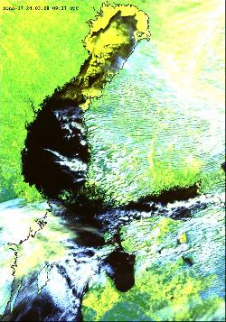
The ice season 2007-2008
|
||||
Key Message
The ice season 2007-2008 was very late, short and extremely mild in terms of ice extent.
According the Russian Ice Service the ice season was the warmest during more than the 100-years period of observations. Particularly, for the first time in history the fast ice was not generated on fairway of the Neva Bay and the ice edge was not extended westward of the Sescar Island longitude.
The largest ice cover – 49,000 km² – was reached as late as on the 24th of March.
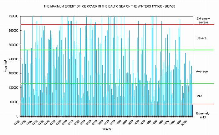
The ice winter was, by the extent of the ice cover, classified as extremely mild (Figure 1.)
The ice winter was in the Gulf of Bothnia 5-7 weeks shorter than normal. In the Archipelago Sea and the Gulf of Finland no ice winter can be considered having existed with the exception of the Russian sea areas.
On the 25th May the Baltic Sea was ice free.
Figure 1. The maximum extents of ice cover in the Baltic Sea on the winters 1719/20 – 2007/08 (Courtesy of FIMR).
Ice formation
Gulf of Bothnia
The October was warmer than usual with the temperature of the seawater at the end of the month being above the average by one to two and a half degrees Celsius.
In the northern Bay of Bothnia the freezing begun in mid November, two weeks later than normal. Then the first thin ice in the archipelagos between Luleå and Haparanda was observed on 18th of November. The ice formation in northern Bay of Bothnia proceeded and in the beginning of December thin ice covered also the outer archipelagos.
In December, mild and cold periods alternated. December was exceptionally warm with no notable increase in the amount of ice. At the end of the year the northern Bay of Bothnia and places in the inner archipelago were covered with ice.
In early January the weather got colder with ice forming in coastal regions of the Bay of Bothnia, the Vaasa archipelago and the inner archipelago of the Sea of Bothnia. In the open Bay of Bothnia south-westerly winds formed a brash barrier at the ice edge. Following a cold spell of about a week the temperature in Finland remained five to ten degrees Celsius above the average until the end of the month with no new ice formation. At the end of January the inner archipelago of the Bay of Bothnia, the Vaasa archipelago and the inner archipelago of the northern Sea of Bothnia had an ice cover. In the open seas of the Bay of Bothnia the ice edge ran approximately along the line of Raahe lighthouse–Malören–Nygrån.
In mid-February there was a cold spell with the amount of ice increasing. The Bay of Bothnia north of the line Marjaniemi–Falkensgrund–Piteå and the coastal regions had ice cover. The Vaasa Archipelago and the inner archipelago of Sea of Bothnia were frozen. In places the Archipelago Sea was covered with thin ice between the islands.
February ended mild and at the turn of the month only the ice cover in the Bay of Bothnia had increased a little with the open sea areas frozen to the north of the line Raahe–Skellefteå.
In the beginning of March a colder period followed, causing new ice formation in the entire Quark as well as in coastal areas of southern Bay of Bothnia and along the Finnish coast of Sea of Bothnia. The drift ice in the northernmost parts was at this time 10-35 cm thick. The ice growth however ceased as fresh southerly winds entered Swedish waters. The new ice at sea rapidly broke up and disappeared.
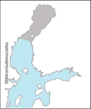
During Easter weekend 20-24 March, a portion of Arctic air overspread all Scandinavian waters. On the Swedish side, a band of heavy ice floes slowly drifted southwards from Bjuröklubb to Holmöarna. The ice cover reached the winter's maximum on 24th of March with 49,000 km2, the all-time low. At that time, remaining parts of Bay of Bothnia, the Quark and also the sea area past Sydostbrotten shortly was covered by thin ice or new ice. At same time, some 50 cm thick drift ice floes were observed in the northern Bay of Bothnia.
Gulf of Finland
The ice conditions in the Gulf of Finland during the winter season, 2007-08 characterized by the extremely warm winter. This ice season was the warmest during more than the 100-years period of observations of the Russian ice service. Particularly, for the first time in history the fast ice was not generated on fairway of the Neva Bay and the ice edge was not extended westward of the Sescar Island longitude.In the Gulf of Finland, off St. Petersburg, the freezing begun in mid November, approximately two weeks later than normal. In the coastal zone of the Neva Bay the ice formation commenced on the 14th of November, when the shuga was drifting from the Lake Ladoga. Then the ice formation was accompanied by drifting shuga. The first appearance of ice in the inner Vyborg Bay was fixed on the 20th of November.
During December the character of ice formation remained invariable. From the 4th of December the ice formation stopped and slow melting began. During the second and third decades of the month the compact partly rafted ice, 5-15 cm thick, concentrated in the eastern part of the Neva Bay. The Vyborg Bay covered with the compact nilas ice 3-7 cm thick.
In early January the weather got colder with ice formation in coastal regions. The fast ice appeared in the Neva Bay along the coast and also along the northern coast in the Sestroretsk’s offshore. On all area of the Neva Bay the compact ice was observed. The nilas edge reached the longitude of Shepelevski lighthouse by the end of the first decade. The amount of ice increased with thin ice forming in the archipelago of the Kotka-Hamina area. Since the 9th of January the ice formation stopped and the slow destruction of ice started.
Since the 15th of February the slow ice formation began on the area of the gulf, but during only one week. The ice thickness of the compact ice in the Neva Bay increased up to 15-25 cm. The inner archipelago of the Gulf of Finland had thin ice cover. Off St. Petersburg and Vyborg the new ice came up to island Seskar.
During the first decade of the March the ice formation slow continued. The maximum development of the ice conditions in the Gulf of Finland fixed by the 7th of March. The ice edge at that time ran by the line cape Kolgompya – Bolshoy Berezovyj Island. The fast ice 20-30 cm thick observed only in the area of Lisij Nos and the Sestroretsk’s offshore along the coast. In the Neva Bay the compact partly hummocked ice 15-25 cm thick was observed and there was the short-time formation of some polynyas.
The largest ice cover
During Easter weekend 20-24th March, a portion of Arctic air overspread all Scandinavian waters. On the Swedish side, a band of heavy ice floes slowly drifted southwards from Bjuröklubb to Holmöarna. At the same time, remaining parts of Bay of Bothnia, the Quark and also the sea area past Sydostbrotten shortly was covered by thin ice or new ice. The Finnish coastal regions of Sea of Bothnia and Gulf of Finland had a very thin ice cover in places in the inner archipelago. The eastern Gulf of Finland had a thin ice cover in the Bay of Vyborg and off St. Petersburg. The ice cover reached the winter's maximum on 24th of March with 49,000 km2, the all-time low (Fig 2. and Fig. 3.).
|
|
Ice breaking up
During the March in Luga and Kopora Bays the short-time dark nilas formation was observed from time to time. The full clearance of ice at the both bays finished March 10-11th. During the second decade of March the destruction of ice began at the whole of Gulf of Finland area. During Easter weekend the short-time ice formation occurred. Only a few days after maximum ice extent in the end of March, the ice limit was forced northwards in the Bay of Bothnia. In connection with strong southerly winds wide leads with open water formed, both Swedish and Finnish side.
From 4th of April, almost all drift ice was located north of Bjuröklubb latitude. Windy weather dominated by north-easterly near gale then caused a few days of heavy ice pressure in Bight of Skellefteå. By the end of the first week of April the ice had become rotten in the Gulf of Finland and the Bay of Bothnia up to the latitude of Kokkola.
The Neva Bay and main fairway were ice-free by the 9th of April as well as the Sea of Bothnia. The fairway to Primorsk was ice-free by the 10th of April. It was about three weeks earlier than normal. In the following days small quantity of rotten ice kept only in the inner area of the Vyborg Bay and in along Zelenogorsk shoreline. The full clearance of ice of the Gulf of Finland finished on the 16th of April.
At the same time the open areas of the Bay of Bothnia were free from ice with the exception of the Swedish northern archipelago. The remaining coastal ice in the Bay of Bothnia disappeared in the beginning of May so that the Bay of Bothnia was ice-free on 15th of May.
The ice winter in the northern Bay of Bothnia was almost five weeks shorter than average. In the southern Bay of Bothnia the ice season was almost seven weeks, in the Quark more than five weeks and in the Sea of Bothnia almost six weeks shorter than average. In the Archipelago Sea and the Gulf of Finland no ice winter can be considered having existed with the exception of the Russian sea areas.
Southern sea areas
Gulf of Riga
The first ice formation in coastal areas of Gulf of Riga began in the first decade of January. Fast ice, 5-10cm thick, formed along coast of the Pärnu Bay and the Moonsund Strait by the end of the decade. After that the ice ridged in the Pärnu Bay.
By the end of January there was in eastern part of the Pärnu Bay fast ice, 10-15cm thick and ridged. The rest of the Gulf of Riga there was very open pack ice.
During the February there was fast ice, 15-20 cm thick in the Pärnu Bay. Further on there was a strip of drifting ice. In the Moonsund Strait there was very open young ice. The melting started during February and the rest of rotten ice strips disappeared in the end of February.
The rest of the Gulf of Riga was open water during the whole ice winter.
The Baltic Proper
The beginning of the ice season was very late in the Baltic Proper. The coastal area near Nida the primary ice forms (ice pieces) appeared only on 12-25th February. The shore ice did not form. Only occasionally floating ice was pushed to the coast by appropriate wind.
In the Kurshiu Marios (Curonian lagoon) the primary ice forms appeared on 25th of January. The lagoon was fully covered by ice on 8th of February and the maximum thickness of ice was 25 cm. The shore ice melted on 10th of March.
The southern Baltic Sea
The ice winter of 2007-2008 was mild in the southern Baltic Sea (fig. 4). Although there was more ice than during the last winter, the ice formation occurred only in shallow, sheltered coastal waters, whereas the sea area remained ice free the whole winter. In the southern Baltic Sea only eight winters were been weaker than this one since ice winter 1896-97.
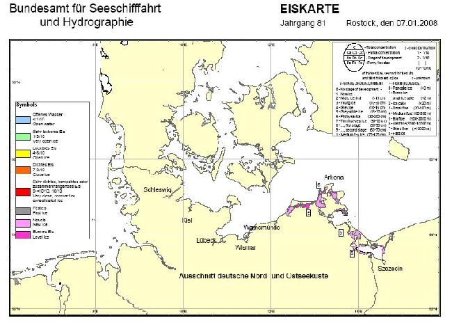
The warm weather continued mostly even in January and February. The first short cold spell in late December led to cooling of the water temperature down nearly to the freezing point in the inner coastal waters. However, first ice has formed predominantly during the second cold spell early January. The ice observers reported start of ice formation in small harbours and in the sheltered Bodden lagoons as well as in the inner fairways of the coast Mecklenburg-Vorpommern on 4th and 5th of January. The ice period lasted one week in the entrances to the harbour of Stralsund and in the western Bodden waters. Nearly three weeks ice was observed on the northern coast of Szczecin Lagoon and in the Dänischen Wiek in the Greifswalder Bodden. Maxima of ice development occurred on 7th January (Figure 5). On 14 January compacted ice was concentrated mostly at the northern coast of Szczecin Lagoon. Level ice reached thicknesses 5-10 cm.
According to the warm winter, obstructions to navigation did not occur in the German outer waters throughout this winter season, and only low-powered vessels were slightly hindered on a few days on the fairways to Stralsund, on the Peenestrom and in the Szczecin Lagoon. Ice occurred on the inner Schlei on 24th of December and in the harbour of Tönning on 5th and 6th of January.
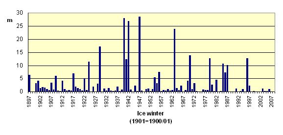
Figure 4. Distribution of accumulated areal ice volume (German Baltic coast) in the period 1897 – 2008 (Courtesy of BSH).
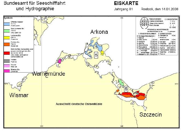
Figure 5. Ice conditions on the German coasts on 7 and 14 January 2007/2008 (Click maps to enlarge).
Ice thicknesses
The maximum fast ice thickness in the Bay of Bothnia was 40-60 cm, Sea of Bothnia 5-30 cm, Archipelago Sea 1-10 cm and in the western and middle Gulf of Finland 1-10 cm and in the eastern Gulf of Finland 15-30 cm.
In the open sea areas of the Bay of Bothnia the ice thickness for the northern parts was 20-50 cm and for the southern parts 5-30 cm. The open areas of the Sea of Bothnia remained ice-free similarly to those in the Gulf of Finland apart from its easternmost part, where the maximum ice thickness of the open sea areas was 10-15 cm.
The maximum thickness of the fast ice in the Pärnu Bay was 15-20 cm.
The maximum thickness of the fast ice at Lithuanian coastal areas was 25 cm by Nida.
In the southern Baltic Sea the level ice reached thicknesses 5-10 cm.
1 Finnish Institute of Marine Research (FIMR), Ice Service, Finland
2 Federal Maritime and Hydrographic Agency (BSH), Ice Service, Germany
3 Swedish Meteorological and Hydrological Institute (SMHI), Ice Service, Sweden
4 Center of Marine Research (CMR), Lithuania
5 St. Petersburg Hydrometeorological Center, Ice Service, Russia
6 Latvian Environment, Geology and Meteorology Agency, Latvia
For reference purposes, please cite this indicator fact sheet as follows:
[Author’s name(s)], [Year]. [Indicator Fact Sheet title]. HELCOM Indicator Fact Sheets 2008. Online. [Date Viewed], http://www.helcom.fi/environment2/ifs/en_GB/cover/
Last modified: 6 October 2008
