|
|
|
|
People wonder why our sea is called "black". On sunny days, the seawater is blue-green and when the sky is heavy clouded, it is silver-grey or azure. Ancient Greeks first called it Pontus Axeinus meaning an “inhospitable sea”. In comparison to the Mediterranean , they found it cold and stormy, and even dangerous because of the wild tribes inhabiting its shores. It took a few centuries for the Ancient Greeks to get to know the Black Sea and its human inhabitants, before they changed their mind and started calling it Pontus Euxinus (“Hospitable Sea”), often referring to it in a friendly way, simply as the Pontus. Its treasures were reflected in the myth of the Golden Fleece, and Herodotus describes it as the most remarkable of all seas. There are several hypotheses for the origin of its present name. Historians say that it is an old name given by the Persians. Hydrologists explain it by the Black sea 's ability to tint metal objects black, due to high content of dissolved hydrogen sulphide. Biologists tend to explain it with the fact that there is no oxygen and virtually no life in its depths. Whatever the origin of it present name, the Black Sea is unlike any other sea in the world, and it is greatly important for all people living around it, for it sustains them and supports their economy by attracting millions of tourists.
|
|
| Physical geography: Facts and figures |
| The Black Sea is a small intercontinental sea situated East-West between Europe and Asia . Six countries border the sea: Bulgaria and Romania to the West, Ukraine to the North, the Russian Federation to the North-East, Georgia to the East and Turkey to the South.
The Black Sea is one of the most landlocked seas in the world. Its isolation from the world ocean is due to the restricted link with other seas. It communicates to the Southwest with the Sea of Marmara through the Bosphorus Strait and with the Aegean Sea and the Mediterranean through the Dardanelles , and further with the Pacific through the Gibraltar . In the Northeast the Black Sea connects with the shallow Sea of Azov through the Kerch Strait .
Table 1. Geographical Coordinates of the Black Sea |
Distances |
W ( Burgas Bay , Bulgaria ) |
27 0 27' |
Max 1149 km |
E (between Batumi and Poti , Georgia ) |
41 0 42' |
Min |
S ( Giresun , Turkey ) |
40 0 56' |
Max 611 km |
N ( Berezan – Ochakov , Ukraine ) |
46 0 33' |
Min 263 km |
Part of the Black Sea uniqueness depends on the fact that its surface area is about five times less than its drainage area, which covers entirely or partly the territory of 20 countries in Central and Eastern Europe and 2 in Asia . These include the six states surrounding it and also Germany , Switzerland , Italy , Austria , Poland , the Czech Republic , Slovakia , Hungary , Slovenia , Albania , Macedonia , Bosnia and Herzegovina , Croatia , Serbia and Montenegro , Belarus and Moldova .
Table 2. The Straits |
Minimum width /km/ |
Maximum depth /m/ |
Bosphorus |
0.7 |
80 |
Dardanelles |
1.3 |
106 |
Gibraltar |
14.0 |
1181 |
Kerch |
3.7 |
11 |
The second and the third biggest rivers of Europe feed the sea with fresh water and influence the salinity of marine waters. The inflow of the Danube , the Dnistro, the Dnipro and the Don play even greater role in the Black Sea water balance than evaporation and the exchange of saline waters with the Mediterranean (which forms only 0.1% of the sea volume annually). The first three rivers together with the South Bug , entering the sea in the northwestern part, contribute more than 70 % of all fresh water flowing into it. The rivers on the eastern, southern and western coasts have much smaller drainage areas and provide about 20 % of fresh water inflow.
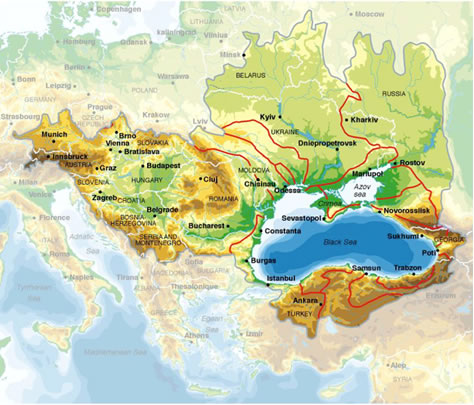 |
Table 3. Geographical Facts about the Black Sea |
Surface area / km 2 / |
423,000
(462,000 with the Sea of Azov ) |
Depth /m/ |
1271 (average)
2212 (maximum) |
Drainage area / km 2 / |
2,500,000 |
Volume /km 3 / |
547,000 |
Tides /cm/ |
3-10 |
Length of coastline / km/ |
4090 |
Number of islands / km 2 / |
About 10 (with area more than 0.5) |
|
The kidney-shaped sea depression is surrounded to the West and North by the relatively low lands in the Balkan Peninsula and Eastern Europe, where the Balkans (mount Botev, 2373 m), the Danube Plain with the Danube Delta, the Russian Plain and the Crimean Mountains (mount Roman Kosh, 1545 m) border the sea. The East and Southern coasts rise in the skirts of the Caucasus (mount Elbrus, 5642 m) and the Pontic Mountains ( mount Kachkar , 3937 m) in Asia Minor . It is only the Kolkhida lowland that breaks the mountainous relief to the East.
Table 4. The Black Sea Rivers |
Main rivers |
Length /km/ |
Drainage area /km 2 / |
Danube |
2,860 |
817,000 |
Dniepr |
2,201 |
504,000 |
South Bug |
806 |
63,700 |
Dniestr |
1,362 |
72,100 |
Don / Azov Sea / |
1870 |
422,000 |
Kuban / Azov Sea / |
870 |
57,900 |
Rioni |
327 |
13,400 |
Chorokhi |
438 |
22,000 |
Kizilirmak |
1151 |
77,100 |
Sakarya |
790 |
65,000 |
Kamchia |
244.5 |
5,358 |
The coastline is generally mildly curved. The only large peninsula is to the North - the Crimea with the Tarkhankut and the Kerch Peninsula linked to it. The few large bays lay in the northern and northeastern parts - the Odessa Gulf , Yagorlikskiy, Tendrovskiy, Karkinitskiy, Kalamitskiy Bays and the Novorossiysk Bay in the East. The biggest of only few islands (Zmeiniy, Tendrovskiy, Berezan) are also in the northwestern part. The coast is low and flat, and sandy spits often bar the river mouths. Brackish and salty lagoons form large wetlands with great ecological importance. The eastern coastline of Georgia has weak indentation with no sheltered closed bays. Only few smaller peninsulas and bays are located in the South in Turkey – the Capes Ince, Chum, Baba and the Sinop and Samsun Bays . The western coastline is also slightly ragged by the Burgas and the Varna Bays and the small peninsulas of Nessebur and Cape Kaliakra .
|
|
|
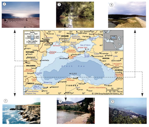
1.The Steppe Landscape in Dobrudgea |
4.Flooded River Mouths and Spits |
| 2.The Sandy Beaches Landscape in the West |
5.The West Coast Landscape |
| 3.The Danube Delta Wetlands |
6.The South Coast landscape |
|
Fig. 2 Black Sea Landscapes |
The coastal landscapes represent a remarkable diversity that illustrates the transition of three basic types of environments (biomes):
The steppe landscapes stretch along the Northwest and the Northern coast of the Black and the Azov Seas . These plain or hilly regions have a dry temperate climate. The typical grass vegetation paints the plains with the bright colours of the blooming plants in humid spring, while in summer, the steppe turns dark yellow with the grass drying up under the hot sun. Winters are cold and windy and the snow covers the plains in white for several months. On the Western coast, the steppe gradually turns into the so-called Balkan landscapes, which have milder temperate climate providing for the predominantly oak-forest vegetation. The exclusively fertile soils (“chernozem”) and the flat relief led to the development of intensive arable agriculture. In some cases however, intense agriculture and excess use of chemicals led to the depletion of the quality of soils and pollution of watercourses. Low intensity organic farming is often proving to be a more sustainable practice. The wide and flooded river mouths on the Western and Northwestern coasts form valuable wetlands rich in unique wildlife. The Danube Delta ( see illustration 3 ) as well as the Bulgarian and Ukrainian coastal wetlands ( see illustration 4 ) have great ornithological importance because they are located along the rout of Via Pontica and host a variety of migratory birds. Perfect large fine-sand beaches alternate with picturesque steep and rocky plateau slopes on the shores of Bulgaria and Romania and provide attractions for tourists ( see illustrations 1 and 2 ).
The humid subtropical landscapes are typical for the Kolkhida plain on the Eastern Black Sea coast where winters are relatively warm and extremely humid. The annual precipitation here varies from over 2000 mm to almost 4000 mm on the mountain slopes. The high Caucasus to the North protect the shore from continental influence ( see illustration 5 ) while the West–East transfer of humid air masses from the Black Sea accounts for the extreme rainfall. Such climate favours the rich tropical-like vegetation of the so-called Pontic type. The narrow and low shores contrast with the mountainous hinterland and add to the exotic views.
The relatively high Pontic Mountains stretching along the East Turkish Black Sea coast confine the coastal plains to a narrow strip ( see illustration 6 ) and make summers cool and more humid. Forests cover the mountain slopes where natural landscapes have been preserved. Unfortunately deforestation around human settlements activates erosion and landslides create natural hazards. However, humidity provides excellent conditions for diverse agriculture – much better than in other regions in Turkey .
Typical Mediterranean landscapes are found on the South Black Sea coast West of Sinop where the summers are hot and dry while winters are mild and rainy. The climate and the beaches together with other natural /Resources give options for tourism development that combines well with Mediterranean-type agriculture.
Mediterranean landscapes are also found in South Crimea on the opposite coast where the Crimean mountains shelter the narrow coastal strip around Yalta from the cold northern winds. The northwestern Caucasus also shelter the Sochi district of Russia, giving rise to areas with sub-tropical and Mediterranean ‘microclimates' with bright and warm summers and rich natural vegetation. Together with warm mineral waters it makes these coasts exclusively attractive for tourism though beaches are often covered with gravel. |
|
|
Different landscapes and marine /Resources determine the livelihood of coastal people. Large fertile plains in Bulgaria , Romania , Ukraine and Russia support intensive agriculture and the production of wheat, corn, sunflower seeds, sugar beets, fruits and vegetables. The hinterlands of the Black Sea coast are famous as “granaries” that supply a significant part of foodstuff in these countries. Corn and pastures provide fodder for stockbreeding and the production of meat, milk, eggs, etc. Warmer climate and limited arable land in the East and South (Georgia and Turkey ) are utilized by growing citrus fruits, tea, rise, nuts and tobacco. Though specialization differs from one country to another the most typical agricultural landscape anywhere around the Black Sea are vineyards. Grapes and excellent wines from the Black Sea region add to the local tourism attractions and special Georgian and Bulgarian wines are famous far beyond it.
Fisheries have long history in the region and it has always provided good income for certain part of the coastal population, except for the last four decades when industrial fisheries suffered a great reduction of fish catches both in quantity and variety. Now Turkey 's fish catches leads in the region followed by Ukraine and Russia while Bulgaria , Romania and Georgia have symbolic catches.
Industrial production in the region is not only based on agriculture but on local mineral and energy /Resources as well as on the qualifications of local people and their traditions. Coal and ore deposits provide row materials for thermal energy and metallurgy especially in Ukraine , Russia and Turkey . In other countries coastal towns have often developed as important industrial centres just because their ports serve as gateways for import or export.
Cut coasts and hospitable bays predetermine the development of ports that attract industries and hundred thousands of people in some of the coastal cities like Odessa (the Ukrainian forth biggest city), Mykolayiv, Kherson, Ilichevsk, Mariupol in Ukraine, Sochi and Novorossiysk in the Russian Federation, Constanta in Romania, Varna and Burgas - the third and forth biggest cities in Bulgaria, Batumi in Georgia, Trabzon in Turkey.
The coastal location when favourable for transport development has always given best advantages for Black Sea economy, especially in recent decade of great economical changes in the region. Lying on the crossroad between Asia and Europe the region has seen good and bad times: it gives impetus to trade but it also challenges the balance between desirable economical profit now and long-term sustainable development for local communities and their environment. Oil transportation in the Black Sea region is part of this challenge especially if social and environmental concerns and long-term economical effects are neglected and only geopolitical arguments dominate important decisions for the future.
It is symptomatic though that the transport system in each country is quite isolated from its neighbours, except for the countries within the former Soviet Union . Actually past political regimes restricted people from moving across borders. Travelling from country to country along the Black Sea coast or across the sea, despite relatively short distances, can be a real challenge even for enthusiasts. If someone from Bulgaria decides to visit the Russian coast, for instance, one should fly to Moscow first or better drive to Istanbul , from where there are regular flights to the Russian coast and the border formalities are minimal. Fortunately, political restrictions on travel within the Black Sea region have been reduced but not eliminated. The poor transport infrastructure between Black Sea countries renders difficulties to closer economic and cultural relations among them.
|
Bulgaria |
Georgia
|
Romania
|
Russian Federation |
Turkey |
Ukraine |
Plane
Road
Ship (Ferry) 1 |
Ship 2 |
Road
Train |
Road
Train |
Road
Plane 2 |
Turkey |
Road
|
Road
Ship 2
Plane 2 |
Road
Ship (Ferry) 1
Plane 2 |
Plane
Ship |
Russian Federation |
Road
|
Ship
Road 3
Train 3
Plane 2 |
Road
|
Romania |
Road
|
Ship (Ferry) 1 |
|
* The transport marked in Italic is recommended as regular and more convenient / safe / less formalities (1- Summer services only, 2 -Occasional services only / Charter services, 3 - Blocked for the moment for political / safety reasons)
|
Tourism is a relatively new industry in the region. It offers very good options for combining the conventional sea tourism with balneology and cultural tourism. Impressive tourism complexes were created in the 1960s – 80s along the Western coast, including big resorts for international tourists like Sunny Beach and the Golden Sands in Bulgaria , and Mamaya in Romania . At the same time Ukraine , Russia and Georgia kept to their traditional resort towns like Yalta , Evpatoria, Anapa, Sochi , etc. hosting mainly national tourists. Later Bulgaria set up a new model of tourism development following the present market demands – small quiet and beautiful resorts and tourist villages appear where tourists can rest in closeness with nature. The same tendency exists in Turkey , too, though Black Sea resorts there have to compete with the Turkish Mediterranean and Marmara tourism regions. In all Black Sea countries now there is a growing interest towards rural tourism and ecotourism because the regional natural /Resources offer exceptional opportunities for unconventional tourism activities like bird watching, rafting, underwater archaeology, photo-tourism, etc.
The Black Sea coasts support millions of people of different cultures, historical and geographical background. Nevertheless, the common land and sea as well as interactions between them for ages have resulted in the formation of the unique Black Sea community that is described by tolerance and broadmindedness. Cultures have been mixed in a strange way and often Black Sea people from different countries understand each other much better than politicians. Though different in origin, Black Sea languages show a remarkable resemblance where food or fish is concerned. One can find Christian and Muslim communities living together in peace almost everywhere around the sea. Folk dances and folk tales in distant coastal regions look quite similar, yet preserving national identity. The democratization of Black Sea countries and the awareness of common interests and goals give good chances to future cooperation. This positive tendency is well visible in common efforts for developing the Black Sea Economic Cooperation and for the sustainable development of the Black Sea region (the Black Sea Commission and the implementation of the Black Sea Strategic Action Plan for the Rehabilitation and Protection of the Black Sea ).
|
Bulgaria |
Georgia |
Romania |
Russian Fed. |
Turkey |
Ukraine |
Population 1 /mln/ |
7.5 |
4.9 |
22.3 |
144.5 |
68.1 |
48.0 |
Capital |
Sofia |
Tbilisi |
Bucharest |
Moscow |
Istanbul |
Kiev |
Length of coastline /km/ |
378 |
310 |
225 |
430 |
1595 |
1442 |
Language(s) spoken |
Bulgarian
/Turkish, Roma/ |
Georgian
/Russian, Abkhaz , Armenian, Azeri/ |
Romanian
/Hungarian, German/ |
Russian |
Turkish
/Kurdish, Arabic, Armenian, Greek/ |
Ukrainian
/Russian, Romanian, Polish, Hungarian/ |
Climate:
Average daytime temperature /T 0 C/
Max (month, temp) /T 0 C/
Min (month, temp) /T 0 C/
Annual rainfall /mm/ |
Temperate
11-12.5 (N-S)
22-25
1 to 3
438-550 (N-S) |
Humid subtropical
14.7-14.5 (N- S)
23-26
3-5
2800 |
Temperate
Above 11
20-28
–2 to 0
400-600 |
Temperate (N)
and humid subtropical (S)
10-14
22-25
-8 to 5
400-1400 (N-S) |
Temperate -
mild and humid (E) to
Mediterranean (W)
12-14
20-23
5-10
3000-600 (E-W) |
Temperate continental to Mediterranean ( Crimea )
11-13
20-24
-2 to 4
400-1000 ( Crimea ) |
Coastal administrative districts 2 :
Names and population
Administrative centres
(names and population)
Other major cities (names and population) |
Dobrich-210,900
Dobrich
/97,000/
Varna-459,900
Varna
/313,000/
Burgas-420,600
Burgas
/192,000/ |
AR Abkhazia-525,100
Sukhumi /137,000/, Gagra, Pitsunda
Samegrelo-432,600
Poti
Guria-160,600
Ozurgeti
AR Ajaria-369,400
Batumi /140,000/, Kabuleti
|
Constanta-746,900
Constanta /336,000/,
Mangalia, Eforie
Tulcea-262,100
Tulcea /94,700/, Sulina
Sinoe, Vadu |
Rostov- 4,286,200
Rostov-na-Donu / 1,003,482/ ,
Taganrog / 284,850/
Krasnodar-4,987,600
Krasnodar / 757,150/ ,
Novorossiysk / 248,850/ , Tuapse, Sochi / 395,800/
|
Istanbul- 8,506,026
Istanbul / 8,260,438/ ; Kocaeli- 629,333
Kocaeli /198,200/; Sakarya - 331,431 Sakarya /183,265/; Bolu- Bolu; Zonguldag -239,186
Zonguldag /106,176/; Karabuk- 159,967
Karabuk,/103,806/; Bartin- Bartin; Kastamonu -Kastamonu;
Sinop- Sinop;
Samsun -590,399
Samsun /338,387/; Ordu -393,963
Ordu /117,699/; Giresun- Giresun; Trabzon -419,867
Trabzon /182,552/; Rize- Rize;
Artvin- Artvin |
Odessa - 2,431,500 Odessa / 1,010,298/ , Ilichevsk
Kherson-1,151,000 Kherson /324,424/, Skadovsk
Mykolayiv-1,241,000
Mykolayiv / 509,102/ , Ochakov
Crimea-2,006,000
Simferopol / 338,038/ , Yalta , Kerch
Sevastopol-378,400
Donetsk-4,726,000
Donetsk / 1,007,440/ , Mariupol
Zaporozhya-1,894,000
Zaporozhya / 810,620/ , Berdyansk |
Total number of people living in coastal districts |
1,091,400
/2002- NS/ |
1,327,100
/1991-NS/ |
1,009,000
/2001-NS/ |
9,273,800
/2002,1999 –NS, UN/ |
12,128,000
/1997 – UN/ |
13,828,000
/2002, 2001- NS/ |
Economy:
Main source of energy |
Coal, nuclear |
Water |
Coal |
Coal |
Coal, water |
Coal, nuclear |
Main agricultural products |
Wheat, corn, vegetables, grapes, fruits barley, sugar beets, sunflower seeds, livestock |
Tea, citrus, grapes, fruits, hazelnuts |
Wheat, corn, barley, sugar beets, sunflower seeds, potatoes, grapes, eggs |
Wheat, corn, sunflower seeds, milk, grapes, livestock |
Tea, citrus, nuts, tobacco, corn, grain, sugar beets, livestock |
Wheat, sugar beets, potatoes, beef, milk, vegetables, sunflower seeds, fruits |
Main manufactured products |
Shipbuilding, processed oil, manufactured chemicals, wine and food products, textiles, machinery |
Wine, food products, metallurgy |
Shipbuilding,
manufactured chemicals, machinery, food products |
Machinery, shipbuilding, oil-refining, manufactured chemicals, textiles, cement |
Food products, textiles and clothing, metallurgy, manufactured chemicals
|
Metals (ferrous and nonferrous), machinery, food products, shipbuilding, processed oil, manufactured chemicals, clothing |
Mining |
Manganese, salt, copper |
Manganese, copper |
Ferrous and non-ferrous ores |
Row materials for cement industry, brick-clay, salts, coal |
Coal, copper, |
Coal, iron ore, manganese, bauxite, salt |
Main fisheries (location of fleet, main species) |
Burgas, Sozopol, Varna –
Sprat, gobies, picked dogfish, mullets, bluefish, horse mackerel, anchovy, turbot |
Batumi , Sukhumi , Poti –
Anchovy, sprat, horse mackerel, whiting, mullets, dogfish |
Constanta , Sulina,
Cap Midia, Mangalia,
Tulcea –
Sprat, red mullet, anchovy, dogfish, horse mackerel |
Rostov-on-Don ,
Novorossiysk , Tuapse, Sochi , etc. –
Sprat whiting, mullets, dogfish, gobies, anchovy, scad, sturgeons, turbot |
Istanbul , Trabzon , Samsun , Izmit, Icel, etc. –
Anchovy, horse mackerel, whiting, bluefish, sprat, mullets, turbot |
Odessa , Sevastopol , Kherson , Mykolayiv , etc. –
Sprat, anchovy, mullets, horse mackerel, turbot, whiting, sturgeons, silverside |
Estimated annual international tourist visits /millions (and year) |
0.9
/2001 - NS/ |
n.a.
|
0.7
/2001 - NS/ |
0.3
/2002–Eurostat,2003/ |
0.6
/2001 - NS/ |
0.4
/2002–Eurostat,2003/ |
|
|
|
|
|
|
|
| 1 CIA World Fact Book 2003 (July 2003, est.) |
| 2 Official Country National Statistics |
|
|
|