|
|
|
| General setting and geological structure |
 |
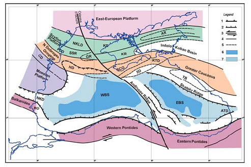
The Black Sea is one of the largest enclosed seas in the world: its area is about 4.2x10⁵ km 2 , the maximum water depth - 2.212 m, the total water volume of 534,000 km 3 and the volume of anoxic deep water contaminated with H 2 S (see Chemistry study sheet), below the depth of 150-200 m, 423,000 km 3 . The connection of the Black and Mediterranean seas is limited to the Bosphorous- Dardanelles system of straits. The Bosphorous is a rather narrow (0,76 – 3,6 km wide) and shallow strait (presently 32 – 34 m at the sill) restricting the two-way water exchange between the brackish Black Sea (the salinity of the Black Sea water is about 17‰ at the surface and 22 ‰ at the bottom) and the very saline Mediterranean Sea (38 – 39 ‰). The Black Sea basin can be divided into four physiographic provinces: shelf (about 29.9% of the total area of the sea), basin slope (27.3%), basin apron (30.6%), and abyssal plain (12.2%) (fig.1). |
|
A physiographic province is a region in which all parts are similar in geologic structure and which has consequently had a unified geomorphic history; a region whose pattern of relief features or landforms differs significantly from that of adjacent regions |
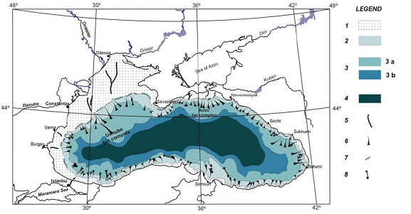 |
Fig. 1 – Geomorphologic zonation of the Black Sea (after Panin & E. and G. Ion, 1997)
Legend; 1, continental shelf; 2, continental slope; 3, basin apron: 3 a - deep sea fan complexes; 3 b - lower apron; 4, deep sea (abyssal) plain; 5, paleo-channels on the continental shelf filled up with Holocene and recent fine grained sediments; 6, main submarine valleys - canyons; 7, paleo-cliffs near the shelf break; 8, fracture zones expressed in the bottom morphology.
|
One of the most prominent physiographic features is the very large shallow (less than 200 m deep) continental shelf within the north-western Black Sea (about 25 % of the total area of the sea).
The Black Sea is located within a complex of high folded mountain chains of the Alpine system, which is represented by the Balkanides-Pontides belt to the south and by Caucasus , Crimea and the North Dobrogea Mountains to the north, north-east and the north-west respectively. Only in the north-west, there are low-standing plateaux and the Danube delta lowland.
Geologists consider the Black Sea a back-arc marginal extensional basin, which originated from the northward subduction of the Neo-Tethys along the southern margin of the Eurasian plate under a Cretaceous-Early Tertiary volcanic arc, as a result of the northward movement of the Arabic plate (fig.2).
|
Fig.2 – Tectonic sketch of the Black Sea Region (after Dinu et al., 2003; Panin et al., 1994)
Legend: 1, Orogene overthrust front; 2, Gravitational faults of the rift; 3, Major strike-slip faults; 4, Major faults; 5, Limits of depressions and/or ridges; 6, Zone without granitic crust; 7, Thinned crust.
Explanation of abbreviations : I. Platform regions: East European, Scytian, Moesian: II. Orogenic regions: North Dobrogea Orogene, Greater Caucasus, South Crimea Orogene – SCO, Balkanides, Western and Eastern Pontides ; III. Depressions and ridges: PDD – Pre-Dobrogean Depression; NKLD – North Kilia Depression; KD – Karkinit Depression; HD – Histria Depression; SD – Sorokin Depression; KTD – Kerci-Taman Depression; NKD – Nijne-Kamchiisk Depression; BD – Burgas Depression; ATD – Adjaro-Trialet Depression; TB – Tuapse Basin; SSR – Suvorov-Snake Island Ridge; KR – Krymskyi Ridge; AR – Azov Ridge; GR – Bubkin Ridge; IV. WBS – Western Black Sea ; V. EBS – Eastern Black Sea ; |
|
Continental shelf: Shallow, gradually sloping zone extending from sea margin to a depth at which there is marked or rather steep descent into ocean depths down continental slope.
Back-arc marginal basins are a feature associated with the collision between an oceanic and a continental tectonic plate. Volcanic arcs are lines of volcanoes associated with the zone of collision. |
| Since about 120 million years ago, the area has been a sea basin, with extremely dynamic development and huge sediment accumulation up to 13 km of bottom sediment thickness in the central part of the basin. In the Black Sea, there are two extensional sub-basins with different geological history (Fig.2): the Western Black Sea Basin, which was opened by the rifting of the Moesian Platform some 110 Ma ago (Late Barremian) followed by major subsidence and probable oceanic crust formation about 90 Ma ago (Cenomanian) and the Eastern Black Sea Basin, with rifting beginning probably in the Late Palaeocene (about 55 Ma ago), and extension and probable oceanic crust generation in the Middle Eocene (ca.45 Ma ago). |
Ma = Millions of years
Ka = Thousands of years
BP = Before Present |
| Past Environmental and Sea Level Changes in the Black Sea |
|
Large-scale sea level changes and consequently drastic reshaping of land morphology, large accumulation of sediments in the deep part of the sea and modifications of environmental settings occurred all along the Black Sea geologic history. The Quaternary was especially characterised by very spectacular changes, which have been driven by the global glaciations and de-glaciations.
During these changes the Black Sea level behaviour was influenced by the restricted connection with the Mediterranean Sea through the Bosphorous – Dardanelles straits. When the general sea level lowered below the Bosphorous sill, the further variations of the Black Sea level followed specific regional conditions, without being necessarily coupled to the ocean level changes. One of the main consequences of the lowstands was the interruption of the Mediterranean water into the Black Sea , which became an almost freshwater giant lake.
The main glacial periods of the Quaternary in Europe corresponded to the regressive phases of the Black Sea , with lowstands of the water level down to –120 m. As mentioned above, the regressions represent phases of isolation of the Black Sea from the Mediterranean Sea and the World Ocean . Only the connection with the Caspian Sea could sometimes continue through Manytch valley. Correspondingly, during regressions, under fresh water conditions, the particularities of fauna assemblages had a pronounced Caspian character. On the contrary, during the inter-glacials, the water level rose to levels close to the present level; the Black Sea was reconnected to the Mediterranean sea , and the environmental conditions as well as the fauna characteristics underwent marine Mediterranean influences.
or example, during the Karangatian phase (since 125 ka BP to ~ 65 ka BP) of the Black Sea , which corresponds to the warm interglacial period (fig.3), the water level exceeded the present-day level by 8 to 12 m . The saline Mediterranean water penetrated through the Bosphorous, and the Black Sea became saline, covering the lowlands in the coastal zone. |
The Quaternary began 2 to 3 million years ago and extends to the present. It consists of two grossly unequal epochs; the Pleistocene, up to about 10,000 years ago, and the Holocene since that time. The Quaternary was originally designated an era rather than a period, with the epochs considered to be periods, and it is still sometimes used as such in the geologic literature.
|
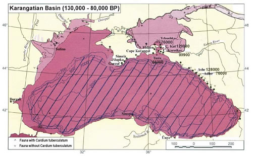 |
Fig.3 – Paleo-geographic reconstruction of the Black Sea during the Karangatian phase (Riss-Wurmian or Mikulinian interglacial) (After Tchepalyga, 2002) |
The last Upper Wurmian glaciation (Late Valdai, Ostashkovian) corresponds to the very low-stand phase of the Black Sea, when the shoreline moved far away from the present-day position, especially in the north-western part of the Black Sea, and large areas of the continental shelf were exposed (fig.4).
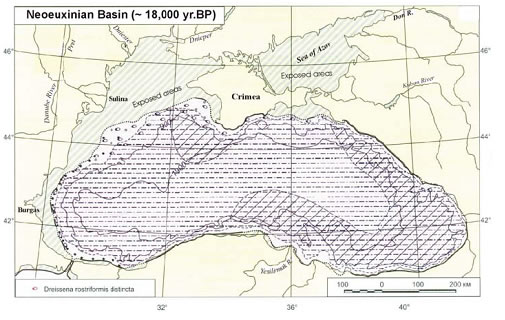 |
Fig. 4 – Palaeo-geographic reconstruction of the Black Sea during the Neoeuxinian phase ( Upper Wurmian ) (After Tchepalyga, 2002) |
At the beginning of the Holocene, some 9-7.5 ka BP, when the Mediterranean and the Black Seas have reached the same level (close to the present day one), the two-way water exchange was established, and the process of transformation of the Black Sea in an anoxic brackish sea started.
In the late 1990s, a new hypothesis was formulated by Ryan, Pitmann et al. (1997). The authors consider that, when the de-glaciation started during a short episode, the level of the Black Sea was high enough, and the fresh Pontic water flowed towards the Aegean Sea . At about 12 k.yr BP, the retreat of the ice-sheet front determined the reorienting, for a limited period of time, of the melt-water supply towards the North Sea . The Black Sea, without the income of the ice-melting water during the Younger Drias cooling (~11 ka BP) until 9 ka BP, under more arid and windy climate, experienced a new lowering of the level (down to -156 m). At the same time, the Mediterranean Sea continued to rise, reaching by 7.5 K.yr BP the high of the Bosphorous sill, and generating a massive input of salt water into the Black Sea basin. The flux was several hundred times greater than the world's largest waterfall, and it caused a rise of the level of the Black Sea , some 30 to 60 cm per day topping up the basin in few years time.
This new hypothesis is still under debate: numerous data from the straits of Bosphorous and Dardanelles , Marmara and Aegean seas and the Danube Delta do not support the new Ryan's hypothesis. These data indicates that the “classical” scenario of Black Sea water outflow is rather credible. There are also some hydraulic incompatibilities for accepting a catastrophic flooding event in the Black Sea , as well as a different time scale for reaching the present day salinity of the Black Sea waters. |
| Water and Sediment River Supply |
The Black Sea has an enormous drainage basin of more than 2 million km 2 , collecting the water from almost all the European countries, except the westernmost ones. The north-western Black Sea receives the discharge of the largest rivers in Black Sea drainage area – the Danube River with a mean water discharge of about 200 km 3 /yr and the Ukrainian rivers Dniepr, Southern Bug and Dniestr contributing with about 65 km 3 /yr (Table 1).
Rivers |
Length (Km) |
Drainage basin Area (Km 2 ) |
Water discharge (Km 3 /yr.) |
Sediment discharge (Mt/yr.) |
I. North-Western Black Sea |
• Danube |
2,860 |
817,000 |
190.7 |
51.70** |
• Dniestr |
1,360 |
72,100 |
9.8 |
2.50* |
• Dniepr |
2,285 |
503,000 |
52.6 |
2.12* |
• Southern Bug |
806 |
63,700 |
2.6 |
0.53* |
Sub-total I: |
|
1,455,800 |
255.7 |
56.85 |
II. Sea of Azov |
• Don |
1,870 |
442,500 |
29.5 |
6.40* |
• Kuban |
870 |
57,900 |
13.4 |
8.40* |
Sub-total II: |
|
500,400 |
42.9 |
14.80 |
III. Caucasian coast rivers |
|
|
41.0* |
29.00* |
IV. Anatolian coast rivers |
|
|
29.7 |
51.00* |
V. Bulgarian coast rivers
|
|
|
3.0* |
0.50* |
T O T A L : |
|
|
372.3 |
152.15 |
Table 1. Fluvial water and sediment discharge into the Black Sea
*Data from Balkas et al., 1990; ** multiannual mean discharge before damming the River Danube after Bondar, 1991; Panin, 1996.
Presently, the Danube influence is predominant for the sedimentation on the north-western Black Sea shelf area. The Danube role extends far southward up to the Bosphorous region, as well as down to the deep sea floor. The other three tributaries of the north-western Black Sea (Dniestr, Dniepr and Southern Bug ) are time not significant suppliers of sediments presently because they are discharging their sedimentary load into lagoons separated by beach barriers from the sea. After the damming of the Danube river at Iron Gates I and II the river sediment discharge diminished by almost 40-45 % and the real sediment load brought by the Danube into the Black Sea is not larger than 30-40 million t/yr, of which only 10-12 % is sandy material, which takes part at the littoral sedimentary budget of the delta front zone. |
| Changing Coastline of the Black Sea |
The length of the Black Sea shoreline is about 4,100 Km. The Black Sea coastal zone can be divided in 17 main zones characterised by different geology and morphology, as well as specific littoral water circulation, sediment drift systems and sedimentary budget. In a more general approach the Black Sea coast zone could be subdivided into three main morphodynamic categories, with very specific characteristics and behaviour: (1) Low, accumulative coasts mostly related to the main rivers mouth zones; (2) Erosive coasts within low standing plateaux and plains, with active cliffs in loess and loess-like deposits sometimes with very narrow beaches in front of the cliffs; (3) Mountainous coasts, with cliffs, certain number of marine terraces, land slides, sometimes with sandy or gravely beaches.
The coastal erosion in the Black Sea represents one of the main environmental concerns of the riparian countries: Bulgaria , Georgia , Romania , Russian Federation , Turkey and Ukraine . The erosion is controlled by: |
Morphology (in geology) is the observation of the form of lands
A terrace is a nearly level surface, relatively narrow, bordering a body of water and terminating in a steep bank |
• Global and natural factors. The coast erosion will depend on synergetic effect of factors controlling the littoral processes (meteorological regime, wave energy regime, water circulation, sediment supply and drift etc.), global changes and the consequent modification of the energetic level of the coastal sea, general sea level rise and regional characteristics as shoreline morphology, elevation and geologic constitution, subsidence or/ and neotectonic regime.
• Anthropogenic factors. The coast zone erosion and the state of the coastal sea ecosystems are strongly affected by the anthropic activities, the effect of which is added to the impact of natural factors. The anthropogenic changes of large rivers hydrologic characteristics (water and especially sediment supply, regularisation of floods etc.), men-made littoral structures as breakwaters, dykes, harbours etc. which are modifying the littoral circulation cells, the uncontrolled use of beach sand, dredging of sand too close to the beaches or within the river mouth bars and many other activities are causing an enhancement of coastal erosion and endangering of the coastal ecosystems. |
 |
|
Anthropogenic refers to changes caused by humans. |
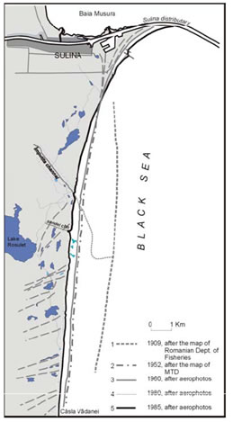
The low, accumulative coasts (the first category described above) are the most influenced by the global changes, specifically by the sea level changes and by the changes in the river sediment inputs. The decreasing of sediment supply and changes in littoral sediment drift due to anthropic activities (river damming, hydrotechnical regularisation, littoral structures etc.), especially when the sandy beaches are low, added to the rising of the sea level and the increasing of littoral sea energy could determine in certain conditions a very active and almost continuous recession of the beach line up to 20-30 m/y, as it happens in some sections within the Danube Delta littoral (fig.5). This process is causing land losses, environmental changes and economic degradation of the coastal zone. If the region represents the coastal zone of an important delta, which plays essential role in the normal structuring, and functioning of ecosystems, any changes of delta/sea interaction zone environments could be fatal and irreparable. |
|
| Archaeological evidences of environmental changes in the Black Sea. |
It is obvious that the ancient populations were influenced by different environmental changes. The people migrations were also driven in many cases by such changes. The coastal zone excursions accordingly to the sea level position were, probably, followed by migrations of Palaeolithic and Neolithic settlements, which searched favourable live conditions along the valleys or by the littoral zone. It might be that at the Neoeuxinian (Wurmian) regression of the sea when the entire continental shelf zone was exposed (the water level at about –120 m) the Upper Palaeolithic or Epi- Palaeolithic settlements were located far away offshore from the present-day coastline. The assessment of these settlements, which are in most of cases buried under a blanket of recent and Holocene sediments, is very difficult and little is known about them.
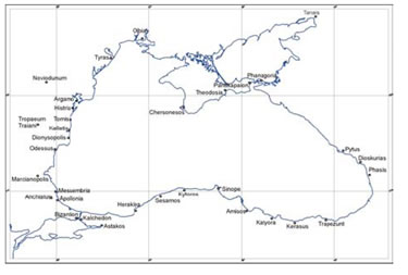 |
| Fig.6 – Greek colonies around the Black Sea established in 7 – 5 centuries BC |
On the contrary, for the last 2000 to 3000 years there is a large and useful information about the sea-level changes and coastline position in many areas. There is also information about the coastline and palaeo-geography in different places around the Black Sea . The ancient Greeks and Romans in their expansion eastward gave very interesting description of Black Sea coast zone connected mainly with the colonies established since the 7-th century BC (fig.6). One of the best-described areas was the Danube Delta and lagoons and the Danube River mouth zone. |
|