|
South China Sea Project on Google Earth |
|
Written by Chris Paterson
|
|
Saturday, 01 December 2007 |
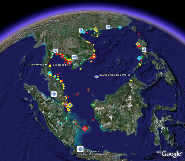
UNEP/GEF South China Sea Project on Google EarthThe wide range of outputs and information generated through the UNEP/GEF South China Sea Project can now be explored on Google Earth. In order to use this new feature of UNEPSCS.org, you must first install Google Earth. Click here to download Google Earth. The South China Sea Project layer on Google Earth features the project’s institutional network, suite of habitat demonstration sites, and a large number of site characterisations for coastal habitat areas in the South China Sea and Gulf of Thailand. The layer is linked to all related documents and databases on UNEPSCS.org. Click here to view the South China Sea Project on Google Earth. The layer can also be accessed via the Google Earth Outreach Showcase. Google Earth’s Outreach Programme provides a variety of templates and instructional guides on how to best make use of Google Earth for extending information about the work of your organisation or project to the global community of Google Earth users. Click here to learn more about Google Earth Outreach. Figure 1. A screenshot of the UNEP/GEF South China Sea Project Layer on Google Earth |
|
|
Last Updated ( Sunday, 24 February 2008 )
|
|
|
SCS Geographical Information System |
|
Written by Christopher John Paterson
|
|
Monday, 16 January 2006 |
The South China Sea Geographical Information System 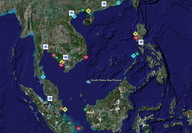 The UNEP/GEF South China Sea Project Geographical Information System (SCS GIS) was developed to facilitate the online sharing and update of information and data for coastal habitat sites in and bordering the South China Sea. It is anticipated that this GIS will be built upon during the implementation of the revised Strategic Action Programme for the South China Sea from 2009-2013. The UNEP/GEF South China Sea Project Geographical Information System (SCS GIS) was developed to facilitate the online sharing and update of information and data for coastal habitat sites in and bordering the South China Sea. It is anticipated that this GIS will be built upon during the implementation of the revised Strategic Action Programme for the South China Sea from 2009-2013.
The SCS GIS contains information and data for the project’s network of habitat demonstration sites and more than 135 habitat sites characterised during the South China Sea Project. Users can access data for mangrove, coral reef, seagrass, and wetland sites by following the main links on the GIS page and by clicking on site icons to display data rich information bubbles.
A key feature of the SCS GIS is that data for all existing and new sites can be submitted to the GIS via the GIS Update Page Following review and approval by regional experts this data will be available automatically via the GIS page. This user-friendly update procedure is based on the Google Earth interactive mapping system.
A full layer for the South China Sea Project can be viewed on Google Earth by visiting the Google Outreach Showcase or by loading directly in Google Earth by clicking here. Please contact the Project Coordinating Unit for any further information.
|
|
Last Updated ( Monday, 08 September 2008 )
|
|
|
Nutrient Carrying Capacity Model |
|
Written by Christopher John Paterson
|
|
Monday, 16 January 2006 |
Coastal blooms of phytoplankton induced by land-based nutrient loading was cited in the TDA Report as one of the top priority impacts of land-based pollution in the South China Sea. However, it was recognised that different marine areas could have different capacity to assimilate nutrients and therefore not all nutrient delivered from nearby land masses will result in such blooms.  Carrying capacity can be estimated by several approaches, some are qualitative while others can be very quantitative. The South China Sea Project adopted a quantitative modeling approach, and Dr. Anond Snidvongs conducted research in support of the Project that was aimed at quantitatively linking surface phytoplankton biomass as indicated by chlorophyll and surface water concentration of dissolved oxygen with nutrient loading by rivers. Once the model was satisfactorily calibrated, assimilation capacity was estimated by perturbing the system with some imaginary loading scenarios. A valuable output of this South China Sea Project activity is a gridded (raster) based chlorophyll modelling system as a functional response to land-based nutrient loading that runs entirely on Microsoft Excel (including data management, numerical solving and geospatial visualisation). This South China Sea Nutrient Carrying Capacity model can be accessed by clicking here. A comprehensive user manual outlining the procedures for downloading model data from UNEPSCS.org, running the model, and modifying nutrient loading scenarios can be accessed by clicking here. While considerable effort has gone toward making this tool as useful as possible, we welcome constructive feedback on how the interface or user manual might be improved. Users are encouraged to contact the PCU in the case of any error, or to suggest additional information that might be useful. Please forward your comments to the Director of SEA START RC,
This e-mail address is being protected from spam bots, you need JavaScript enabled to view it
, or the South China Sea Project's Fisheries Expert,
This e-mail address is being protected from spam bots, you need JavaScript enabled to view it
. |
|
Last Updated ( Sunday, 10 September 2006 )
|
|
|
Written by Christopher John Paterson
|
|
Monday, 16 January 2006 |
South China Sea Projects Database During the preparatory phase of the South China Sea Project, project component focal points compiled information on past and on-going coral reef, seagrass, mangrove, wetland, fisheries, and land-based pollution projects implemented in areas of the South China Sea and Gulf of Thailand. This Projects Database has been developed to provide a facility for the efficient online storage and searching of this information online.
The Projects Database is a “living” database. Project Partners can revise and add information to the database via a secure online login. Partners can also easily add information about new projects as it becomes available. Other organisations can also contribute information by registering for a user account.
This tool is still under development, requiring the addition of project information and further development of several key functions. This interface has been made publicly available online for the collective review by the South China Sea Project Network. Please direct any comments to the PCU Fisheries Expert, Christopher Paterson.
It is anticipated that the completed version of this tool will be reviewed in detail by the Eighth Meeting of the Regional Scientific and Technical Committee in December 2007. The comments of this committee will be used to produce a final version of the Projects Database by the end of this year. 
The Prototype Projects Database for the South China Sea - http://projects.unepscs.org |
|
Last Updated ( Tuesday, 17 July 2007 )
|
|
|
Database Template - Metadatabase |
|
Written by Christopher John Paterson
|
|
Monday, 16 January 2006 |
Template for the South China Sea Project Meta-Database The South China Sea Meta-Database is a central online location for the collation and searching of metadata regarding coastal habitats and fisheries in Southeast Asia.  It is also a “living” database that is being continously revised and updated online. Development of the SCS Metadatabase is a collaborative effort of the UNEP/GEF South China Sea project, Southeast Asia Regional Learning Centre (SEA-RLC) and the Southeast Asia START Regional Centre (SEA START RC). It is also a “living” database that is being continously revised and updated online. Development of the SCS Metadatabase is a collaborative effort of the UNEP/GEF South China Sea project, Southeast Asia Regional Learning Centre (SEA-RLC) and the Southeast Asia START Regional Centre (SEA START RC).
The South China Sea Meta-Database has now been packaged as a template for other projects and organisations that seek to develop a similar web-based meta-database tool. Download the following files to install and customise the UNEP/GEF South China Sea Meta-Database.
REQUIRED FILES:
1. Metadatabase_archive_final.tar.gz
This contains the 'metadata' directory, 'metadata.sql', guidelines for installing and customising, and copyright/licensing details of files. The guidlines provide instructions for installing and customising the SCS Meta-Database on Windows (Section 1) and Linux (Section 2) operating systems:
2. phpMyAdmin-2.8.0.tar.gz (for Linux installation)
(More recent versions can be downloaded from: http://www.phpmyadmin.net/home_page/index.php Licence: GNU General Public License).
3. appserv-win32-2.4.5.exe - download a recent version from http://www.appservnetwork.com.
4. You also need to copy a file called 'coolRedirect.js' into the 'metadata' directory - download and unzip 'cool-redirect.zip' from http://www.codehouse.com/javascript/scripts/cool_redirect/.
While considerable effort has gone toward making the guidelines as useful and accurate as possible, we welcome constructive feedback on how they might be improved. Users are encouraged to contact us in the case of any error, or to suggest additional information that might be useful. Please forward your comments to SEA-RLC’s Environmental Information Manager, Dr. Richard Cooper, or the South China Sea Project's Fisheries Expert, Mr. Christopher Paterson. |
|
Last Updated ( Sunday, 10 September 2006 )
|
|
|
|