


| PROGRAMMES | PROE | PUBLICATIONS, LIBRARY and IRC | SITE MAP | SPREP FORUMS | WEBMAIL - Global / Local | CONTACT | HOME
| Search |
Home > Publications, Library & IRC
SPREP LIBRARY & INFORMATION RESOURCE CENTRE
Tsunami 2009 clearinghouse
http://www.sprep.org/publication/tsunami_2009.asp
"A clearinghouse of environment related documents relating to
the 29 September tsunami that affected Samoa, American Samoa and Tonga"
** see also 'Pacific
Disaster Net' Samoa and Tonga Tsunami clearinghouse
http://www.pacificdisaster.net:8080/Plone/samoa-tsunami/
Contents
Background Information to the earthquake and tsunami
Environmental Impact Assessments and recovery plans
Other reports
Maps
Photographic images of tsunami impacts
Further information and resources - including
'best practices' and 'lessons learned '
Background information to the earthquake
and tsunami
SAMOA Tsunami Event Tue, 29 Sep 2009 17:48 UTC [Global Atlas]
The
Global Disaster Alert and Coordination System flash report
The Global Disaster Alert and Coordination System List of calculations
performed for the Samoa event of 29/9/2009
The
Global Disaster Alert and Coordination System event report
Samoa tsunami caused by geologic features similar to Pacific Northwest
... more situation reports available from Pacific Disaster Net
see also NOAA Centre for Tsunami Research - Tsunami Event - September 29, 2009 Samoa
Environmental Impact Assessments and recovery plans
(i) Post-tsunami
coastal resource damage assessment. Tutuila, American Samoa. October 2009
(ii)
Samoa tsunami rapid Environmental Impact Assessment (EIA) recommendations
(October 3rd to 7th 2009)
(iii) Samoa tsunami
rapid environment impact assessment report [draft] October 14th 2009
(iv) SAMOA TSUNAMI:
Preliminary Survey Report on Bulky Wastes & Sewage Conditions At the Affected Villages of Aleipata & Lepa Districts
(v) Early Recovery
Framework : Submitted to the Prime Minister of Samoa - October 2009
(vi) UNESCO-IOC International
Tsunami Survey Team Samoa (ITST Samoa) Interim Report of Field Survey
14th – 21st October 2009
(vii) Coral Reef Inspection
of Selected Coral Reefs on Upolu Samoa following the September 29, 2009
Tsunami
(viii) Marine Turtles
Stranded on Land after the Samoa Tsunami
(ix) THE SOUTH PACIFIC ISLANDS EARTHQUAKE AND TSUNAMI OF 29TH SEPTEMBER 2009
: A PRELIMINARY FIELD REPORT BY EEFIT
... more assessments / surveys available from Pacific Disaster Net
(i) Post-tsunami coastal resource damage assessment. Tutuila, American Samoa. October 2009
This report documents a rapid coastal resource assessment of Tutuila in the days immediately following the earthquake and tsunami on September 29, 2009. The main focus of the assessment was on coastal and marine debris that could impact territorial coastal resources as well as on environmental health issues such as oil spills, septic systems and piggeries.
Summary and Recommendations:
Overall, it appears that there are no urgent environmental health concerns
although a number of items will require significant attention during the
coming weeks to ensure that ecological impacts are minimized. The most
severe damage was found at Poloa, Amanave, Leone, Pago Pago, Alao, and
Tula although widespread damage was also reported from Masefau, Vatia,
Amaluia, and Asili.
Marine and coastal debris is going to need extensive manual labor to assist with removal. Ideally, SCUBA divers would be used to check for sunken debris in deeper water, such as pieces of tin roof, as the longer the debris is left in the environment, the more likely coral reef damage is going to occur. Additionally, surveys are currently underway to assess general damage to reefs from the force of the wave although existing staff and equipment is minimal. No severe impacts to wildlife were noted from land other than small to moderate numbers of reef fish washed ashore in certain locations. Nearly all affected coastlines are suitable for staging areas.
Oil spills were noted in Pago Harbor, yet most marine areas seemed to be flushing with wave action or currents. Numerous piles of debris have accumulated along streams and shorelines and there is the potential for great harm to coral reefs should they may allowed to flush onto reef areas. These debris piles need to be cleaned up quickly and efficiently. Additionally, toxic and/or harmful contaminants from these debris piles have yet to be assessed and several small pieces of debris may include chemicals and other potentially hazardous materials. For example, items such as plastic oil bottles, oil drums, car batteries, cars and air conditioning units were noted along several shorelines. Additionally several small boats and vehicles were noted in or adjacent to shoreline areas and it remains unclear if any are leaking contaminants
Context
The environment sub-cluster was tasked by the Prime Minister to carry out a rapid environmental impact and needs assessment to be included in the assessment for the Rapid Recovery Cluster. Nearly all coastlines that were affected by the tsunami were visited and systematically assessed with an expert team between October 3rd to 7th 2009 – hence starting four days after the Tsunami itself.
Assessments for remaining small sections of coastline without road access had to rely on aerial photographs. Agriculture (including horticulture) is being assessed by the Ministry of Agriculture and Fisheries in collaboration with FAO and reported on separately. A detailed account of the EIA is appended to the Summary Framework and available from the Apia office of UNEP (contact Dr Greg Sherley care of UNDP).
General Observations
• Significant environmental damage was sustained on the south and east coast of Upolu and Manono island including coastal erosion, salinisation of coastal areas, damage from building debris and pollution from solid waste and sewage in village areas
• Sensitive marine habitats including coral reefs and seagrass beds are expected to have sustained significant damage
• Environmental damage was greatest at the far eastern and southern coast of Aleipata and generally diminished westwards
• Bathymetry and coastal morphology and topography, including distance of reef from shore and the location of channels had a major influence on the damage sustained
• More detailed environmental assessments are needed especially for sensitive marine habitats such as coral reefs and seagrass beds and terrestrial ecosystems such as coastal marshes, mangrove areas and near shore islands.
(iii) Samoa tsunami rapid environment impact assessment report [draft] October 14th 2009
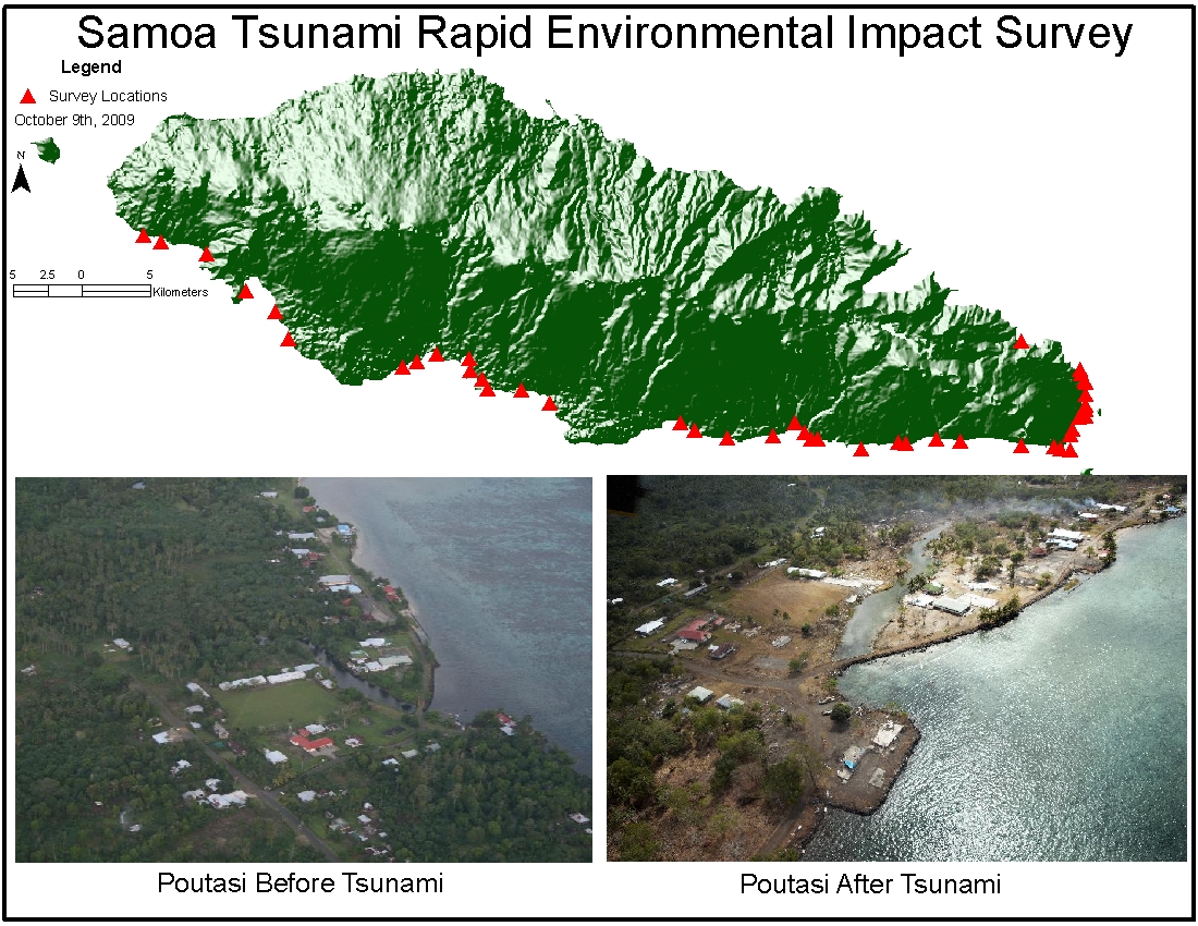
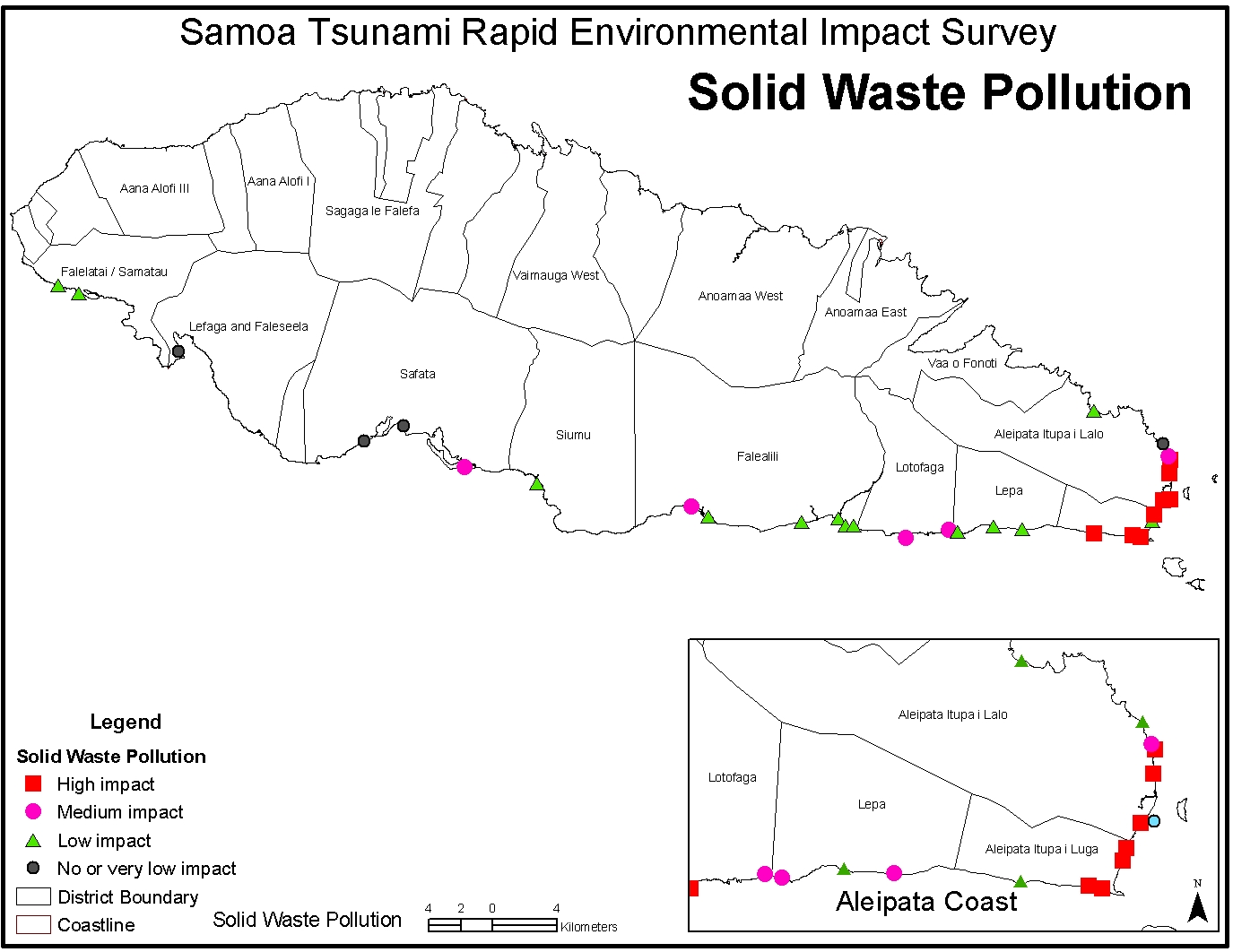
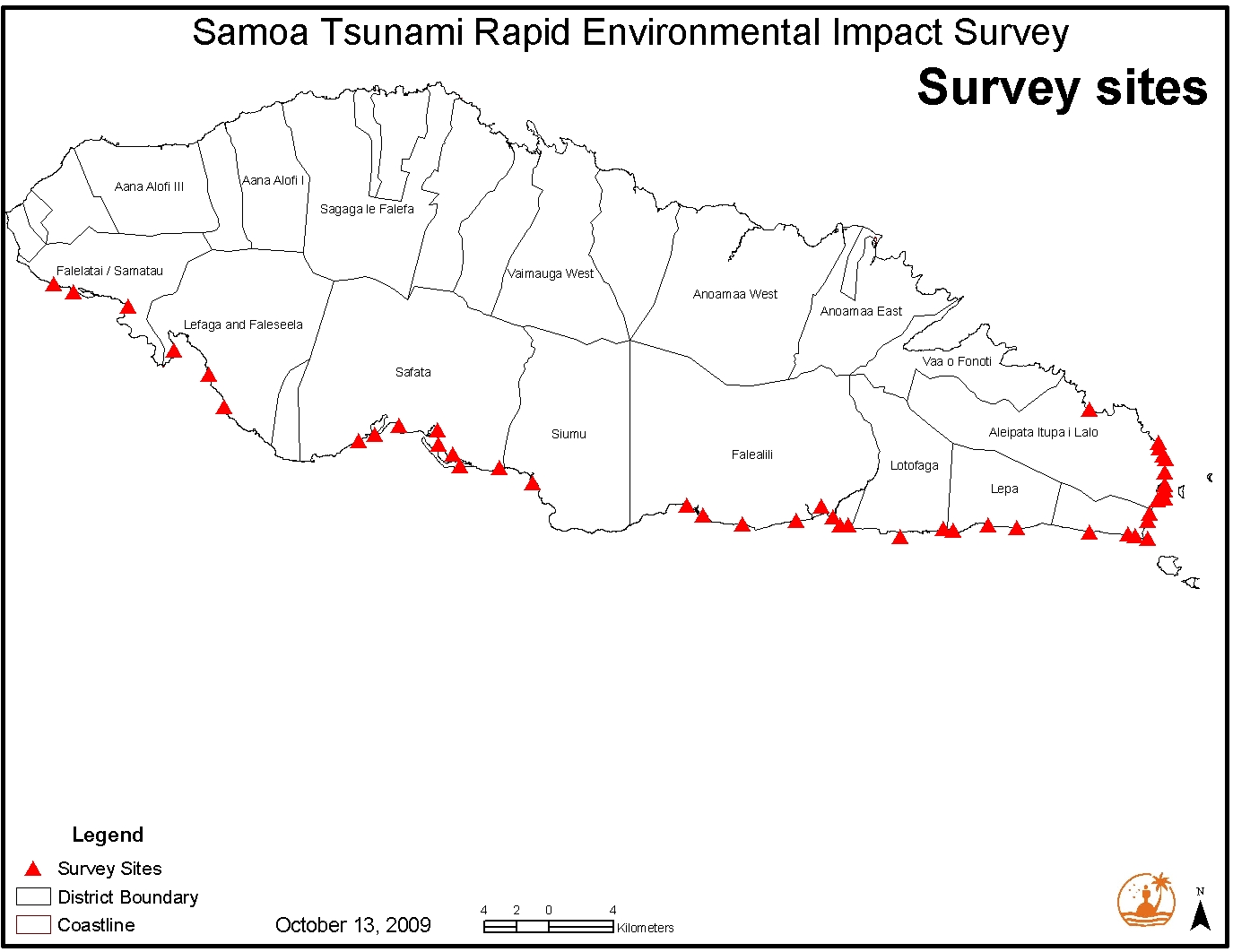
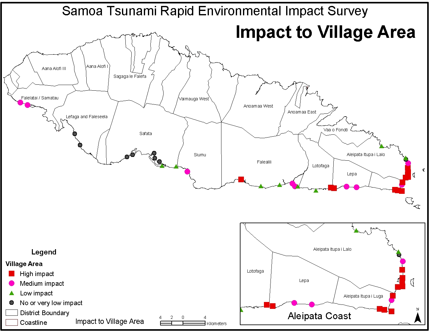
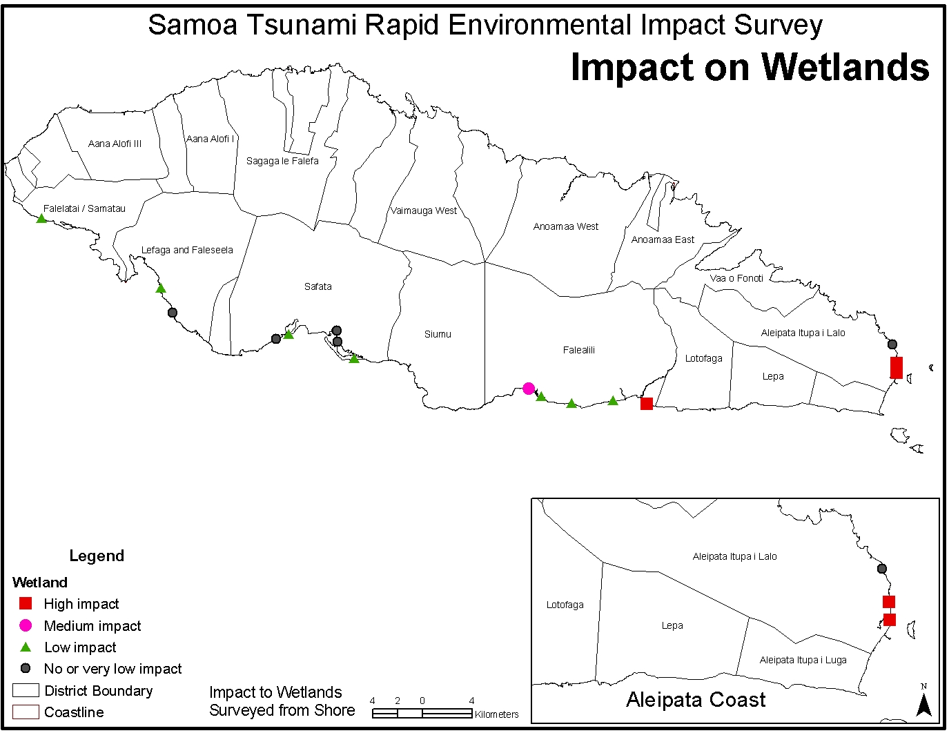
A rapid assessment of the environmental impacts of the 29 September tsunami was conducted by a multi-agency team from 3 to 14 October, 2009. Fourteen “green” and 10 “brown” environmental variables were selected and measured based on the experience of the survey team and similar reports from elsewhere. During a tour of the affected area on Upolu by car and on foot those “assessable” variables were scored “high” (over two thirds affected), “medium” (over one third, less than two thirds affected), “low” (less than a third affected) or zero (unaffected). Manono and Savaii were surveyed by air with the former showing evidence of some damage and the later apparently none or very little. The most affected areas in Upolu were villages in the Aleipata, Lepa and Falealili districts with the most obvious indicators of the tsunami’s impact being solid waste (sometimes resulting from the complete destruction of a village), erosion of the beach and fore-shore and the (expected) impact on marine resources. Other environmental variables assessed also showed similar patterns. Impacts on a wharf/dry dock facility are also described (including lost fuel drums) as are the possible environmental implications of new settlements created by displaced persons (mainly revolving around sanitation, drainage and water supply).
A number of recommendations were identified and categorized as being needed in the short (<3 months) or medium to long term (> 3 months). Strategically the key recommendation for marine habitats is to implement actions that foster the natural recovery and resilience of these areas. Strategically the key recommendation for terrestrial habitats is to implement actions that focus on restoration based on ecological and resilience principles eg replanting with native wave resistant species on the foreshore and ensuring that human developments, rebuilding and associated infrastructure (eg villages, tourism) are undertaken cognizant of both the ongoing tsunami risk and minimizing the environmental impact to both terrestrial and marine habitats.
GENERAL RECOMMENDATIONS:
o Where possible there should be clear coordination over the implementation of the recommendations dealing with marine and terrestrial habitats
o Those recommendations endorsed by the Government of Samoa should identify clear decision making lead agencies, develop clear and costed terms of reference and invite partnerships for resourcing and needed expertise in these from local and overseas organizations.
o Work carried out in the recommendations above should follow normal protocols in Samoa for village and district approvals and participation. Existing governance structure eg MPA District Committees, CIM committees should be used effectively.
o Every effort should be made to capitalize on local expertise and supplement with overseas expertise where needed.
o Coastal Infrastructure Management Plans for affected districts should be revised to include a specific tsunami vulnerability layer and then fully implemented
o New settlements for displaced communities should be planned in a participatory manner and implemented carefully to mitigate potential environmental impacts
o Every effort should be made to collaborate with related activities in American Samoa to maximize benefits and sharing of knowledge
o New settlements for displaced communities should be planned in a participatory manner to mitigate potential environmental impacts
o Every effort should be made to collaborate with related activities in American Samoa to maximize benefits and sharing of knowledge
This report presents the findings of a preliminary survey initiated and conducted by the Japan International Cooperation Agency (JICA) to assess the situation of the generated solid waste and the sewage conditions at the Aleipata and Lepa Districts following the tsunami which hit Samoa on Tuesday, 29th September 2009. The occurrence of the Tsunami event has resulted with the generation of large quantities of solid wastes deposited at 10 villages of the Aleipata and Lepa Districts. Wastes from fallen trees, damaged buildings and furniture as well as other destroyed properties were deposited along the coast towards 200m inland. The toilet facilities at these villages were all destroyed with the contents of most septic tanks being swept away by the waves leaving open ditches, while some partly damaged septic tanks still have active and unstable sludge. Samoa like most of the Pacific Islands does not have any special policy and strategy in place to provide a management framework to respond to such a situation. The findings of this preliminary survey are therefore very important in providing some baseline information and data to assist JICA in its post tsunami relief waste management works.
Early Recovery Framework : Submitted to the Prime Minister of Samoa - October 2009
Executive summary
The goal of the Early Recovery Framework is to present clearly to
Government, donors and the
wider community costed options designed to bring about an early recovery
process that is both
effective in meeting the needs of the population affected by the earthquake
and subsequent
tsunami that occurred on 29 September 2009, and sustainable in the long-term
development of
affected communities and the economy of Samoa.
Designed to address the issues surrounding resettlement, livelihoods and
cross cutting-issues
such as climate change, disaster risk reduction and protection, the purpose
of the Early
Recovery Framework is to assist in bridging the transition period from
the relief phase to the
recovery phase and minimize the impact of future disasters should they
occur. Experience
shows that following the relief phase, investment in affected communities
drops considerably. It
is essential this does not occur, not only because people need to be able
to live in a dignified
manner, with proper housing, adequate opportunities to provide for their
families and decent
local services, but also in light of the imminent cyclone season rapidly
approaching and future
consequences of the adverse impacts of climate change such as sea level
rise. Secondly, it is
imperative that the positive momentum created by relief operations is
carried forward into
rebuilding livelihoods and communities. It is critical that this opportunity
is taken for people to
have cyclone-resistant houses located at a suitable elevation above sea
level and sources of
alternative livelihoods. It is also important that public services such
as health, education, water
and power are accessible and rebuilt at an acceptable standard.
The Early Recovery Framework encompasses a detailed assessment of a range
of sectors and
activities that take into account the capacity, strengths and resilience
of both local communities
and the Government. The key areas of strategic intervention covered are
1) Resettlement and
access to basic social service and infrastructure 2) Livelihoods 3) Disaster
Risk Reduction and
Climate Change and 4) Environment. At the same time, there are synergies
and linkages across
sectors and strategic interventions.
Executive Summary
The tsunami of 29th September 2009 was regionally important within the
SW Pacific, a physical disaster for some communities in Samoa and a psychological
trauma for the whole country. The earthquake that triggered the tsunami
occurred so close to the south coast of Upolu that whilst warning messages
were issued, insufficient time existed for low-lying exposed communities
to fully evacuate. People within communities claim that either they did
not receive a warning message or, that if they did, it came too late.
Further, a confused picture is emerging about people’s stated reaction
to the earthquake, any warning messages, and then the arrival of the tsunami
at the coast. Many people state that for whatever reason, they did not
know how to react. Undoubtedly, the efforts of the Disaster Management
Office (DMO) of the Government of Samoa in recent years mean that many
lives were saved. The ‘take home message’ from our research
is that the Government of Samoa should:
“retain and enhance its community-based tsunami education activities
because they do save lives”
This simple recommendation is underpinned by many more detailed recommendations
that the Government of Samoa may consider for immediate and future possible
implementation to increase resilience to future hazard events...
Introduction
The assessment strategy involved the inspection of several sites of over a four day period. The sites chosen were coral reef areas adjacent to the locations of substantial terrestrial tsunami impact. Islands were inspected for beach erosion particularly for turtle nesting sites. Stranded turtles were also documented. Where possible marine protected areas and fisheries reserves were inspected as there was previous data regarding the nature of the marine benthos. As well, the Coral Reef Recovery Planning (CERP) site of Vaovai was inspected in 2006 providing a before appraisal of the tsunami effect.
(viii) Marine
Turtles Stranded on Land after the Samoa Tsunami [SPREP / MNRE]
1. INTRODUCTION
The tsunami waves that swept through parts of the Samoa Islands on 29
September 2009
brought a lot of marine life with them, portions of which were stranded
on land when the
waves subsided. In addition to the reef fishes of varying sizes, marine
turtles, a few sharks and
dolphins were also stranded. Three dolphins were reportedly stranded but
rescued and
released by villagers with two more that were left on land dead and were
buried. This report
focuses on marine turtles and attempts to give an account on the number
and fate of marine
turtles that were stranded on land after the tsunami waves.
The MPA work in both districts of Safata and Aleipata as well as general
conservation effort
seem to have contributed significantly to the high numbers of stranded
turtles being released
back to the sea. For example, the first turtle that was tagged and released
was brought to the
home of the MPA officer by a construction worker because he knew turtle
conservation is part
of the officer’s tasks. The other four turtles tagged and released
were held by Police Officers
posted in one of the affected villages and communication with SPREP lead
to these being
brought in for tagging and then releasing. The other two turtles that
were tagged and released
were kept by a village in the Aleipata District MPA. The release of other
turtles for which no
information was recorded is believed to be linked to the successful campaign
and positive
response of the communities and individuals to conserve marine turtles.
The UK Earthquake Engineering Field Investigation Team (EEFIT) decided to mount a
reconnaissance mission to the Samoa Islands following this earthquake and resulting tsunami,
in particular to assess the effects of the tsunami. This report presents some of the preliminary
findings of the team; further images from the EEFIT Team field mission are available on the Virtual
Disaster Viewer (www.virtualdisasterviewer.com). This viewer development is an ongoing project
supported by EEFIT and other International earthquake reconnaissance teams. It allows the
visualisation of the geo-referenced photos taken by the team, with pre- and post-earthquake
satellite images for the affected areas as well as mapped faults.
This report represents the preliminary findings from the event and disseminates the factual findings
from the mission, including photographs and other exhibits.
Overview of Humanitarian and Short Term Needs following the Samoa “Earthquake and Tsunami”
Samoa/Tonga • Tsunami Situation Report #6 - Date: 6th October 2009 [United Nations Office for the Coordination of Humanitarian Affairs ]
Samoa tsunami situation report 8. - Date: 13th October [World Health Organisation]
... more
general documents available from Pacific Disaster Net
Environmental assessment maps [Samoa]
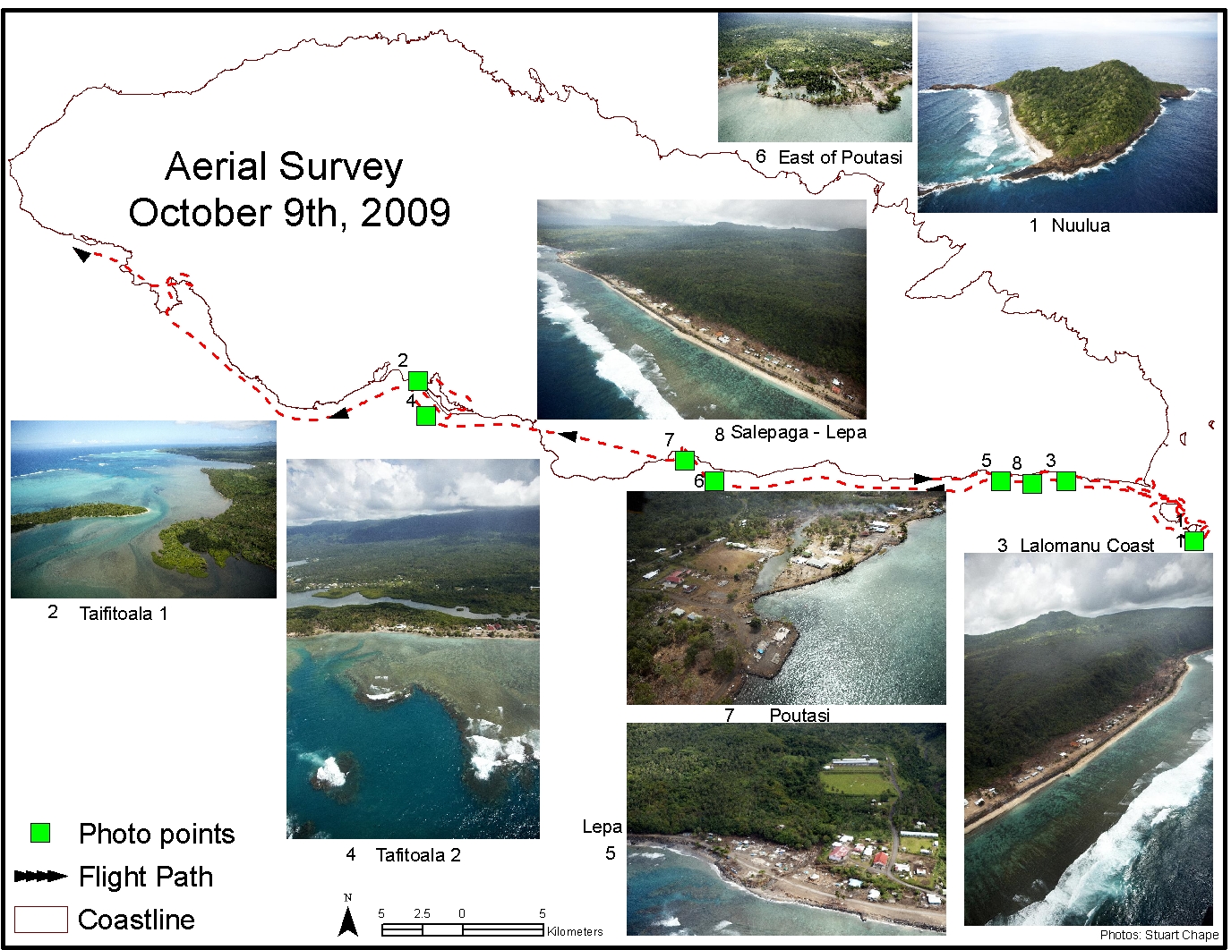
Aerial
Survey
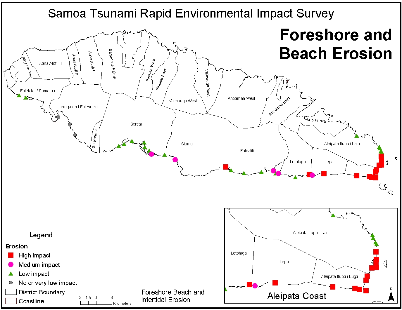
Foreshore
and beach erosion
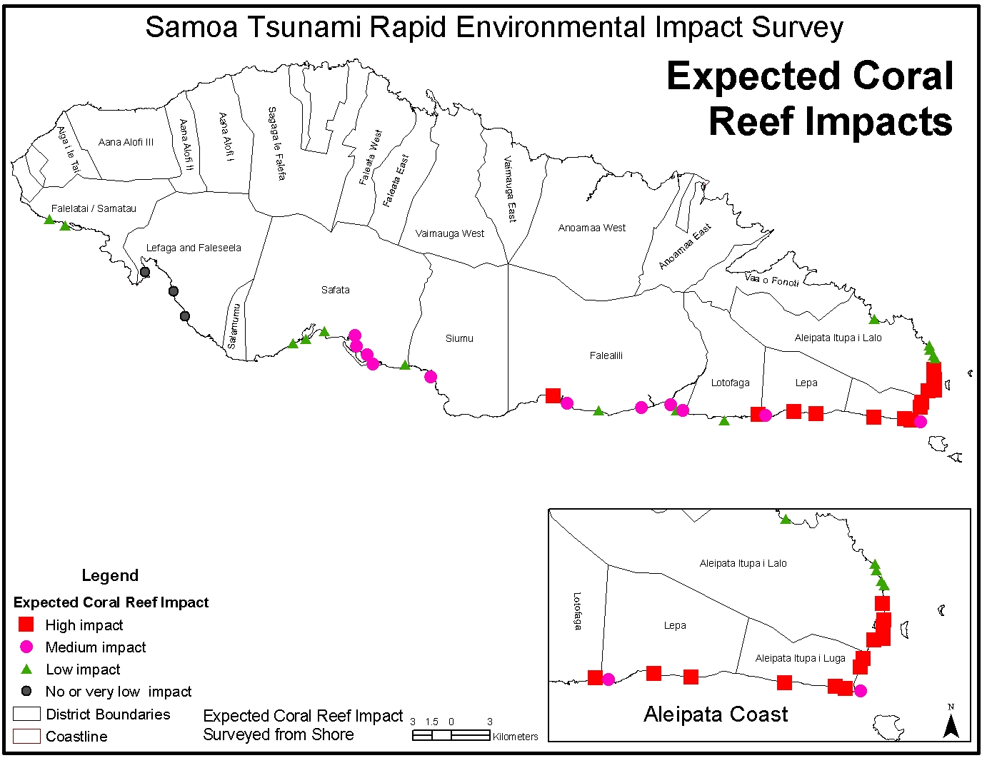
Expected
coral reef impacts
Samoa
tsunami rapid environmental impact survey I
Samoa
tsunami rapid environmental impact survey II
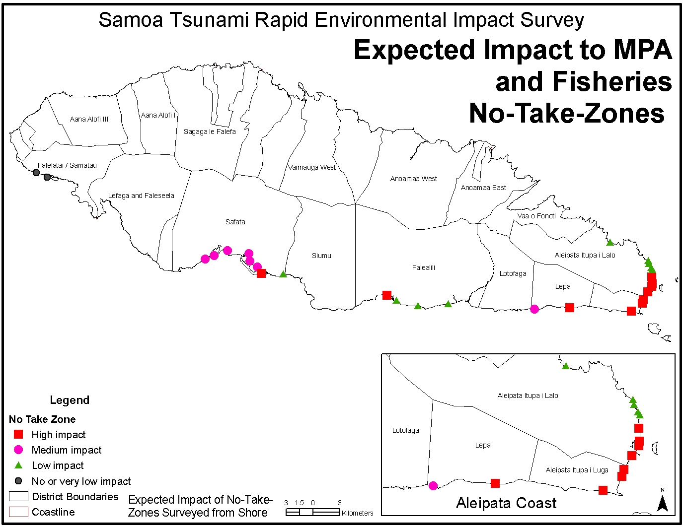
Expected
impact to MPA fisheries and no-take-zones
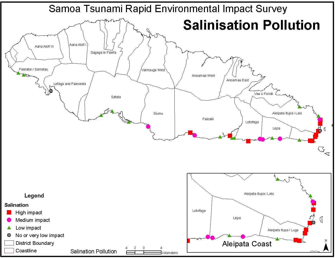
Salinisation
pollution
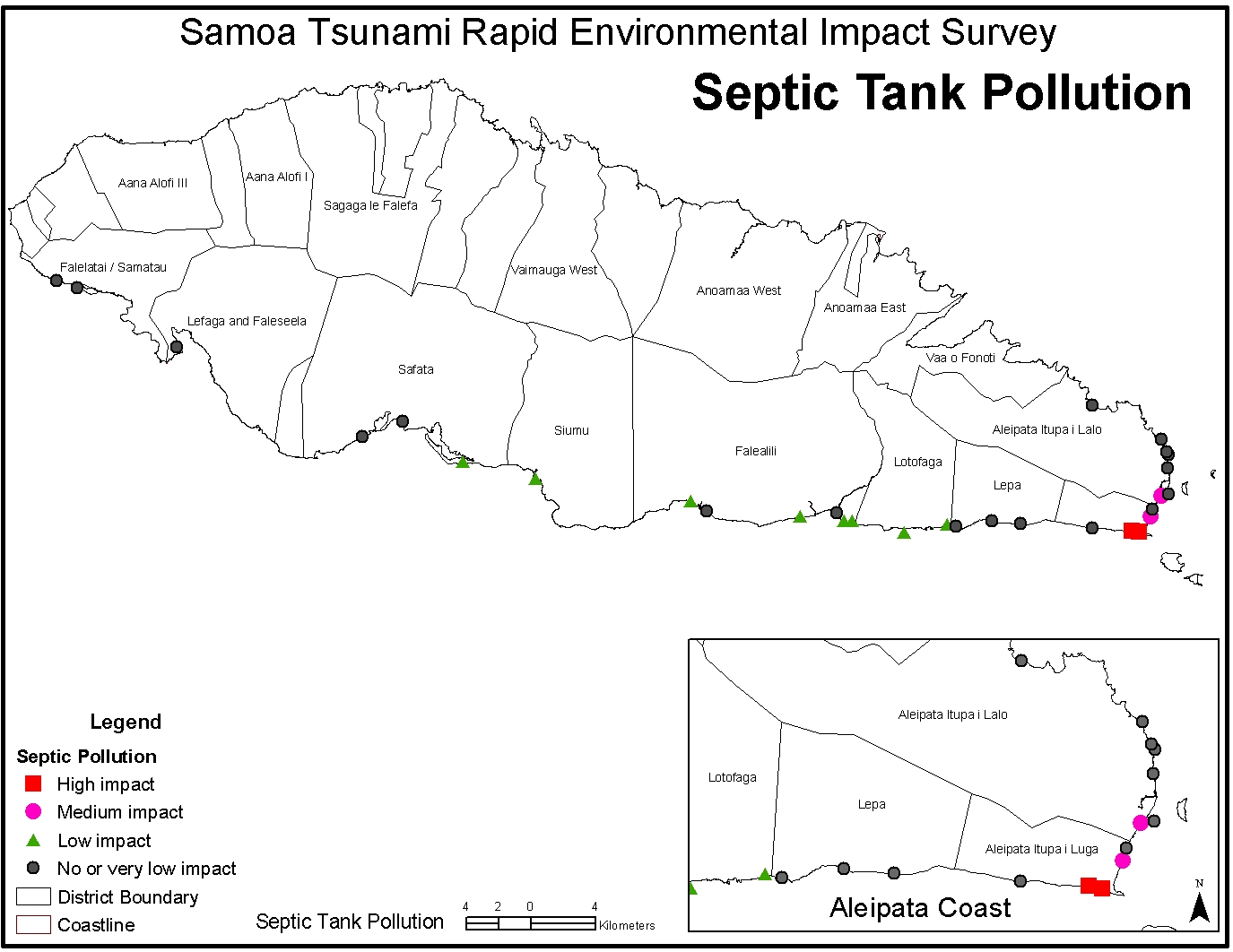
Septic
tank pollution
Solid
waste pollution
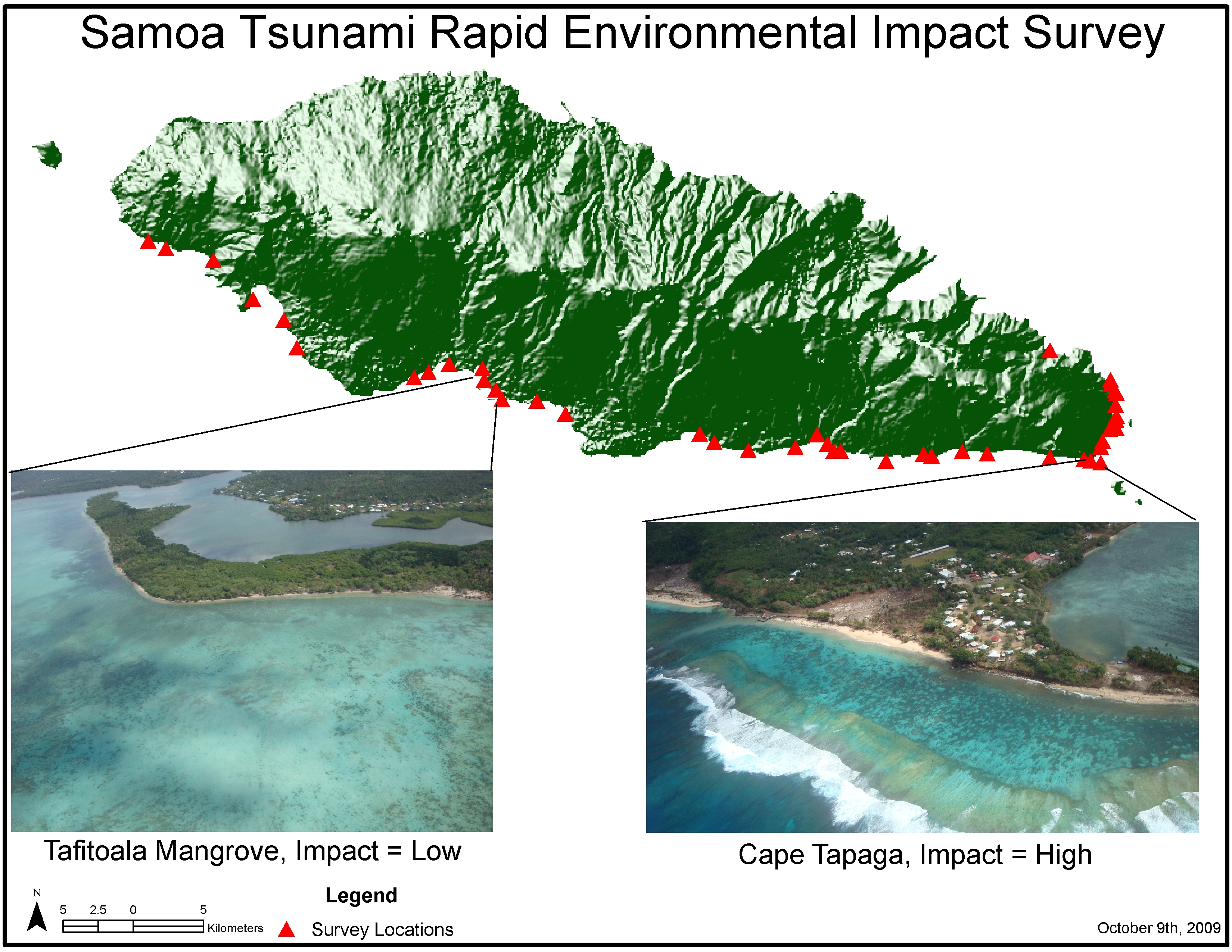
Survey
sites
Impact
to village area
Impact
on wetlands
...more maps available from Pacific Disaster Net
Photographic images of tsunami impacts
Images - I [Keith Frentz, Ted Wells & BECA CIM Plan Project]
Images - II [Stuart Chape, SPREP]
Further information , articles and resources - including 'best practices' and 'lessons learned'
ANNOTATED GUIDING PRINCIPLES for post-tsunami rehabilitation and reconstruction
ICRI Discussions on Environmental Management, Livelihoods And Post Tsunami Reconstruction
Lessons Learned: A Response and Recovery Framework for Post-disaster Scenarios
Samoan
tsunami: impacts to seagrass and coral / Posa Skelton
see also materials referring to the 2004 Asian tsunami:
UNEP Asian Tsunami Disaster clearinghouse
As the United Nations system began addressing the immediate humanitarian
impacts of the Indian Ocean Disaster [2004], many of the affected people
and governments also voiced their concern about the potential environmental
damage and associated risks to human health and livelihoods. To address
these concerns, the countries of Indonesia, Thailand, Sri Lanka, Maldives,
Seychelles, Yemen and Somalia requested the UN Environment Programme (UNEP)
to assist their national experts in understanding the environmental dimension
of the disaster.
Integrating
environmental safeguards into Disaster Management: a field manual
[IUCN]
Volume 1:
Reference manual
Volume 2:
The disaster management cycle
Ecosystems, Livelihoods and Disasters: An integrated approach to disaster risk management [IUCN]
Publications and reports from the Asian Development Bank
see also materials referring to the 2007 Solomon Islands
tsunami
After the earthquake: An assessment of the impact of the earthquake and tsunami on fisheries-related livelihoods in coastal communities of Western Province, Solomon Islands [World Fish Centre / WWF]
Post-Tsunami assessment of Zinoa marine conservation area, South Choiseul, Solomon Islands [Nature Conservancy]
Periodical literature
The 2009 Samoa-Tonga great earthquake triggered doublet / Lay, T.a , Ammon, C.J.b , Kanamori, H.c , Rivera, L.d , Koper, K.D.e , Hutko, A.R. Nature; 2010, Volume 466, Issue 7309, 19 August 2010, Pages 964-968 *
Abstract: Great earthquakes (having seismic magnitudes of at least 8) usually involve abrupt sliding of rock masses at a boundary between tectonic plates. Such interplate ruptures produce dynamic and static stress changes that can activate nearby intraplate aftershocks, as is commonly observed in the trench-slope region seaward of a great subduction zone thrust event1-4. The earthquake sequence addressed here involves a rare instance in which a great trench-slope intraplate earthquake triggered extensive interplate faulting, reversing the typical pattern and broadly expanding the seismic and tsunami hazard. On 29 September 2009, within two minutes of the initiation of a normal faulting event with moment magnitude 8.1 in the outer trench-slope at the northern end of the Tonga subduction zone, two major interplate underthrusting subevents (both with moment magnitude 7.8), with total moment equal to a second great earthquake of moment magnitude 8.0, ruptured the nearby subduction zone megathrust. The collective faulting produced tsunami waves with localized regions of about 12metres run-up that claimed 192 lives in Samoa, American Samoa and Tonga. Overlap of the seismic signals obscured the fact that distinct faults separated by more than 50km had ruptured with different geometries, with the triggered thrust faulting only being revealed by detailed seismic wave analyses. Extensive interplate and intraplate aftershock activity was activated over a large region of the northern Tonga subduction zone.
Field survey of the Samoa Tsunami of 29 september 2009 / Okal, E.A.a , Fritz, H.M.b , Synolakis, C.E.c d , Borrero, J.C.c e , Weiss, R.f , Lynett, P.J.g , Titov, V.V.h , Foteinis, S.d , Jaffe, B.E.i , Liu, P.L.-F.j , Chan, I.-C. Seismological Research Letters ;2010, Volume 81, Issue 4, July 2010, Pages 577-591 *
Field observations of the 29 September tsunami in American Samoa: Spatial variability and indications of strong return / Jaffe, B.E., Richmond, B.M., Gelfenbaum, G.R., Watt, S., Apotsos, A.A., Buckley, M.L., Dudley, W.C., (...), Peck, B. (2009) Eos, Transactions, American Geophysical Union, 90 (52), pp. U21E-2178.
Impact of the 29 September 2009 South Pacific tsunami on Wallis and Futuna / Lamarche, G., Pelletier, B., Goff, J. (2010) Marine Geology, 271 (3-4), pp. 297-302. doi: 10.1016/j.margeo.2010.02.012*
Impacts and Recovery from a Large Tsunami: Coasts of Aceh / Wong, Poh Poh. Polish Journal of Environmental Studies; 2009, Vol. 18 Issue 1, p5-16, 12p, 1 chart, 1 map, 15 color
Great Samoa earthquake (Mw = 8.2) of 29 September 2009 / Lay, T., Ammon, C.J., Kanamori, H. (2009) Eos, Transactions, American Geophysical Union, 90 (53), pp. U21D-05.*
Rupture process of Mw = 8.1 Samoa earthquake constrained by joint inverting teleseismic body, surface waves and local strong motion / Li, X., Shao, G., Ji, C. (2009) Eos, Transactions, American Geophysical Union, 90 (53), pp. U21D-03.
Abstract:The impacts of the 26 December 2004 Indian Ocean tsunami were examined on three separate coastal sectors in the west, north and east of Banda Aceh. The most vulnerable coasts are the soft coasts, such as mangroves, and the least vulnerable are the rocky headlands with the sandy coasts occupying a broad intermediate position. The extent of impact for each category of coasts appears to vary with the tsunami wave height and other characteristics. Coastal recovery was remarkably rapid, especially for sandy beaches. In some cases, foredunes returned to the coast. The impacts and recovery processes provide valuable lessons for coastal management, for example, in the replanting of mangroves and other coastal vegetation in the modified coastal environments and the questionable construction of seawalls on accreting coasts. In years to come, the tsunami impacts would disappear, except for modifications by human activities
Environmental implications for disaster preparedness: Lessons Learnt from the Indian Ocean Tsunami / Srinivas, Hari, Nakagawa, Yuko. Journal of Environmental Management; Oct2008, Vol. 89 Issue 1, p4-13, 10p
Abstract: The impact of disasters, whether natural or man-made, not only has human dimensions, but environmental ones as well. Environmental conditions may exacerbate the impact of a disaster, and vice versa, disasters tend to have an impact on the environment. Deforestation, forest management practices, or agriculture systems can worsen the negative environmental impacts of a storm or typhoon, leading to landslides, flooding, silting, and ground/surface water contamination. We have only now come to understand these cyclical causes and impacts and realize that taking care of our natural resources and managing them wisely not only assures that future generations will be able to live in sustainable ways, but also reduces the risks that natural and man-made hazards pose to people living today. Emphasizing and reinforcing the centrality of environmental concerns in disaster management has become a critical priority, requiring the sound management of natural resources as a tool to prevent disasters and lessen their impacts on people, their homes, and livelihoods. As the horrors of the Asian tsunami of December 2004 continue to be evaluated, and people in the region slowly attempt to build a semblance of normalcy, we have to look to the lessons learnt from the tsunami disaster as an opportunity to prepare ourselves better for future disasters. This article focuses on findings and lessons learnt on the environmental aspects of the tsunami, and its implications on disaster preparedness plans. This article essentially emphasizes the cyclical interrelations between environments and disasters, by studying the findings and assessments of the recent Indian Ocean earthquake and tsunami that struck on 26 December 2004. It specifically looks at four key affected countries — Maldives, Sri Lanka, Indonesia, and Thailand.
Rethinking post-tsunami integrated coastal management for Asia-Pacific / Wong, Poh Poh. Ocean & Coastal Management; Jul2009, Vol. 52 Issue 7, p405-410, 6p
Abstract: The December 2004 Indian Ocean tsunami wrought environmental damage beyond the normal framework of integrated coastal management and has implications for coastal management in Asia-Pacific in the post-tsunami phase. Fieldwork conducted on the coasts of four tsunami-affected countries in 2005 and 2006 identified several “practitioner-type” issues that would have implications for ICM policy. These include the loss of land with accompanying land tenure problems; the safety zone in conflict with the buffer zone; the need for better integration of livelihoods restoration with the rehabilitation of coastal ecosystems; and the inclusion of tsunami mitigation in the larger framework of climate change mitigation. A discussion of these issues and future role of ICM would provide a fresh perspective to policy-practice of ICM. A proposal is made to study various development pathways of selected coastal villages as they recovered in the post-tsunami phase.
see also:
Pacific Tsunami 'Galu Afi" by Lani Wendt Young.
A narrative story that weaves together the experiences of many different people - survivors, rescue and medical workers and others. Work on the project began three weeks after the tsunami, with the interviewing of survivors in affected areas. There are chapters on the experience of survivors in American Samoa and Niuatoputapu. The book includes some photos as well as a listing of those who lost their lives. Proceeds from the book will be donated to ongoing tsunami relief/rebuilding in the affected areas.
see also:
American Samoa Virtual Environment Library
Samoa Virtual Environment Library
Tonga Virtual Environment Library
![]()
Compiled
by Peter Murgatroyd. Last updated 29 October 2009
© SPREP