Continuing on the discussions and presentations from the past 2 days, Session 5 on Mainstreaming coastal wetland and marine biodiversity into spatial planning of the YSLME Biodiversity Forum opened on July 18, 2019.
Mr. Zhiwei Zhang from FIO/MNR, China, presented on the Marine Spatial Planning application in China and future directions for biodiversity conservation. A particular legislation enacted related to MSP is the regulation law on the use of the sea area, marine environmental protection law, and island protection law. Marine functional zoning in China has undergone three generations starting from its initial proposal in 1978. The most recent initiative is the Third Marine Functional Zoning (covering 2011-2020). In 2012 the State government approved the National MFZ and 11 provincial MFZs, while most city and county MFZs have been completed. China’s MFZ adopts 2-level classification system which is divided into 8 zones and 22 subzones. As part of the deepening reforms of the party and state institutions in China, the Ministry of Natural Resources was established, which includes as part of its mandate the promotion of a unified exercise of national spatial utilization control and ecological protection and restoration. The National Spatial Planning includes: main functional zones planning, land utilization planning, urban and rural planning, and marine functional zoning. In line with biodiversity conservation, 3 methods related to MSP can be applied: designing biodiversity corridor, establishing nature reserves and protection zones, and preventing invasion of alien species and proposing relevant management measures.
During the discussion, it was further clarified that zoning provides basis on MSP but more are being done in line with national MSP implementation. The national MSP in China promotes an integrated approach that covers both land and sea, and also aligned with China’s national commitment on integrated coastal management.
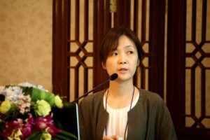 Ms. Hee Jung Choi from Marine Spatial Planning Research Center of KMI, RO Korea shared the status of MSP in RO Korea. Ms. Choi provided a historical overview of MSP in RO Korea which began in 1970s. Some of the highlights include the adoption of Marine Spatial Planning and Management Act in 2008, establishment of integrated MSP in 2017, MSP Planning Roadmap and preparation of MSP Plans for two regional areas in 2018, and the drafting of MSP Strategic Plan (ten-year policy direction) and MSP local plans for four areas in 2019. The zoning scheme of MSP entails basic survey and marine spatial assessment including designation of areas and identification of management measures. The spatial analysis of data and information includes ten key processes/stages, while assessments of different areas entail different assessment parameters depending on the local setting and data availability. In moving forward with ecosystem-based planning, Ms. Choi identified some challenges and recommendations: designation of “environment and ecosystem management zone”; and incorporating marine ecosystem service into MSP (ocean zoning and marine spatial suitability review).
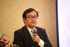
 Dr. Daeseok Kang from Anyang University, RO Korea, presented on emergy value maps as a decision-support tool for MSP in Korea. Dr. Kang indicated that a key component of the marine spatial planning framework under development in Korea is the valuation of marine ecosystem services to provide information that can be used to resolve conflicts among different uses and make decisions on the use and conservation of marine ecosystems and resources. In particular, one of the methodologies for valuation tools that can be used is Emergy along with the preference-based approaches to provide information for better spatial decisionmaking from different perspectives. The emergy methodology is a biophysical approach in the valuation of ecosystem services that provides value maps for marine ecosystem services. In the emergy methodology, the value of a product or service is proportional to the sum of all inputs (energy, materials, information, labor, etc.), expressed in a reference energy (solar energy in the current practice), that were spent to produce it. In a study presented by Dr. Kang, classification of marine ecosystem services, construction of a database for unit emergy values (i.e., conversion factors to calculate emergy quantity from biophysical data), collection of data and information to quantify marine ecosystem services, and construction of emergy value maps that have been carried out for selected marine areas were shown. It was emphasized however that more work is needed, especially to fill the gaps in spatial biophysical data to quantify marine ecosystem services and construct the unit emergy value database that reflects the characteristics of the Korean marine ecosystem.
The session sought further clarification on the benefits of using emergy compared to economic valuations. Dr. Kang indicated that the advantage of emergy method is its ability to have maps, which can be difficult using economic methods which often use the willingness-to- pay approach. He believes that people’s willingness to pay sometimes does not reflect the true value of ecosystem services. He, however, confirmed that emergy method cannot calculate different utilities as some stakeholders may use different ecosystem service as compared to other stakeholders (i.e., fishers vs. tourists).
 Dr. Sakanan Plathong from Prince of Songkla University, Thailand shared the future of Marine Spatial Planning in Thailand focusing on the case of Koh Lan, Pattaya. While Thailand does not share the Yellow Sea, the opportunity provides for knowledge sharing. MSP was implemented at Koh Lan, Koh Khok and Koh Sak, islands located in Pattaya, Chonburi. It is a famous tourist destination for beach recreation, snorkeling, scuba diving and other tourism activities. MSP was prepared for conservation and sustainable uses of these islands. The influx of tourists and various activities have lead to use conflict and natural habitat degradation. In line with this, through the MSP, zonings were identified (marine protection zone, coral reef protection zone, scuba diving zone, etc). Through the MSP efforts, quantitatve methods and in-site survey optimized the layout of marine functional areas, and helped bridge natural science with management.
It was however pointed out that current MSP effort is focusing on sea-based activities/area, but efforts to link land-based have already started. The issue on tourism carrying capacity in the area will also need to be integrated into MSP Plans. It is hoped that lessons and knowledge gained in the area will be further shared to other areas in Thailand in the future.
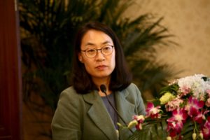
 Dr. Aslan Hwanhi Lee from Seoul National University introduced the coastal wetland ecosystem services in RO Korea. Since the 2000s, several studies have been conducted to ecosystem service valuation of tidal flats and regulating and/or support services factors has been defined in tidal flats. In this study, it was investigated that the value of regulating and/or support services in tidal flats of South Korea, based on: (1) habitat characteristics (i.e., grain size, vegetation); (2) nitrogen stock and denitrification rate; and (3) primary production. The samples were analyzed by elemental analyzer-isotope ratio mass spectrometer (EA-IRMS), (Membrane Inlet Mass Spectrometer) MIMS, oxygen microfiling method, and diving pam II, respectively. Based on the results, the vegetation area showed higher nitrogen stock and/or denitrification rate than bared area. Likewise, muddy tidal flats were showed higher purification efficiency than sandy tidal flats. The primary productivity of tidal flats has been found to be 1.9 times higher than the global average primary productivity values, which is 3.9 times higher than the Wadden Sea region. Overall, the water purification efficiency and primary productivity of tidal flats in Korea are higher than those of salt marshes in other countries and have high value in terms of ecosystem services. It is hoped that the data can be used to determine the future conservative policy direction on tidal flats management.
Session 6 of BD Forum discussed how to build enabling constituency for coastal and marine biodiversity. Dr. Dohoon Kim of Pukyung National University, RO Korea served as moderator, while Mr. Raphael Glemet of IUCN Asia Regional Office served as the rapporteur.
 Ms. Ji Young Jang from Eco-Horizon Institute of RO Korea shared their initiatives related to the MPA education centers in RO Korea. According to Ms. Jang, the network of MPA education centers in ROK was launched in 2011 with the aim of improving conservation, management and effective use of the marine ecosystem on MPA and enhance public awareness and understanding of marine ecosystem conservation. The centers also help facilitate information exchange and joint cooperation activities between the MPA education centers with local communities. A total of 17 institutions are currently in place, while the Ministry of Oceans and Fisheries participates as an advisory body. Ten of them have been established as MPA education centers and are in operation, and three are preparing to build a center. Four institutions are also participating in the network to support them. To further strengthen public education, joint cooperation and strategy are being conducted.
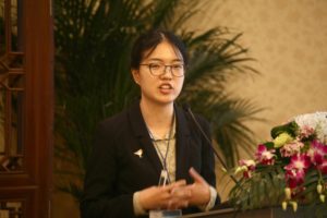 Ms. Ziyou Yang from the Spoon-billed Sandpiper in China introduced their awareness raising and education initiatives for spoon-billed sandpiper in Jiangsu Province. The Southern Jiangsu Province is a critical staging ground for critically endangered spoon-billed sandpiper. This effort not only help safeguard the future of these species but even other specie that make up the ecological community of the Yellow Sea coast. Key activities of SBS China include: fieldwork and monitoring; outreach and education initiatives targeting youth/schools, fishers and business sector. To reach wider public, the SBS China also conducts story telling via popular magazines, and production of capsule toys. In 2018, a total of 65 flag sightings for 33 different individuals were reported by waterbird surveyors and citizen scientists. For next year, SBS-themed classrooms will be established not only for educational purposes but also to help raise funds. Converting shipping containers into bird watching stations and nature centers is also in the pipeline.
Currently, the major funding of SBS China comes from various entrepreneurs in China. Since the initiative was introduced significant progress have been noted particularly in the increase of awareness about spoon- billed sandpiper. Southern Jiangsu Province was also recently declared as a World Natural Heritage site. The session recognized the important roles that NGOs like SBS China play in creating significant changes.
Dr. Dohoon Kim of Pukyung National University, RO Korea, shared information on increasing economic impacts of Yellow Sea Fisheries through marine biodiversity conservation. Studies show that the catch amount of fisheries in the Yellow Sea has been decreasing over time. It has decreased from 264,000 tons in 1986 to 134,000 tons in 2017. According to the results of stock assessment with various models, the potential yield (MSY) of fishery resources in the Yellow Sea was estimated to be about 231 tons. Therefore, through an ecosystem-based management including marine biodiversity conservation, the production can increase in the future. Results of IO analysis showed that both direct and indirect economic impacts of Yellow Sea fisheries would increase by 454 billion Korean won and 744.5 billion Korean won, respectively. In addition, employment could also increase from 18,148 persons to 30,996 persons when the potential yield is achieved.
The session suggested that in the future, it may be good to have data from both RO Korea and China to see status and/or changes on both sides.
 Dr. Dahao Cai from the National Marine Data and Information Service, MNR, PR China, tamarisk in the north introduced the new initiatives in China related to Blue Economy. He cited the following major marine engineering initiatives: blue bay restore project; ecological restoration project of mangrove in the south and China ecological island and reef project. Several major marine programs include: smart ocean program; Jiaolong deep sea exploring program; scientific exploration project of “snow dragon in polar region”; Deep Sea Station project; China Global Ocean Observing System. While key policies related to blue economy include: establishment of marine economic development demonstration area; promote large-scale application of seawater desalination; promote development of marine aquaculture industry reinforce marine ecological protection in coastal areas to increase preventive capacity on marine disasters.
The session discussion cautioned that while the concept of promoting blue economy is good, it is also important to ensure that massive development initiatives will consider the whole structure to effectively achieve the objectives of a blue economy.
To access the Day 1 YSLME Science Conference report, click http://www.yslmep.org/wp-content/uploads/2019/06/DAY-1-YSLME-Science-Conference-Daily-Report.pdf
To access the Day 2 YSLME Science Conference report, click http://www.yslmep.org/wp-content/uploads/2019/06/DAY-2-YSLME-Science-Conference-News-update.pdf
To access other conference details, including presentations and abstracts, click http://www.yslmep.org/?mec-events=3rd-yslme-science-conference.


