 Danube Basin
- River Basin
- Countries
- Black Sea
 ICPDR
ICPDR- About us
- Projects & Programmes
- Publications
- Meetings & Events
- The Convention
Maps of the WFD Roof Report 2004
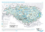
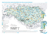
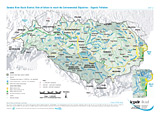
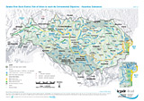
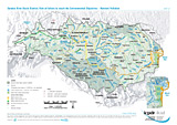
Common layers: Danube River Basin District (DRBD), Danube, Tributaries (river basins > 4,000 km²), Lakes (surface area > 100 km²), Lagoons (surface area > 100 km²), Black Sea Coastal Catchments, Canals, National borders, Cities
Scale: 1 : 4,500,000
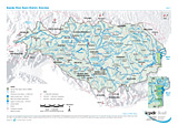
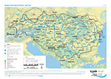
Danube River Basin District Overview
Layer: Competent authority
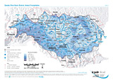
Annual Precipitation
Layer: Total Annual Precipitation
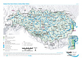
Surface Water Bodies
Layers: River water bodies, Lake water bodies (surface area > 100 km²), Transitional waters bodies, Coastal water bodies, Artificial water bodies
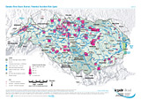
Significant Point Sources of Pollution
Layers: Nuclear power plants, Significant Point Sources (Municipal WWTP, Municipal untreated, Industrial, Agicultural)
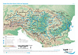
Land Use
Layer: Aggregated land use classes (Coniferous forest, Deciduous forest, Grassland, Wetlands, Arable land, Urbanized area, Sparsly vegetated area, Sea)
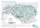
Major Hydraulic Structures
Layers: Hydraulic structures (mainly dams and weirs), Harbours, Waterways ECE I-IV, Waterways ECE V-VII, Free flowing river stretch, Strongly regulated river stretch, Impounded river stretch
Potential Accident Risk Spots
Layers: Potential Accident Risk Spots (WRI 5-6, WRI 6-7, WRI 7-8, WRI 8-9)
Old Contaminated Sites in Potentially Flooded Areas
Layer: Old contaminated sites
Important Heavily Modified Surface Waters (provisional identification)
Layers: Transitional waters, Coastal waters, Heavily modified surface waters (aggregated water bodies according to aggreed criteria for basin-wide importance)
Risk of failure to reach the Environmental Objectives - Organic Pollution
Layers: Surface Water Bodies (Water body at risk, Water body possibly at risk, Water body not at risk)
Risk of failure to reach the Environmental Objectives - Hazardous Substances
Layers: Surface Water Bodies (Water body at risk, Water body possibly at risk, Water body not at risk)
Risk of failure to reach the Environmental Objectives - Nutrient Pollution
Layers: Surface Water Bodies (Water body at risk, Water body possibly at risk, Water body not at risk)
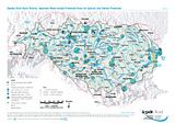
Risk of failure to reach the Environmental Objectives - Hydromorphological Alterations
Layers: Surface Water Bodies (Water body at risk, Water body possibly at risk, Water body not at risk)
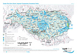
Important Transboundary Groundwater Bodies
Layers: Important transboundary groundwater bodies of different horizons (transboundary areas > 4000 km²)
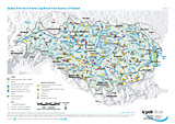
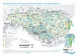
Important Water-related Protected Areas for Species and Habitat Protection
Layers: Areas for species and habitat protection (< 10,000 ha, 10,000 - 50,000 ha, > 50,000 ha), Transboundary co-operation
The information contained in the ICPDR website is intended to enhance public access to information about the ICPDR and the Danube River. The information is correct to the best of the knowledge of the ICPDR Secretariat. If errors are brought to our attention we will try to correct them.
The ICPDR, expert group members, nor other parties involved in preparation of information contained on this website cannot, however, be held responsible for the correctness and validity of the data and information provided, nor accept responsibility or liability for damages or losses arising directly or indirectly from the use of the information conveyed therein.
Only those documents clearly marked ICPDR documents reflect the position of the ICPDR.
Any links to other websites are provided for your convenience only. The ICPDR does not accept any responsibility for the accuracy, availability, or appropriateness to the user's purposes, of any information or services on any other website.
When using the information and material provided on this website, credit should be given to the ICPDR.