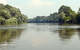
Tisar 2007
Development of Tisza River Basin Management Plan
Summary of the Project
Objectives
One of the key elements of the EU WFD is to ensure that all water meets `good status` by 2015. The first step towards the objective is to create a River Basin Management Plan by 2009. The countries may supplement the River Basin Management Plan with more detailed programmes and management planes for sub-basin. On this basis, the Tisza countries signed a Memorandum of Understanding in December 2004 to work together in the frame of the ICPDR aiming at to produce a sub-basin level Tisza River Basin Management Plan by 2009. This Plan will also integrate issues on flood management. The first step was the preparation of the Tisza Analysis Report in 2007, which includes an overall characterisation of the basin, an analysis of anthropogenic pressures and impacts. The objectiveis to contribute to the preparation of the basis of the further Tisza River Basin Management Plan, which planned to be completed in the frame of a multi-national project "Intergrating multiple benefits of wetlands and floodplains into improved transboundary management of the Tisza River Basin" mainly co-financed by UNDP-GEF. The ICPDR is to ensure consistency of the project with its own work and integration of the results in the preparation of a wider Danube River Basin Management Plan.
Actions
- Development of the Tisza Analysis Report and contribution to the preparation of the Tisza River Basin Management Plan
- Preparation of GIS for the Tisza River Sub Basin
- Development of Flood Management Strategy and Action Plans
 Development of the Tisza Analysis Report and contribution to the preparation of the Tisza River Basin Management Plan: three parts of the analysis report was prepared (1) Characterization, (2) Water Quality report and the (3) Cross cutting issues. The report was coordinated by the country representatives together with the experts. A special workshop was organised to discuss the key water management issues for the Tisza River Basin.
Preparation of GIS for the Tisza River Sub Basin: the two actions, ' Preparation of GIS database for the Tisza River Sub Basin' and ' development of Maps for the Tisza Analysis report' was carried out. The Tisza database is an integrated part of the Danube database as well as to the national database.
 Development of Flood Management Strategy and Action Plans: Emphasise is on the preparation of the study on Water Quantity and Flood Management issues in the Tisza River Basin. The study will discuss issues on water resources and water demand as well as key water quantity management issues. The Flood Management Strategy is planned to be a part of the Tisza Analysis Report as well as a step toward the future River Basin Management Plan.
Financial contribution by the EU for 2007-2008: 150 000 EUR
Celebrating the Tisza River in frame of the Danube Day 2007
29 June 2007: In the frame of Danube Day (Celebrating Danube Cultures), Slovakia, Hungary and Ukraine called the attention/introduce the assets of the Tisza River Sub-basin by preparing leaflets, media materials
 Tisza River Basin a European Model for Ministerial Action (Belgrade Ministerial Conference)
11 October 2007: In the frame of the `Environment for Europe` - Sixth Ministerial Conference` the results of the Preliminary Analysis of the Tisza River Basin – 2007 were introduced in the frame of a side event – press conference.
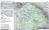
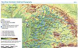
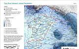
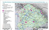
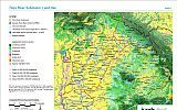
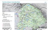
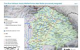
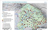
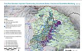
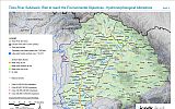
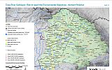
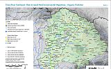
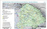
Maps
Maps about the Tisza River Basin have been developed based on the ICPDR DanubeGIS. The maps were harmonized with the report 'Preliminary Analysis of the Tisza River Basin – 2007' and aim to illustrate the main characteristics of the basin.
The following maps of the Tisza River Basin can be found below:
- Tisza River Basin - Overview
- Topography and relief
- Protected areas
- Land uses
- Surface water bodies identified
- Heavily Modified Water Bodies
- Surfacewater Monitoring
- Groundwater Monitoring
- Risk assessment related to hydromorphological alteration
- Risk assessment related to nutrient pollution,
- Risk assessment related to organic pollution
- Risk assessment related to hazardous substances
- Groundwater bodies
Summary Report - A call for action
Initial step toward the Tisza River Basin Management Plan – 2009
Memorandum of Understanding, Bilateral river committees, International agreements, The competent authorities for WFD implementation, Public Participation (projects and list of NGOs), Construction of the Danube-Tisza-Danube Canal System, Reservoirs, List of surface waters bodies evaluated in Part...
Tisza River Sub-basin, February 2008
Tisza River Sub-basin, February 2008
Tisza River Sub-basin, February 2008
Tisza River Sub-basin, February 2008
Tisza River Sub-basin, February 2008
Tisza River Sub-basin, February 2008
Tisza River Sub-basin, February 2008
Tisza River Sub-basin, February 2008
Surface Layers Permeability, Isohyets of the Multi-Annual Mean Precipitation, Mean Annual Runoff, Flood Defences (Hungary, Ukraine), Improvement of Flood Conveyance Capacity (Hungary), Flood (Hungary), Historic Flood, Flooded Areas during 1998-2006, Distribution of the Aridity Factor, Deviation...
Disclaimer
The information contained in the ICPDR website is intended to enhance public access to information about the ICPDR and the Danube River. The information is correct to the best of the knowledge of the ICPDR Secretariat. If errors are brought to our attention we will try to correct them.
The ICPDR, expert group members, nor other parties involved in preparation of information contained on this website cannot, however, be held responsible for the correctness and validity of the data and information provided, nor accept responsibility or liability for damages or losses arising directly or indirectly from the use of the information conveyed therein.
Only those documents clearly marked ICPDR documents reflect the position of the ICPDR.
Any links to other websites are provided for your convenience only. The ICPDR does not accept any responsibility for the accuracy, availability, or appropriateness to the user's purposes, of any information or services on any other website.
When using the information and material provided on this website, credit should be given to the ICPDR.