Tisza Basin
- the largest sub-basin of the Danube

The Tisza is the longest tributary of the Danube (966 km) and drains an area of 157,186 km² in five countries (Slovakia, Ukraine, Hungary, Romania, Serbia).
The Tisza can be divided into three main sections:
- the mountainous Upper Tisza in Ukraine, upstream of the Ukrainian-Hungarian border
- the Middle Tisza in Hungary, which is joined by large tributaries including the Bodrog and the Slaná/Sajó ( both fed by water from the Carpathian Mountains in Slovakia and Ukraine), as well as the Somes/Szamos, the Crisul/Körös River System and the Mures/Maros from Transylvania
- the Lower Tisza downstream of the Hungarian-Serbian border, fed directly by the Bega/Begej, and indirectly by other tributaries via the Danube – Tisza – Danube Canal System
The Tisza River got into the global spotlight in the early 2000, when two industrial accidents occurred on its tributaries in north-western Romania.
On the evening of 30 January 2000, a tailings pond burst at a facility near the city of Baia Mare (Romania), which served for reprocessing old mining tailings and re-depositing the waste sludge. This led to approximately 100,000 m³ of waste water containing up to 120 tonnes of cyanide and heavy metals being released into the Lapus River, then travelling downstream into the Somes and Tisa rivers into Hungary before entering the Danube.
On 10 March 2000, another tailings dam burst in Baia Borsa in the same region close to the Ukrainian border. While some of this material was retained within the dam complex, 20,000 tonnes of sediments were released into the Novat River, a tributary of the Viseu and Tisza rivers.
Did you know?
Every year for some days between late spring and early summer the Tisza is blooming with millions of `Tiszaflowers`. This long-tailed mayfly (Palingenia longicauda) is the largest in Europe and called `Tiszaflower` by the Hungarians. It lives for 3 years as larvae at the river bottom and breaks at the surface where males molt and females hatch. Juts before sunset the beautiful bridal-dance called `blooming` begins and the river’s surface explodes to life. Shortly after the mating, females lay eggs on the river from where they drift to the bottom. The spectacle is over and darkness covers millions of dead bodies on the river surface ... the mayflies perish.
Analysis of the Tisza River Basin
Under the EU Water Framework Directive (2000/60/EC) the ICPDR is the platform for coordination amongst the Danube countries including EU Member States, accession countries and other Danube riparian states for the implementation of the provisions of the Directive at transboundary level. In addition to the Danube River Basin planning, the ICPDR is taking an active role in sub-basin planning as well. One of the key objectives of the EU Water Framework Directive (WFD) is to ensure that all water meets `good status` by 2015. A key step towards this objective is the development of a River Basin Management Plan by 2009.
At the first ministerial meeting of the ICPDR countries in December 2004, ministers and high-level representatives of the five Tisza countries signed the Memorandum of Understanding (Towards a River Basin Management Plan for the Tisza River supporting sustainable development of the region). The ICPDR established the Tisza Group for coordination as well as implementation. The Tisza Group is the platform for strengthening coordination and information exchange related to international, regional and national activities in the Tisza River Basin and to ensure harmonisation and effectiveness of related efforts. The Tisza Group countries agreed on to prepare a sub-basin plan (the Tisza River Basin Management Plan) by 2009, which integrates issues on water quality and water quantity, land and water management, flood and drought.
The first step towards the objective was the preparation of the Tisza analysis report by 2007 (Analyis of the Tisza River Basin – 2007), which was the first milestone in implementing the Memorandum of Understanding. It characterises the Tisza River and its basin, identifies the key environmental and water management problems, in relation to water quality and water quantity, and creates the basis for further steps. Following the identification of the key water management issues, the next milestone is to prepare an integrated Tisza River Basin Management Plan by 2009.
This Analysis was an intermediate step between the WFD Article 5. report submitted in March 2005 (prepared at both the Danube River Basin level, ‘Roof Report’ and national reports) and the River Basin Management Plan to be submitted in 2009. This report is presented in four main sections:
- Part 1 presents the overall characteristics of the basin including, geography, climate, hydrology, land use, basic socio-economic information, etc.
- Part 2 presents the detailed characterisation of the water quality of the basin and expands the information collected for the WFD Article 5. report submitted in 2005 – Danube Roof Report
- Part 3 presents the detailed characterisation of the water quantity of the basin. This represents significant new information of the impacts of floods and droughts, use of water, etc.
- Part 4 integrates the issues in the basin, specifically on how water quantity impacts water quality.
The Tisza River Basin Analysis Report gives an overview of the following waters:
- the Tisza River and its tributaries with a catchment size of >1 000 km²;
- natural lakes >10 km²
- reservoirs
- main canals
- groundwater bodies >1,000km²
The Tisza Group under the ICPDR was responsible for this Analysis Report.
The International Baia Mare Task Force (BMTF)
An International Task Force (ITF) involving the ICPDR was set up on 25 February 2000 at the initiative of the European Commission in response to the pollution incident.
The ITF's main assignments were: to assess damage, to investigate what caused the accident, to outline measures to be taken to prevent such a disaster from happening again.
The task force assessed the causes of the accident, and made a set of recommendations related to the strengthening of the regulatory framework and improved operational practices.
As part of its mandate, the ITF was given the task of publishing an Inventory of High Risk Sites in the mining, extractive and ore-processing industries in the Tisza river basin. These sites included dams and 'tailings ponds' storing mining wastes and sludge containing heavy metals and other toxic substances used in the mining and processing of metal ores. If these sites are poorly designed or maintained, they can pose a serious threat of significant pollution into river systems, either due to chronic leakage or catastrophic dam failure during periods of bad weather. While some of these plants are still in operation, many sites have been abandoned and are in a poor state of repair from a lack of maintenance.
The Ministers of Environment of Romania, Hungary, Slovakia and Ukraine agreed in April 2000 to undertake the task of preparing such an inventory under the auspices of the ICPDR. The resulting list covers a wider range of 'hotspots' than solely those in the mining and extractive industries. Nevertheless, for those sites identified within the mining, extractive and ore-processing industries, the ITF sought assurances from the responsible Government that, immediate actions would be taken by the competent authorities of each country.
Ministerial Statement towards the development and implementation of a River Basin Management Plan for the Tisza River Basin
On the 16th February in Vienna ministers and high-level representatives responsible for water management from the Danube River Basin countries joined and discussed about the achievements and future needs/actions related to the Danube River Basin. In the frame of the high level ministerial meeting - hosted by the International Commission for the Protection of the Danube River (ICPDR) - ministers and high-level representatives from Hungary, Romania, Serbia, Slovakia, Ukraine adopted the `Ministerial Statement towards the development and implementation of a River Basin Management Plan for the Tisza River Basin’.
Towards a River Basin Management Plan for the Tisza river supporting sustainable development of the region Document signed by the Ministers of the Tisza countries.
Summary Report - A call for action
Initial step toward the Tisza River Basin Management Plan – 2009
Memorandum of Understanding, Bilateral river committees, International agreements, The competent authorities for WFD implementation, Public Participation (projects and list of NGOs), Construction of the Danube-Tisza-Danube Canal System, Reservoirs, List of surface waters bodies evaluated in Part...
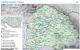
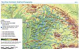
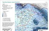
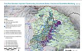
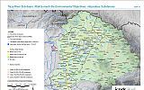
Tisza River Sub-basin, February 2008


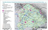
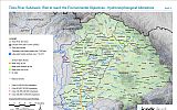
Tisza River Sub-basin, February 2008
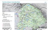
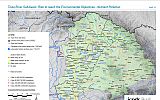
Tisza River Sub-basin, February 2008
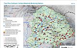
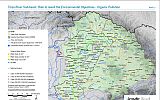
Tisza River Sub-basin, February 2008
Tisza River Sub-basin, February 2008
Tisza River Sub-basin, February 2008
Tisza River Sub-basin, February 2008
Tisza River Sub-basin, February 2008
Surface Layers Permeability, Isohyets of the Multi-Annual Mean Precipitation, Mean Annual Runoff, Flood Defences (Hungary, Ukraine), Improvement of Flood Conveyance Capacity (Hungary), Flood (Hungary), Historic Flood, Flooded Areas during 1998-2006, Distribution of the Aridity Factor, Deviation...
Disclaimer
The information contained in the ICPDR website is intended to enhance public access to information about the ICPDR and the Danube River. The information is correct to the best of the knowledge of the ICPDR Secretariat. If errors are brought to our attention we will try to correct them.
The ICPDR, expert group members, nor other parties involved in preparation of information contained on this website cannot, however, be held responsible for the correctness and validity of the data and information provided, nor accept responsibility or liability for damages or losses arising directly or indirectly from the use of the information conveyed therein.
Only those documents clearly marked ICPDR documents reflect the position of the ICPDR.
Any links to other websites are provided for your convenience only. The ICPDR does not accept any responsibility for the accuracy, availability, or appropriateness to the user's purposes, of any information or services on any other website.
When using the information and material provided on this website, credit should be given to the ICPDR.