Total and regional Runoff to the Baltic Sea
Key message
During the last 11 years the total inflow to the Baltic Sea has decreased from a top flow rate of over 17 500 m3/s in 1998 to less than 11 000 in 2003. The two following years the runoff slightly increased to just below the mean value for the years 1950 to 2006. In 2006 the runoff was very low, just reaching about 11 000 m3/s. In 2008, the flow of 14 473 m3/s is much higher and above the mean.
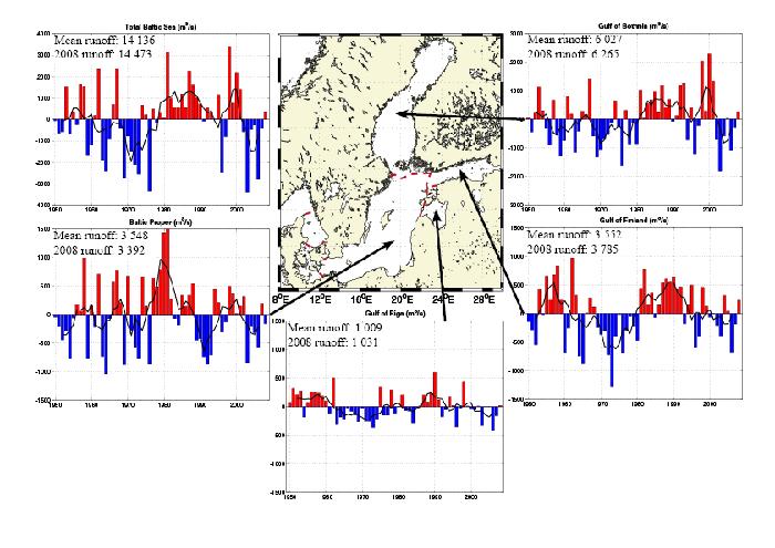
All sub basins but the Baltic Proper, had higher runoff values in the year 2008 compared to the mean values. The difference to the mean value was about 4% in the Gulf of Bothnia, 6% in the Gulf of Finland, 2% in the Gulf of Riga and -4% in the Baltic Proper (the negative sign indicate lower runoff compared to the mean value). When looking at the entire Baltic Sea, the difference to the mean value was about 2% hence the general runoff for the entire area was slightly higher compared to the yearly mean runoff value.
During the period 1950 – 2008, the total runoff to the Baltic Sea area shows no long-term trend. On the other hand this time period is characterised by dry and wet periods lasting for a couple of years to a decade generally following the NAO index.
Figure 1:
Total runoff deviation during the years 1950 - 2008 to the Baltic sub basins based on annual mean values. The mean runoff value and the 2008 value for each sub basin are written within each figure. The black line is the running mean over 5 years.
Results and Assessment
Relevance of the indicator for describing developments in the environment
Runoff is a quantitative background indicator on the freshwater discharge, carrying the nutrients from the drainage areas to the coast.
Runoff is an important parameter on the change of pressure on nutrient supply due to varying climate and climate change. Also change in land-use can influence runoff. To evaluate the change of pressure on nutrient supply to the Baltic region it is necessary to know the variability of runoff and normalise for this natural variability. Dry periods, like the one during the 70’s, can mask the marine eutrophication since the runoff was lower than average and hence also the total load of nutrients. Extended dry periods should also lead to a slight increase in surface layer salinity. During wet periods, the total nutrient load (pressure) increase, making marine eutrophication (effects) even worse.
The indicator shows the annual runoff from drainage areas but integrated over the Baltic sub-regions. Runoff is governed by the precipitation - evaporation on land areas and is also influenced by air temperature. It is the sum of direct river and diffusive runoff. In all sub-regions a strong seasonal, annual and decadal variability can be distinguished. Especially wet and dry periods are characterising the runoff. The 70’s was a fairly dry period compared with the 80’s and the later part of the 90’s. Geographically, the runoff is of about the same size in the Gulf of Finland and the Baltic Proper, whereas the Gulf of Riga contributes to a lesser extent and the Gulf of Bothnia to a larger extent to the total runoff.
Assessment
Four different sub basins are described as deviation from their mean value based on runoff during 1950 to 2007. The mean value and the 2008 value are written in the top left corner in each sub basin figure (figure 1). Years with higher runoff compared to the mean value are displayed as red bars in the positive direction and lower values with blue bars in the negative direction. A running mean over five years is displayed as a black line overlaying the bars in the figure. The sub basins are displayed in the centre of figure 1 and the sub basins described are the Baltic Proper, the Gulf of Riga, the Gulf of Finland and the Gulf of Bothnia. A figure with the sum of the Baltic Sea sub basins is also included, partly to give an overview of the entire Baltic Sea and partly to compare the annual changes to the NAO index.
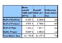
During the period 1950 – 2008, there is no obvious trend in the annual runoff, neither in the total runoff to the Baltic Sea area, nor in the sub-regions. On the other hand this time period is characterised by dry and wet periods lasting for a couple of years to a decade. 2008 was a year with runoff close to the normal values, see table 1. The difference from the mean runoff is of similar size to the year 2007, but with opposite sign. All sub basins but the Baltic Proper had higher runoff values in the year 2008 compared to the mean values from 1950 to 2007.
The difference to the mean value was about 4% in the Gulf of Bothnia, 6% in the Gulf of Finland, 2% in the Gulf of Riga and -4% in the Baltic Proper (the negative sign indicate lower runoff compared to the mean value). When looking at the entire Baltic Sea, the difference to the mean value was about 2% hence the general runoff for the entire area was slightly higher compared to the yearly mean runoff value.
Table 1:
Mean of the annual mean runoff values [m3/s] for the sub basins in the Baltic Sea compared to the 2008 values and the difference in %.
At times, there have been similar features in the changes of the runoff values for all the sub basins. Other time periods, the changes are similar only in some of the sub basins. All the sub basins had low runoff values in the early to the mid 70’s and higher in the end of the 90’s. In the Baltic Proper, the Gulf of Riga and the Gulf of Finland, there were high values from the mid 50’s to the start of the 60’s. In the Gulf of Bothnia, the Gulf of Riga and the Gulf of Finland, there was a feature of increasing values during the 80’s while in the Baltic Proper, there was a feature of decreasing values. There were low values in the Baltic Proper in the early 90’s while there were high values in the end of the 80’s and the start of the 90’s in the Gulf of Riga, the Gulf of Finland and the Gulf of Bothnia.
The total runoff to the Baltic Sea is mostly influenced by the sub basins with the largest contributions, obviously. The highest contribution is from the Gulf of Bothnia followed by the Gulf of Finland and the Baltic Proper. By comparing the Gulf of Bothnia to the Gulf of Finland, there is a rather good correlation in the features of the running mean values. By comparing the Gulf of Bothnia to the Baltic Proper, there are some correlations but also some deviations in the features. By making a generalization, the figure displaying the total runoff to the Baltic Sea, represents the general features of the different sub basins rather well. By making this generalisation, only the figure displaying the total runoff to the Baltic Sea is compared to the NAO index.
Figure 2:
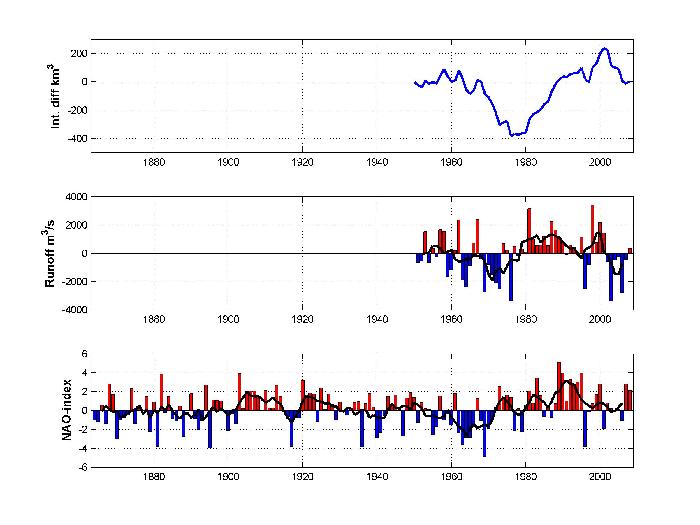
Total runoff deviation during 1950 - 2008 to the Baltic Sea and the NAO index during the years 1864 - 2008 based on winter mean values of the NAO index. Positive index indicates stronger westerly winds bringing warmer and wetter winters to Scandinavia. The black line is the running mean over 5 years.
Figure 2 displays the total runoff deviation during 1950 to 2008 to the Baltic Sea, both as integrated difference (sum of abnormalities, starting and ending with 0 km3 1950 and 2008) and with bars displaying the year to year deviation from the mean. The NAO index during the years 1864 - 2008 based on winter mean values of the NAO index is displayed in the bottom of the figure. The integrated difference gives an idea of the total amount of runoff in the Baltic Sea. The black line is the running mean over 5 years. By comparing the running mean of the two lower figures between 1952 and 2006, the features correspond rather well with each other. Since the correlation is good, the NAO indices may be used to indicate general runoff to the Baltic Sea back in time. This is the motivation of including the longer time series of the NAO indices as well as looking for possible oscillation features extending the 58 year time scale. There is a slight tendency to high NAO indices around 1910 and 1990 and low values around 1880 and 1960. This forms an oscillation over 80 years. By looking at this 1.5 oscillation, it is not possible to draw conclusions, but comments can be made. To go from generally high values to generally low values takes approximately 50 years while going from generally low values to generally high values takes approximately 30 years. The recent peak of the NAO index occurred in 1990. If the comment concerning the 80 year oscillation is true, we are 18 years downhill the NAO index slope and we will continue that ride for approximately 32 years, with weaker westerly winds resulting in colder and dryer winters in Scandinavia.
References
Bergström, S. And B. Carlsson 1994. River runoff to the Baltic Sea 1950 - 1990. AMBIO Vol. 23, No. 4-5, 280 - 287.
Graham, Phil 1999. Modelling runoff to the Baltic Sea. AMBIO Vol. 28, No. 4, 328-334.
http://www.cgd.ucar.edu/cas/jhurrell/Data/
Data
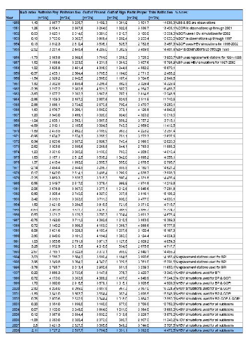
Observations are collected at the BALTEX Hydrological Data Centre (http://www.smhi.se/sgn0102/bhdc/bhdc.htm), whereas modelled data is done at SMHI using the HBV-model (Graham-99). Gulf of Riga runoff is based observations up through 2001, while simulations are used for 2002. Gulf of Finland runoff is based on observations up through 1997, while simulations are used for 1998-2002. Baltic Proper runoff is based on observations up through 1996, while simulations are used for 1997-2003. For 2003 to 2008 all data is based on model simulations carried out by Dr. Phil Graham, SMHI. The NAO indices are collected from http://www.cgd.ucar.edu/cas/jhurrell/Data/.
Table 2:
NAO index and annual mean values of runoff [m3/s] to the sub basins in the Baltic Sea during 1950 to 2008.
